Forest complex terrain correction and forest height inversion methods and systems with backscattering optimization

A backscattering and complex terrain technology, applied in the field of image processing, can solve problems such as difficult to meet the needs of quantitative remote sensing inversion, limited precision, and less research on undulating environments

Inactive Publication Date: 2015-10-28
WUHAN UNIV
View PDF2 Cites 28 Cited by
  • Summary
  • Abstract
  • Description
  • Claims
  • Application Information

AI Technical Summary

Problems solved by technology

Because the influence of elevation can be considered in the collinear equation, this method is more accurate than the polynomial correction method when the influence of terrain fluctuations is relatively large, but the DEM within the influence range must be generated first, otherwise in the absence of digital ground elevation In the case of the image correction will become complicated and difficult
3) The correction method based on the imaging principle of SAR itself. This method was originally proposed by F. Leberal for the airborne SAR with the slope range equation and the zero-Doppler equation, but it has some shortcomings when dealing with spaceborne SAR images. For example, the Doppler of spaceborne SAR is generally not zero, and the distance changes greatly, so it is necessary to establish an imaging model suitable for spaceborne SAR
[0007] However, with the development of remote sensing technology, the current method based on geometric interpolation is difficult to meet the inversion requirements of quantitative remote sensing due to its limited accuracy. In radiation correction, the terrain factor is often relatively flat or only considers the influence of terrain tilt, while for There are few researches on the fragmented landscape and undulating and changing environment. At the same time, due to the existing changing terrain, it has not been possible to conduct accurate simulation analysis of real forest scenes in combination with simulation data.
In addition, in the actual tree height parameter estimation, due to certain differences in the distribution and structure of different tree species, there are differences in the variation of the incident angle, which not only directly affects the accuracy of radiation correction, but also adopts a unified model for tree height estimation. There will be some errors in the inversion
There is no related technology that can solve the problem in this field

Method used


Image

  • Forest complex terrain correction and forest height inversion methods and systems with backscattering optimization
  • Forest complex terrain correction and forest height inversion methods and systems with backscattering optimization
  • Forest complex terrain correction and forest height inversion methods and systems with backscattering optimization

Examples


Embodiment Construction

[0073] The technical solution of the present invention will be described in detail below in conjunction with the drawings and embodiments.

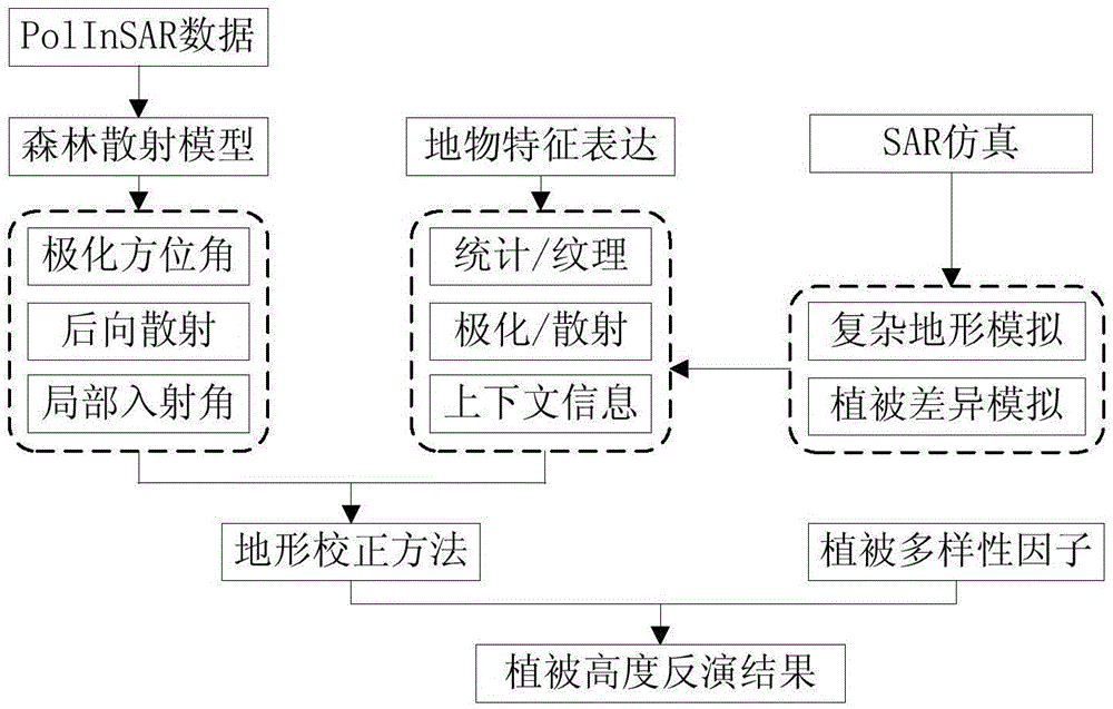
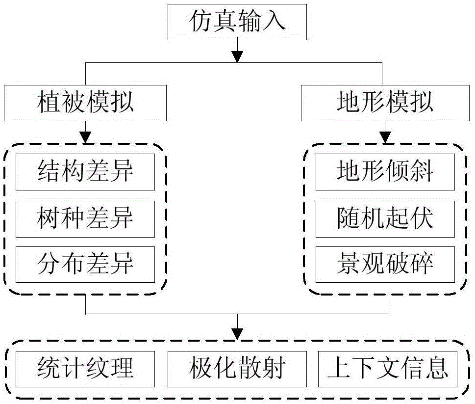
[0074] The invention considers combining simulation data to conduct qualitative analysis on the polarization scattering characteristics of the forest, and realizes terrain correction by integrating geometry and radiation methods. Such as figure 1 , for the terrain effect analysis of the complex forest scene, the present invention first analyzes the construction method of the forest scattering model of PolInSAR data, especially for the variables related to the terrain such as polarization azimuth, backscattering coefficient, and local incident angle. Then, the description methods of statistical texture features, polarization scattering features, and context features of these parameters are analyzed, and combined with simulation data analysis, a corresponding parameter correction algorithm is formed, combined with geometric correction and r...


PUM


Abstract

The invention provides forest complex terrain correction and forest height inversion methods and systems with backscattering optimization. The terrain correction comprises: constructing a two-layer-structure coherent model aiming to polarized interference SAR images of a forest scene and according to the characteristics of two-layer scattering of the forest scene, and correcting parameter changes caused by the terrain; establishing a quantitative description relation between vegetation and the terrain with the combination of terrain simulation and vegetation simulation; and finally performing correction with the combination of the range-Doppler geometric correction mode and normalized radiation correction mode. The forest height inversion comprises bringing forward tree species diversity factors aiming to structures of different tree species and distribution difference, the vegetation heights of different tree species are respectively estimated, and the forest height inversion result of the whole forest scene is obtained. By adopting the methods and the systems, terrain effect analysis and compensation of forest complex scenes can be effectively realized; besides, the inversion precision of vegetation height is improved with the combination of the tree species diversity factors.

Description

technical field [0001] The invention belongs to the technical field of image processing, and in particular relates to a technical scheme for optimizing backscattering for polarization interference SAR forest complex land surface effect analysis and tree height inversion. Background technique [0002] Forests play an important role in global hydrology, ecology, carbon cycle, and climate change. Parameters such as forest type, stand structure, height, and biomass are the main parameters in forest resource information investigation. With the development of remote sensing technology, polarimetric interferometric SAR technology, which has the advantages of polarization and interferometric technology, has gradually become an irreplaceable technology in forest resources investigation with its unique advantages of all-weather and low cost. is playing an increasingly important role in the quantitative inversion of forest parameters. Research on forest classification, forest height r...

Claims


Application Information

Patent Timeline
Patent Type & Authority Applications(China)
IPC IPC(8): G01S13/90
CPCG01S13/9023G01S13/9027G01S13/9076
Inventor 何楚陈语韩功张宇
Owner WUHAN UNIV
Why Eureka
Try Eureka