Multiple-UAV operation information display system

An information display, multi-UAV technology, applied in three-dimensional position/channel control and other directions, can solve the problems of not indicating the relative relationship between UAVs, battlefield situational awareness, data interference, etc., to improve mobility and flexibility, enhance The effect of situational awareness, enhanced control

Active Publication Date: 2015-11-11
XIDIAN UNIV
View PDF4 Cites 36 Cited by
  • Summary
  • Abstract
  • Description
  • Claims
  • Application Information

AI Technical Summary

Problems solved by technology

Under normal circumstances, vehicles are limited by factors such as size and weight, and cannot be equipped with multiple sets of UAV systems, and the existence of multiple sets of systems may also cause problems such as data interference.
Therefore, with the current technical means, the realization of multi-UAV swarm combat missions still depends on multiple separate single-UAV ground control stations for control. Obviously, this method cannot provide operators with comprehensive information on the entire UAV group and the battlefield situation. It is also difficult to complete multi-UAV coordination and control tasks
[0004] In addition, for some unmanned helicopter ultra-low-altitude cluster combat missions, unmanned helicopters will face complex environments when flying at low altitudes, and are prone to contact with ground obstacles, which will cause flight accidents and affect cluster control and combat efficiency. However, the existing UAV control information does not indicate the relative relationship between the UAV and the terrain, and cannot effectively support multi-UAV ultra-low-altitude flight missions.

Method used


Image

  • Multiple-UAV operation information display system
  • Multiple-UAV operation information display system
  • Multiple-UAV operation information display system

Examples


Embodiment Construction

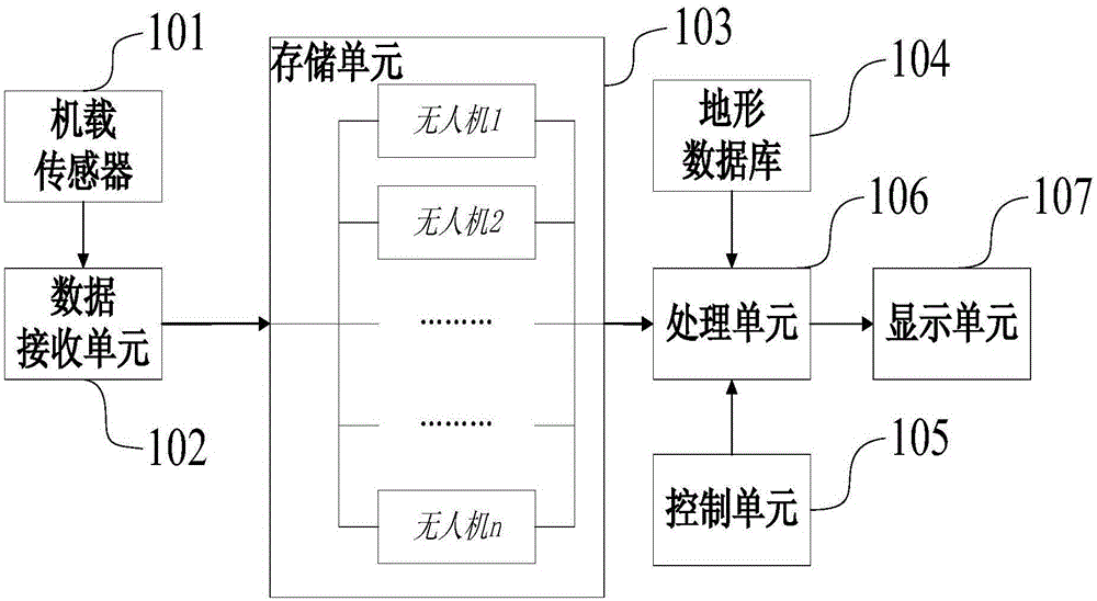
[0028] figure 1 A structural block diagram of a multi-UAV control information display system is given, including a data receiving unit 102 that accepts flight status data and image data from the onboard sensor 101, and the data receiving unit 102 classifies and stores the received data in In the storage unit 103, the specific process is to classify and store the data of each individual drone. Then a processing unit 106 calculates and generates a comprehensive information display set according to the flight state information of each drone in the storage unit 103, the virtual terrain information in the terrain database 104, and the control options of the control unit 105, and finally the display unit 107 completes the display set. Displays the aggregate information display set.

[0029] The airborne sensor 101 can detect the flight status information of the UAV, including speed, altitude, heading, wind speed and direction, time, geographic location and mechanical parameters, wh...


PUM


Abstract

The present invention discloses a multiple-UAV operation information display system which comprises a data receiving unit for receiving flying state data and image data from airborne sensors and classifies and stores into a storage unit corresponding to each UAV, then a processing unit calculates and generates an integrated information display set according to the flying state information, terrain database information of each UAV in the storage unit and the control options of a control unit, and a display unit combines a display parameter and displays the integrated information display set in the whole. According to the system, the relative positions of multiple UAV can be displayed in an integrated way, the relative relationship of UAVs flying at a low altitude and terrain and obstacles on the ground is displayed in a highlighted way, the state sensing ability of control personnel is effectively enhanced, and the system is especially for a multiple-unmanned-helicopter cluster application.

Description

technical field [0001] The invention belongs to the field of UAV control information display, and in particular relates to a multi-UAV control information display system. Background technique [0002] UAV cluster combat has become an inevitable trend in the development and application of UAVs in the future. At present, the control of UAVs mainly relies on the UAV ground control station, which supports the operator to control the UAV by displaying the flight status information of the UAV. [0003] Traditional UAV ground control stations generally can only control a single UAV and display its flight status information and mission information. At the same time, in order to ensure mobility and flexibility, UAV ground control stations often exist in the form of vehicles. Under normal circumstances, vehicles are limited by factors such as size and weight, and cannot be equipped with multiple sets of UAV systems, and the existence of multiple sets of systems may also cause problem...

Claims


Application Information

Patent Timeline
Patent Type & Authority Applications(China)
IPC IPC(8): G05D1/10
Inventor 刘贵喜张佳明周杰张家立李斯史琳婕
Owner XIDIAN UNIV
Why Eureka
Try Eureka