Inertial navigation platform and Beidou satellite-based high-precision and ultra-tightly coupled navigation method

A Beidou satellite and ultra-tight coupling technology, applied in the field of high-precision navigation, can solve problems such as high system complexity

Inactive Publication Date: 2015-12-02
PLA PEOPLES LIBERATION ARMY OF CHINA STRATEGIC SUPPORT FORCE AEROSPACE ENG UNIV
View PDF3 Cites 23 Cited by
  • Summary
  • Abstract
  • Description
  • Claims
  • Application Information

AI Technical Summary

Problems solved by technology

[0005] Ultra-tight coupling is a new concept navigation method for integrated navigation, which has high practical significance and performance parameters, but at the same time, its system complexity is also the highest

Method used


Image

  • Inertial navigation platform and Beidou satellite-based high-precision and ultra-tightly coupled navigation method
  • Inertial navigation platform and Beidou satellite-based high-precision and ultra-tightly coupled navigation method
  • Inertial navigation platform and Beidou satellite-based high-precision and ultra-tightly coupled navigation method

Examples


Embodiment Construction

[0125] specific implementation plan

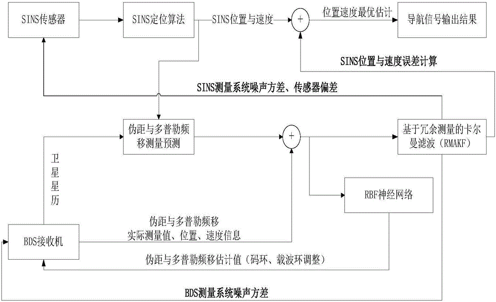
[0126] Specific embodiments of the present invention are as figure 1 As shown, the specific implementation steps are as follows:

[0127] (1) Establish a random linear steady discrete system model according to the state equation and measurement equation of the moving object:

[0128] X k = Φ k , k - 1 X k - 1 + Γ k , k - 1 W ...


PUM


Abstract

The invention relates to an inertial navigation platform and Beidou satellite-based high-precision and ultra-tightly coupled navigation method. According to the method, a stochastic linear time-invariant discrete system mechanical model is established according to a moving object state equation and a measurement equation; statistic analysis is performed on the first-order difference sequence and second-order difference sequence of redundancy measurement values of a system, so that a redundancy measurement-based adaptive Kalman filtering algorithm can be realized, and therefore, the measurement noises of the system can be estimated accurately, and noise variance R can be adjusted adaptively; according to a traditional ultra-tightly coupled structure, a neural network prediction module is introduced so as to be used for assisting a Beidou satellite carrier tracking loop and a code tracking loop under a lock loss state; a time delay filter is adopted for a Beidou satellite receiver, and therefore, the correlation between loop tracking errors and update time in the ultra-tightly coupled system can be significantly improved. The method of the invention belongs to the navigation control technical field and can be applied to high-precision navigation of carriers carrying strapdown inertial navigation platforms.

Description

technical field [0001] The invention relates to a high-precision ultra-tight coupling navigation method of an inertial navigation platform and a Beidou satellite, which is suitable for high-precision navigation of various carriers equipped with a strapdown inertial navigation platform. technical background [0002] The two basic navigation methods in today's navigation field are inertial navigation system (INS) and satellite-based positioning system represented by GPS and BDS. At the same time, these two navigation systems have strong complementarities, and have always been a hot spot in the research of integrated navigation in recent years; inertial navigation has the advantages of strong autonomy, no environmental influence, and high navigation accuracy in a short period of time; satellite navigation has the advantages of positioning High precision and good time stability. The working characteristics of the two just complement each other in terms of performance. Satellite...

Claims


Application Information

Patent Timeline
Patent Type & Authority Applications(China)
IPC IPC(8): G01S19/47
CPCG01S19/47
Inventor 任元苏靖轩邵琼玲陈晓岑缪存孝蔡远文李新洪汪洲
Owner PLA PEOPLES LIBERATION ARMY OF CHINA STRATEGIC SUPPORT FORCE AEROSPACE ENG UNIV
Why Eureka
Try Eureka