Vehicle-mounted GPS space-time trajectory big data optimization method and system

A space-time trajectory and big data technology, applied in the direction of electrical digital data processing, special data processing applications, radio wave measurement systems, etc., can solve the problems of inability to achieve GPS trajectory data quality, optimization, etc., to improve the overall positioning accuracy, easy to implement , the effect of simple optimization method

Active Publication Date: 2015-12-09
WUHAN UNIV
View PDF8 Cites 44 Cited by
  • Summary
  • Abstract
  • Description
  • Claims
  • Application Information

AI Technical Summary

Problems solved by technology

Although these methods provide data sources that meet the corresponding accuracy requirements for subjects with different research purposes to a certain extent, they still cannot achieve real optimization of the quality of GPS trajectory data.
In addition, the above data optimization methods cannot provide high-quality data sources for future urban fine information acquisition

Method used


Image

  • Vehicle-mounted GPS space-time trajectory big data optimization method and system
  • Vehicle-mounted GPS space-time trajectory big data optimization method and system
  • Vehicle-mounted GPS space-time trajectory big data optimization method and system

Examples


Embodiment Construction

[0046] The technical solution of the present invention will be described in detail below in conjunction with the embodiments and accompanying drawings.

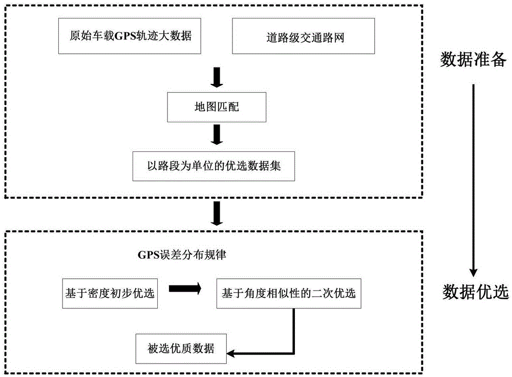
[0047] The technical scheme of the method of the present invention can adopt computer software to support the automatic operation process. see figure 1 A method for selecting data with higher positioning accuracy from low-precision mass vehicle-mounted GPS track data provided by an embodiment of the present invention includes the following steps:

[0048] 1) Based on the big data of the original vehicle-mounted GPS trajectory and the road-level traffic network, map matching processing is performed on the original GPS trajectory to determine the road section corresponding to each trajectory point, and then the original spatial position is not changed, and the corresponding road section on each road section is used. The GPS trajectory data of the GPS trajectory data is used as the optimization target, and the optimal data set ...


PUM


Abstract

Provided is a vehicle-mounted GPS space-time trajectory big data optimization method and system. The vehicle-mounted GPS space-time trajectory big data optimization method comprises the steps that map matching processing is performed according to original GPS trajectory data and a road-grade traffic network, and a road section corresponding to each trajectory point is determined; the initial optimization rate is determined according to a GPS trajectory error distribution law; preliminary optimization is performed based on density and includes the preliminary optimization performed according to a density evaluation model and the initial optimization rate, so that the trajectory points gathered on the road surfaces are selected, and the points away from the road surfaces are regarded as drifting points to be abandoned; secondary optimization is performed based on angle similarity and includes similarity value calculation conducted on preliminary optimization results by utilizing an angle similarity evaluation model, clustering processing is performed, then the results having highest similarity values in clustering categories are selected as final optimization results, and selected high-quality data are obtained. By means of the vehicle-mounted GPS space-time trajectory big data optimization method and system, overall positioning accuracy based on low-accuracy vehicle-mounted GPS trajectory big data is improved. The optimization method is simple and easy to achieve.

Description

technical field [0001] The invention relates to a technical solution for large data optimization of vehicle-mounted GPS spatio-temporal trajectories, which belongs to the research field of geographic information systems and intelligent transportation. Background technique [0002] Vehicle-mounted GPS space-time trajectory big data is an important data source for urban computing, traffic dynamic information acquisition, and human behavior pattern detection. Usually, big data refers to the collection of data that cannot be captured, managed and processed by conventional software tools within an acceptable time frame. It is directly proportional to the processing power of the computer. Big. At present, the big data of vehicle-mounted GPS spatio-temporal trajectory mainly comes from urban taxis equipped with GPS positioning devices and radio communication systems, and the collection results belong to single point positioning technology (SPP / GPS). At the same time, due to the i...

Claims


Application Information

Patent Timeline
Patent Type & Authority Applications(China)
IPC IPC(8): G06F17/50G01S19/42
Inventor 唐炉亮杨雪李清泉
Owner WUHAN UNIV
Why Eureka
Try Eureka