
Grid-based indoor area location and navigation method

A navigation method and inner area technology, applied in the indoor path calculation planning application, indoor positioning field, to achieve the effect of simplifying the navigation algorithm, saving investment, and widely popularizing and applying

Inactive Publication Date: 2015-12-23
上海赛图计算机科技股份有限公司
View PDF4 Cites 15 Cited by
  • Summary
  • Abstract
  • Description
  • Claims
  • Application Information

AI Technical Summary

Problems solved by technology

[0004] Aiming at the defect of current indoor positioning, the present invention proposes a new method for indoor large-grid area positioning, which only locates the terminal in the area and displays the positioning results in the form of area planes

Method used


Image

  • Grid-based indoor area location and navigation method

Examples


Embodiment Construction

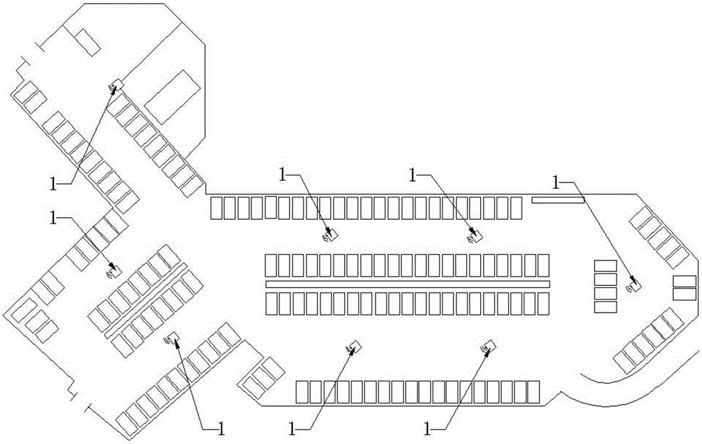
[0015] Combine below figure 1 The present invention will be further described in detail with examples, and the following examples are only descriptive, not restrictive, and cannot limit the protection scope of the present invention with this.

[0016] 1. Analyze the indoor terrain, combine the selected positioning method (Wi-Fi, Rfid, Bluetooth or hybrid positioning, etc.) and the parameter characteristics of the selected positioning device 1 (terminal), plan the equipment deployment plan; the deployment of the equipment meets the regional positioning That’s enough, so it can be deployed relatively sparsely, and the deployment plan can be planned and deployed by users according to the structure of functional areas, indoor terrain partitions, application requirements, and actual positioning fingerprint signals. The distribution of parking spaces in indoor parking lots is generally distributed along indoor roads, so the positioning device 1 can be deployed near indoor roads; rel...


PUM


Abstract

The invention discloses a grid-based indoor area location and navigation method. The method comprises the following sequential steps: analyzing an indoor terrain, primarily dividing an indoor area into a plurality of areas and deploying one or more location devices in each area; acquiring signal fingerprint information within the areas after the deployment is completed or in the deployment process, and adjusting the devices and the deployment positions of the devices and re-adjusting and dividing the areas through the obtained signal fingerprint information; after relatively fixed various location areas are formed, setting an unique ID value for each area and optionally binding each area with acquired signal fingerprint features; constructing a location platform; and constructing an electronic map application platform. The grid-based indoor area location and navigation method is capable of saving the investment needed to realize indoor location; meanwhile, in indoor path planning and navigation, the previous path analysis and navigation mode is changed and only path navigation between two planes from grid area to area needs to be realized; as a result, a navigation algorithm is simplified and the efficiency is improved.

Description

technical field [0001] The invention relates to indoor positioning, navigation and display methods, and belongs to the design analysis method in the application fields of indoor positioning and indoor route calculation and planning. Background technique [0002] In the field of indoor location service application, it mainly involves indoor positioning, display of positioning results, indoor path planning and navigation, etc. In the current various positioning applications and systems, the requirements for positioning accuracy are often relatively high, and there are few applications based on indoor location. Features to develop more easy-to-use solutions for positioning and related applications. Indoor positioning is not like outdoor GPS applications that can obtain positioning information for free through satellites. It is often necessary to build a platform for positioning signals required for positioning to achieve positioning, such as deploying Wi-Fi, Rfid, Bluetooth and...

Claims


Application Information

Patent Timeline
Patent Type & Authority Applications(China)
IPC IPC(8): H04W64/00H04W4/02
CPCH04W64/003H04W4/025
Inventor 张欣
Owner 上海赛图计算机科技股份有限公司
Learn More