Overground and underground integrated modeling method based on true 3D volumetric display technique and system

A modeling method and 3D model technology, applied in the 3D field, can solve problems such as unfavorable management and analysis, lack of attention, time-consuming and labor-intensive problems, and achieve the effects of saving manpower, simple structure, and avoiding losses

Inactive Publication Date: 2016-01-20
SHENZHEN POLYTECHNIC
View PDF3 Cites 10 Cited by
  • Summary
  • Abstract
  • Description
  • Claims
  • Application Information

AI Technical Summary

Problems solved by technology

However, none of these design methods can reflect the three-dimensional geographic coordinates of the underground pipe network, which is not conducive to spatial analysis, attribute query and visual management
[0008] 2. The two-dimensional GIS system built lacks three-dimensional information, which is not conducive to management and analysis
Two-dimensional GIS is only a simplified process of projecting all kinds of geographical objects in three-dimensional space to two-dimensional planes, resulting in the loss of geometric position information, spatial topology information and partial semantic information in the third dimension (ie, vertical direction). cannot fully reflect the objective world
[0010] 3. The above-ground and underground integrated modeling has not been carried out
[0012] 4. Only pay attention to the three-dimensional objects on the ground, not the three-dimensional shape of the un

Method used


Image

  • Overground and underground integrated modeling method based on true 3D volumetric display technique and system
  • Overground and underground integrated modeling method based on true 3D volumetric display technique and system
  • Overground and underground integrated modeling method based on true 3D volumetric display technique and system

Examples


Embodiment Construction

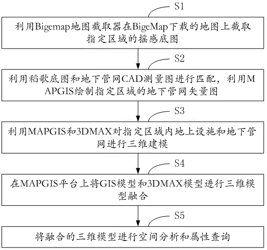
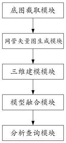
[0054] figure 1 It shows the flow chart of the modeling method based on the true three-dimensional above-ground and underground integration provided by the present invention, which is described in detail as follows:

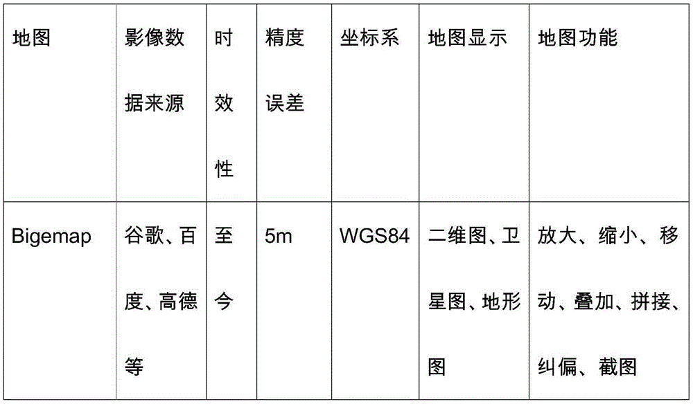
[0055] Step S1, use the Bigemap map extractor to intercept the remote sensing base map of the designated area on the map downloaded by BigeMap; download the map through "BigeMap map". The downloaded map of BigeMap has latitude and longitude, and the accuracy of the downloaded map of "Bigemap map" reaches 5 meters. Its accuracy error is relatively large. In order to make the accuracy error of the map smaller, the accuracy of the map downloaded by BigeMap is corrected through GPS data. After correction, the accuracy can reach 1 meter. Through the Bigemap map interceptor, the remote sensing base map of the campus is obtained on the corrected map. There is a certain error between the coordinates of the campus remote sensing base map of the Bigemap map interceptor a...


PUM


Abstract

The invention relates to the field of three-dimensional technology and provides an overground and underground integrated modeling method based on true 3D volumetric display technique. The modeling method comprises following steps of A: using a Bigemap map interception device to intercept a remote sensing bottom diagram in a designed area on a map downloaded from a Bigemap; B: matching a daogle bottom diagram with an underground pipe network CAD measurement graph and using a MAPGIS to draw an underground pipe network vector diagram of the designated area; C: using the MAPGIS and a 3DMAX to perform three-dimensional modeling for overground facilities and underground pipe networks in the designated area; D: performing three-dimensional model integration on a GIS model and a 3DMAX model on a MAPGIS platform; and E: performing space analysis and attribute searching on the integrated three-dimensional models. The modeling method is characterized and advantaged by simple structure, easy operation, low manufacturing cost and fine and smooth models, can be widely applicable for overground and underground integrated modeling in schools, communities, industrial zones and parks, and has high market promotion and application value.

Description

technical field [0001] The invention belongs to the field of three-dimensional technology, and in particular relates to a modeling method and system based on true three-dimensional ground-underground integration. Background technique [0002] Statistics show that more than 30% of the damage accidents of the underground pipeline system in the United States are caused by improper excavation. In this regard, the United States has established a GIS platform, and uses the GIS system for accurate management and positioning. American citizens can tell the diggers the detailed information of the pipeline as long as they dial the "811" special line. my country's pipeline construction was chaotic in the early stage, and the later maintenance was unsupervised, and road zippers appeared frequently. With the acceleration of my country's urbanization process, more and more road excavations are required. Water, gas, power and communication interruptions caused by construction damage to u...

Claims


Application Information

Patent Timeline
IPC IPC(8): G06T17/05
Inventor 袁媛向怀坤何惠琴
Owner SHENZHEN POLYTECHNIC
Why Eureka
Try Eureka