Measuring type unmanned ship and measuring method thereof

An unmanned boat and wireless technology, which is applied in the direction of unmanned surface ships, ships, underwater ships, etc., can solve the problems of hidden dangers in measurement work, inability to realize all-weather operations, and difficulty in erecting measurement equipment

Inactive Publication Date: 2016-01-27
TIANJIN BEIYANG LANSHUI TECH
View PDF5 Cites 18 Cited by
  • Summary
  • Abstract
  • Description
  • Claims
  • Application Information

AI Technical Summary

Problems solved by technology

However, the difficulty of operation in shallow water areas is much greater than that in deep water areas, and there are the following problems in actual operation: first, it is difficult to set up measuring equipment on small boats; second, small boats generally can only operate when the tide is high, and can

Method used


Image

  • Measuring type unmanned ship and measuring method thereof
  • Measuring type unmanned ship and measuring method thereof
  • Measuring type unmanned ship and measuring method thereof

Examples


Embodiment Construction

[0043] The present invention will be described in detail below with reference to the drawings and examples.

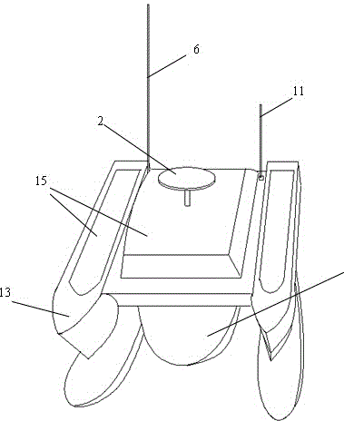
[0044] figure 1 It is a structural schematic diagram of the measuring type unmanned boat of the present invention;

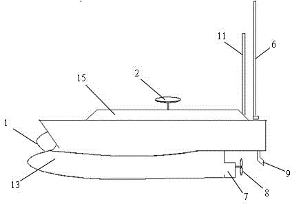
[0045] figure 2 It is a side view of the measuring type unmanned boat of the present invention;

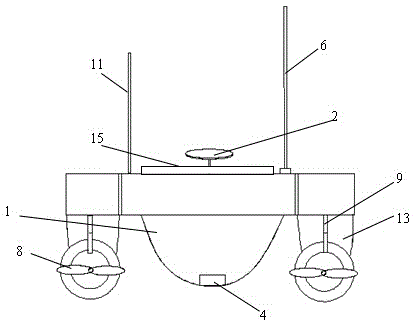
[0046] image 3 It is the rear view of the measuring type unmanned boat of the present invention

[0047] Figure 4 It is a connection schematic diagram of each device of the measuring type unmanned boat of the present invention.

[0048] Such as Figures 1 to 4 As shown, the measuring type unmanned boat of the present invention comprises the following structures:

[0049] The hull is a trimaran structure, which constitutes the hardware supporting platform of the unmanned boat. The main hull 1 in the middle is provided with a space-tight main cabin, and the floating bodies 3 on both sides increase the stability of the hull. Motors and propulsion devi...


PUM


Abstract

A measuring type unmanned ship comprises the following structures including a ship body, a GNSS mainframe, a depthometer and a wireless data transmission module, wherein the ship body forms a hardware bearing platform for the unmanned ship; a cabin with a sealed space is arranged in the ship body; the GNSS mainframe is used for detecting the current position of the unmanned ship; the depthometer is used for detecting the water depth in the current position of the unmanned ship; the wireless data transmission module is connected with a control device and used for transmitting the current position information and an equipment working state and receiving a control instruction. A measuring method of the measuring type unmanned ship comprises the following steps that the unmanned ship automatically measures a preset water area according to an instruction signal obtained by the control device and automatically matches the measured water depth data and corresponding position coordinates of measuring points; the water depth information and the position information are transmitted and backed up through the wireless data transmission module and a memory; after the measuring range is finished, multi-point water depth information of the water area can be obtained; and then the information is summarized to obtain water depth status and underwater topography status of the water area.

Description

technical field [0001] The invention relates to the technical field of hydrographic surveying and ocean monitoring, in particular to a surveying unmanned boat and a surveying method that automatically samples, surveys, maps or detects water depth and seabed topography in a set water area. Background technique [0002] At present, the projects and content of marine surveying and mapping are increasing, which puts forward higher and higher requirements for the research and development and application of surveying and mapping methods and technologies. In offshore bathymetric surveys, manual surveying and mapping is usually carried out by boat, line by line, and area by line. It is generally divided into two parts: one is the deep sea area far away from the shore (the water depth exceeds 15m); the other is the near-shore shallow sea area (the water depth is 0-15m). [0003] When working in deep sea areas, large ships (with a draft above 3.5m) are usually used to set up measurin...

Claims


Application Information

Patent Timeline
IPC IPC(8): B63G8/00
CPCB63B1/125B63B2035/007B63B2211/02B63J2003/003Y02T70/00
Inventor 孙雅林张安民曹维
Owner TIANJIN BEIYANG LANSHUI TECH
Why Eureka
Try Eureka