Car driving speed-limiting system based on GIS and running method of car driving speed-limiting system based on GIS

An active, automotive technology, applied in vehicle parts, transportation and packaging, input parameters of external conditions, etc., can solve problems such as not being able to implement speed limit or active braking in advance, not fully considering collaborative interaction, and adjusting values ​​accordingly. Strong real-time performance, high accuracy, and improving the effect of intelligence

Inactive Publication Date: 2016-02-24
SHANDONG UNIV OF SCI & TECH
View PDF6 Cites 12 Cited by
  • Summary
  • Abstract
  • Description
  • Claims
  • Application Information

AI Technical Summary

Problems solved by technology

However, this patent has the following defects: it does not fully consider the collaborative interaction of people, cars, roads and the environment
For example, the speed limit value cannot be adjusted accordingly according to signals such as the relative position of the car and the car, so when there is a danger of collision with the vehicle in front, the speed limit or active braking cannot be implemented in advance, which has certain potential safety hazards; The state of the traffic environment is dynamically changing, such as the relative position of vehicles, traffic flow density, and the radius of curvature of the specific road section trajectory. Corresponding corrections to ensure the real-time and accuracy of the speed limit value and improve the intelligence of the speed limit system

Method used


Image

  • Car driving speed-limiting system based on GIS and running method of car driving speed-limiting system based on GIS
  • Car driving speed-limiting system based on GIS and running method of car driving speed-limiting system based on GIS

Examples


Embodiment 1

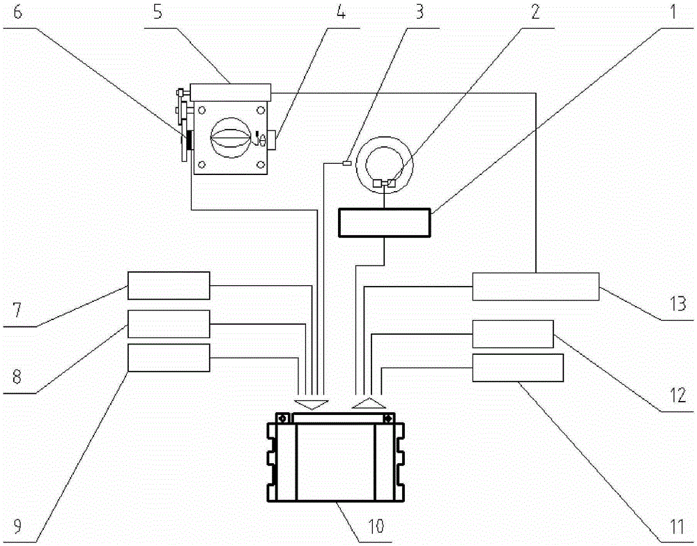
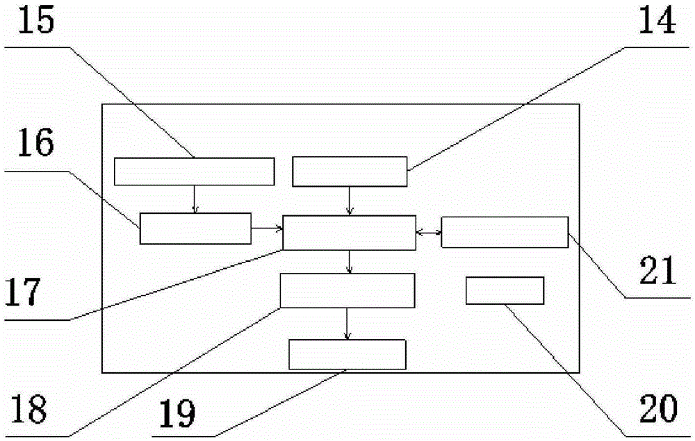
[0051] A GIS-based automobile active speed limit system, comprising information collection equipment, a GIS speed limit value control unit 10, an output display terminal, and an actuator, the input end of the GIS speed limit value control unit 10 is connected to the information collection device, The output end of the GIS speed limit value control unit 10 is respectively connected to the output display end and the actuator;

[0052] The information collection device is used to: perceive the distance to the vehicle in front, the current vehicle speed, and the current vehicle throttle position information; collect the current vehicle positioning information; display and update the static road network information in time;

[0053] The GIS speed limit value control unit 10 is used to: extract the initial speed limit value and road characteristic parameters of the current road section according to the current vehicle positioning information and static road network information, combi...

Embodiment 2

[0071] The operating method of the GIS-based automobile active speed limiting system described in embodiment 1, the specific steps include:

[0072] (1) The GPS receiver 7 collects the current vehicle positioning information in real time, the navigator 8 displays in real time and updates the static road network information in time, and the current vehicle positioning information and the static road network information are sent to the GIS data storage unit 15, Simultaneously, the current vehicle positioning information is sent to the map display screen 12 for display; the ultrasonic sensor 9 senses the distance d with the vehicle ahead in real time; the throttle position sensor 6 senses the current vehicle throttle position information α in real time; the wheel speed sensor 3 Real-time perception of the running speed v of the current vehicle, the analog signals sent by the ultrasonic sensor 9, the throttle position sensor 6, and the wheel speed sensor 3 are sent to the signal ac...


PUM


Abstract

The invention relates to a car driving speed-limiting system based on the GIS and a running method of the car driving speed-limiting system based on the GIS. The car driving speed-limiting system comprises an information collecting device, a GIS speed-limiting control unit, an output display end and an execution device; the information collecting device senses the distance between a car and a car in the front, the running speed of the current car and the throttle position information of the current car, collects positioning information of the current car and displays and updates static state road network information in real time; the GIS speed-limiting control unit extracts the initial speed-limiting value and the road characteristic parameter of a current road section according to the positioning information of the current car and the static state road network information, amends the initial speed-limiting value in combination with the distance between the car and the car in the front and the road characteristic parameter, obtains the best speed-limiting value, obtains the maximum allowing throttle percentage value through conversion and limits the car speed of the car. According to the car driving speed-limiting system and the running method, the speed-limiting values of the car in all road sections will be continuously adjusted along with changes of the road condition, the car cannot exceed the maximum speed-limiting value in the road section even though a driver does any operation, and the running safety is guaranteed.

Description

technical field [0001] The invention relates to a GIS-based automobile active speed limiting system and an operating method thereof, belonging to the technical field of automobile safety auxiliary driving. Background technique [0002] Traffic safety has always been a key area of ​​traffic management. The occurrence of various traffic accidents is mostly because the speed of the vehicle is too fast and the driving is out of control, which eventually leads to tragedy. In the field of active safety control and assisted driving of automobiles, it is necessary to develop a control system that can limit the speed of automobiles in real time based on comprehensive road condition information. [0003] At present, the intelligent speed limit system is mainly invented to improve the accuracy of speed limit sign recognition and generate early warning signals in time, including a navigator, which can identify road traffic signs; and use image processing technology to extract road traf...

Claims


Application Information

Patent Timeline
Patent Type & Authority Applications(China)
IPC IPC(8): B60W30/14
CPCB60W30/146B60W2510/0604B60W2520/10B60W2552/15B60W2552/30B60W2554/00B60W2554/801B60W2710/0605B60W2710/182
Inventor 刘志海杨凯迪曾庆良张荣华张丹丹王成龙闫成稳江守波王认辉
Owner SHANDONG UNIV OF SCI & TECH
Why Eureka
Try Eureka