Marsh wetland mapping method based on object-oriented random forest classification method and medium-resolution remote sensing image

A random forest, object-oriented technology, applied in special data processing applications, instruments, electrical digital data processing, etc., can solve the problem of inaccurate extraction of grass swamp, scrub swamp and forest swamp spatial information, etc. The effect of clarifying geographic significance

Inactive Publication Date: 2016-03-16
NORTHEAST INST OF GEOGRAPHY & AGRIECOLOGY C A S
View PDF4 Cites 28 Cited by
  • Summary
  • Abstract
  • Description
  • Claims
  • Application Information

AI Technical Summary

Problems solved by technology

[0006] The purpose of the present invention is to solve the technical problem that the current remote sensing classification method can not accurately extract the spatial information of grass swamp, shrub swamp and forest swamp by only using spectral information, and provides an object-oriented-random forest classification method and medium Distinguishing Method of Grassy Swamp, Shrub Swamp and Forest Swamp Based on Resolution Remote Sensing Image

Method used


Image

  • Marsh wetland mapping method based on object-oriented random forest classification method and medium-resolution remote sensing image
  • Marsh wetland mapping method based on object-oriented random forest classification method and medium-resolution remote sensing image
  • Marsh wetland mapping method based on object-oriented random forest classification method and medium-resolution remote sensing image

Examples


specific Embodiment approach 1

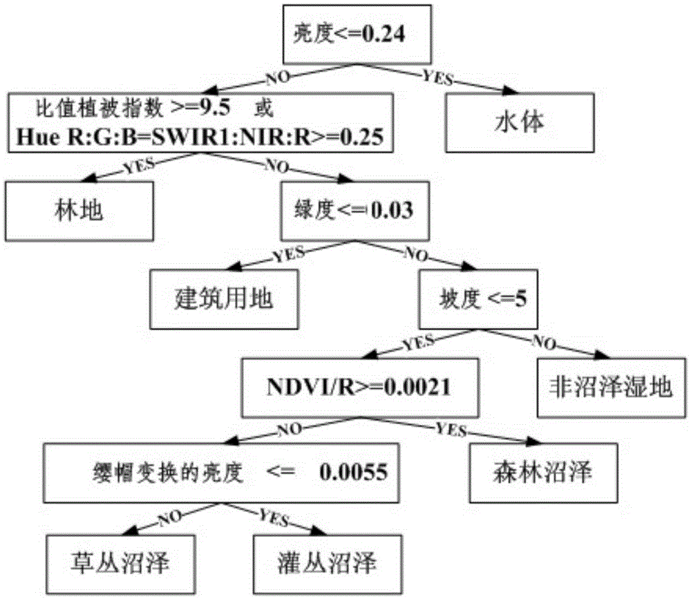
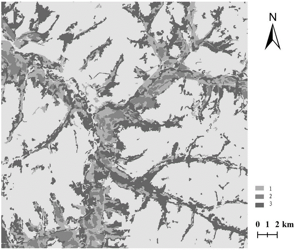
[0046] Specific implementation mode one: the method for swamp wetland mapping based on the object-oriented-random forest classification method and medium-resolution remote sensing images of this embodiment is carried out according to the following steps:

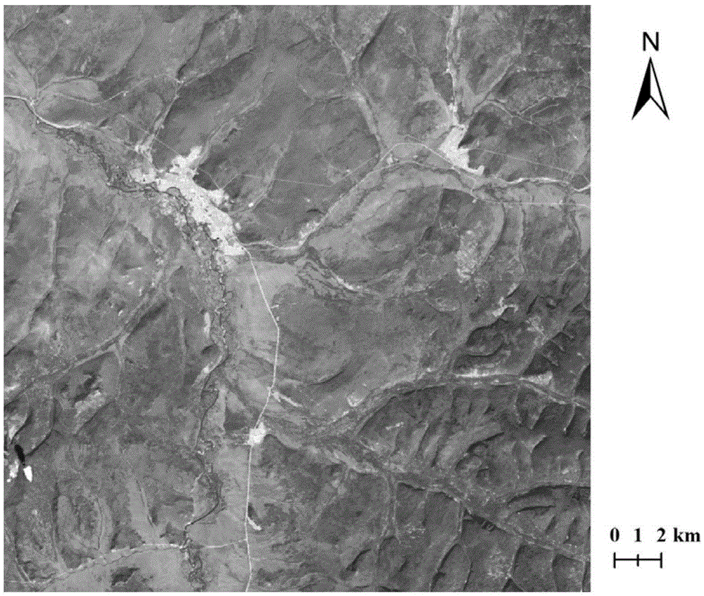
[0047] 1. Carry out radiometric calibration, atmospheric correction, orthorectification, geometric fine correction and projection transformation on Landsat-8OLI data;

[0048] 2. Collect slope, topographic humidity index based on digital elevation model (DEM) and brightness, greenness and humidity auxiliary data obtained based on tasseled cap transformation;

[0049]3. With the support of eCognition8.64 software, the Landsat-8OLI image and auxiliary classification data are segmented into multiple layers and multi-scales. The eCognition8.64 software comes with a multi-scale segmentation algorithm, which can divide the remote sensing image into a series of homogeneous units, namely Object, to obtain a series of segmentation un...

specific Embodiment approach 2

[0079] Embodiment 2: The difference between this embodiment and Embodiment 1 is that the Landsat-8OLI data in Step 1 is that the track number is P122R23, and the time is August 31, 2015. Other steps and parameters are the same as those in the first embodiment.

specific Embodiment approach 3

[0080] Specific embodiment three: the difference between this embodiment and specific embodiment one is that in step one, radiation calibration, atmospheric correction, orthorectification, geometric precision correction and projection conversion are carried out as follows: use ENVI5.1 software The FLAASH module performs atmospheric correction on the Landsat-8OLI image; uses the DEM data of the test area to perform orthorectification on the atmospherically corrected image; in order to eliminate geometric distortion, use the 1:50000 terrain data to select the ground control points in the ERDAS9.2 software, Perform geometric fine correction on the orthorectified image. Other steps and parameters are the same as those in the first embodiment.


PUM


Abstract

The present invention relates to a marsh wetland mapping method based on an object-oriented random forest classification method and a medium-resolution remote sensing image. The purpose of the present invention is to solve the technical problem that a current remote sensing classification method can not accurately extract spatial information of a tussock marsh, a shrub marsh and a forest marsh only by using of spectral information. The marsh wetland mapping method provided by the present invention comprises: carrying out radiometric calibration, atmospheric correction, ortho-rectification, accurate geometric correction and projective conversion by using Landsat-80LI data; processing the data by using eCognition 8.6 software; removing non-marsh wetland objects from marsh wetland objects; setting an index threshold region to separate the tussock marsh, the shrub marsh and the forest marsh; and then mapping a thematic marsh wetland map in ArcGIS 10.0 software. The marsh wetland mapping method provided by the present invention is high in accuracy. The marsh wetland mapping method provided by the present invention is applied to marsh wetland mapping.

Description

technical field [0001] The invention relates to a method for making marsh wetland mapping by using remote sensing images. Background technique [0002] Wetlands are the ecosystems with the highest ecological service value per unit area, the strongest carbon sequestration capacity, and the greatest significance for biodiversity protection on the earth. They are known as the "kidney of the earth". Marsh wetland (Marsh Wetland) is the main type of wetland, including grass swamp, shrub swamp and forest swamp. It has many functions such as water conservation, flood storage and drought prevention, degradation of pollution, maintenance of biodiversity, regulation of river runoff and local climate, replenishment of groundwater, purification of the environment, deposition of nutrients, and prevention of soil erosion; swamp wetlands can also provide human Food, fruit, medicine, energy and a variety of industrial raw materials; the food chain in the swamp and the biodiversity it suppo...

Claims


Application Information

Patent Timeline
Patent Type & Authority Applications(China)
IPC IPC(8): G06F17/50
CPCG06F30/18
Inventor 满卫东王宗明刘明月贾明明毛德华任春颖路春燕欧阳玲于皓
Owner NORTHEAST INST OF GEOGRAPHY & AGRIECOLOGY C A S
Why Eureka
Try Eureka