Method and device of pavement identification on the basis of laser-point cloud

A laser point cloud and point cloud technology, applied in character and pattern recognition, image data processing, 3D modeling, etc., can solve the problems of low accuracy of road surface models and inability to filter out noise, so as to filter out noise and improve accuracy. sexual effect

Active Publication Date: 2016-05-04
BAIDU ONLINE NETWORK TECH (BEIJIBG) CO LTD
View PDF3 Cites 30 Cited by
  • Summary
  • Abstract
  • Description
  • Claims
  • Application Information

AI Technical Summary

Problems solved by technology

Vegetation, trees or road signs become the noise of road surface laser point cloud data, and because there is no effective method to distinguish noise from useful road surface point cloud data, these noises cannot be filtered out, resulting in low accuracy of the currently constructed road surface model

Method used


Image

  • Method and device of pavement identification on the basis of laser-point cloud
  • Method and device of pavement identification on the basis of laser-point cloud
  • Method and device of pavement identification on the basis of laser-point cloud

Examples


Embodiment 1

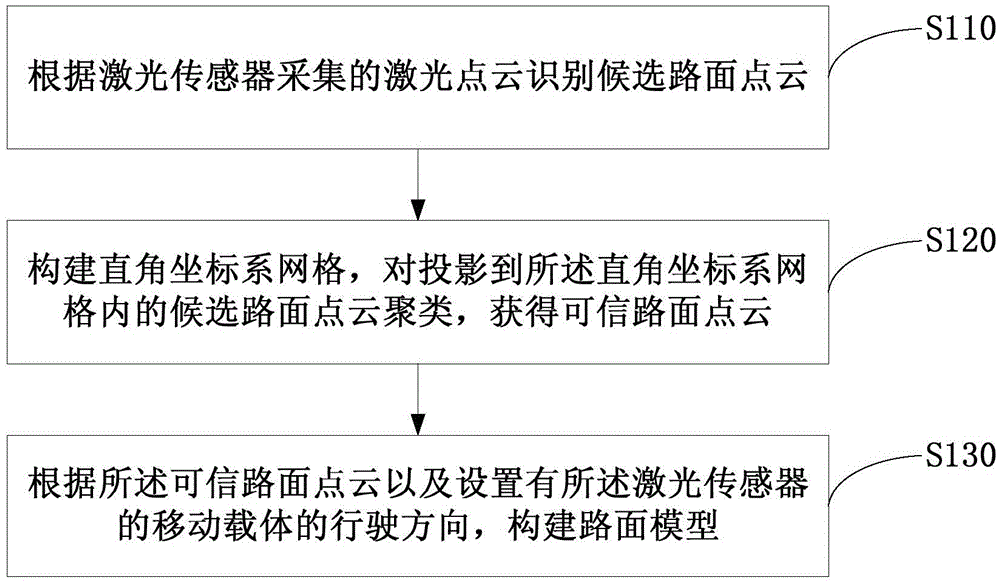
[0021] figure 1 It is a schematic flow chart of the laser point cloud-based road surface recognition method provided by Embodiment 1 of the present invention. This embodiment is applicable to the situation of constructing an accurate road surface model based on the laser point cloud collected by the laser sensor. The method can be executed by a laser point cloud-based road surface recognition device, which can be implemented by means of hardware and / or software, and can generally be integrated into a server for mapping roads.

[0022] see figure 1 , the laser point cloud-based road surface recognition method provided in this embodiment may specifically include the following:

[0023] S110. Identify candidate road surface point clouds according to the laser point clouds collected by the laser sensor.

[0024] The laser sensor is set on the mobile carrier and collects the laser point cloud of the current road surface at regular intervals. Wherein, the mobile carrier may be a...

Embodiment 2

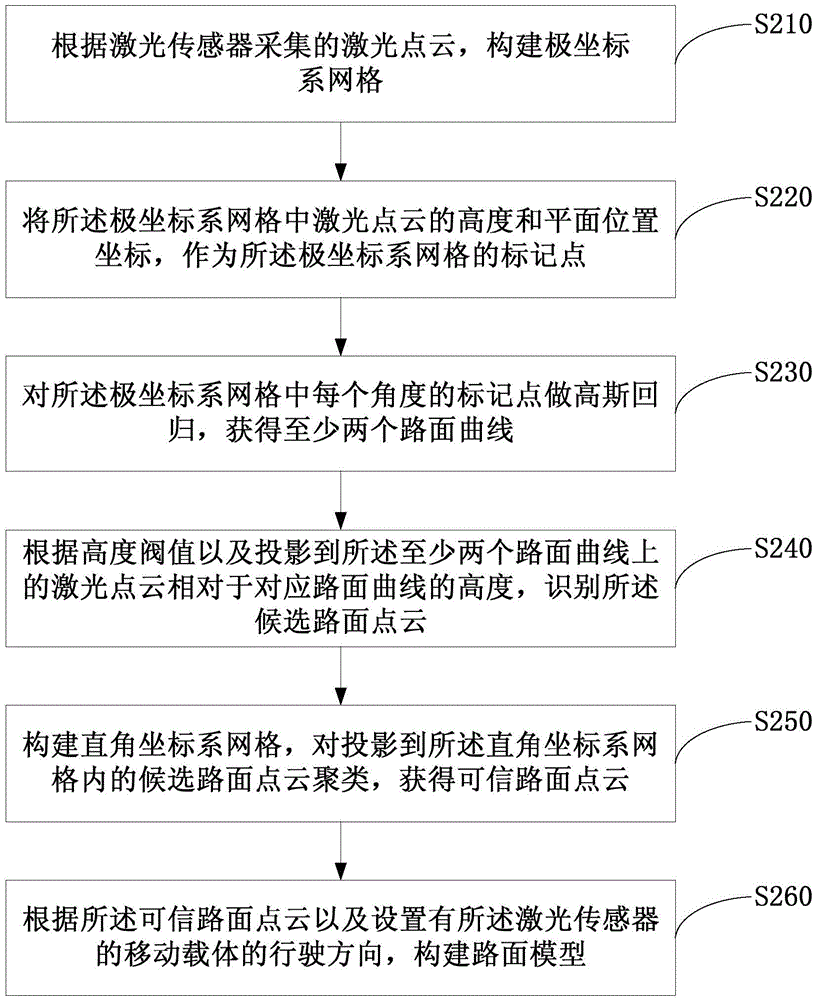
[0031] This embodiment provides a road surface recognition method based on a laser point cloud on the basis of the first embodiment above. figure 2 It is a schematic flow chart of the laser point cloud-based road surface recognition method provided by Embodiment 2 of the present invention. like figure 2 As shown, the laser point cloud-based road surface recognition method provided in this embodiment may specifically include the following:

[0032] S210. Construct a polar coordinate system grid according to the laser point cloud collected by the laser sensor.

[0033] For each frame of laser point cloud, with the current position of the mobile carrier provided with the laser sensor as the origin, a polar coordinate system grid is respectively constructed, so that the range of the polar coordinate system grid covers the frame of laser point cloud.

[0034] S220. Using the height and plane position coordinates of the laser point cloud in the polar coordinate system grid as ma...

Embodiment 3

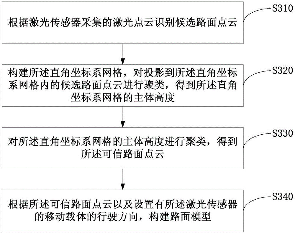
[0044] This embodiment provides a road surface recognition method based on laser point cloud on the basis of the above embodiments. image 3 It is a schematic flow chart of the laser point cloud-based road surface recognition method provided by Embodiment 3 of the present invention. Such as image 3 As shown, the laser point cloud-based road surface recognition method provided in this embodiment may specifically include the following:

[0045] S310. Identify candidate road surface point clouds according to the laser point clouds collected by the laser sensor.

[0046] S320. Construct the Cartesian coordinate system grid, cluster the candidate road surface point clouds projected into the Cartesian coordinate system grid, and obtain the body height of the Cartesian coordinate system grid.

[0047] Taking the current position of the mobile carrier provided with the laser sensor as the origin, and the current traveling direction of the mobile carrier as the vertical axis, a Cart...


PUM


Abstract

The present invention discloses a method and device of pavement identification on the basis of a laser-point cloud. The method provided by the invention comprises: identifying candidate pavement point clouds according to the laser-point cloud collected by a laser sensor; constructing a rectangular coordinate system grid, clustering a candidate pavement point cloud projected to the rectangular coordinate system grid, and obtaining a credible pavement point cloud; and constructing a pavement model according to the credible pavement point cloud and the driving direction of a mobile carrier provided with the laser sensor. Through the technical scheme provided by the embodiment of the invention, a candidate pavement point cloud is identified according to the laser-point cloud collected by a laser sensor, a credible pavement point cloud is obtained by clustering the candidate pavement point cloud projected to the rectangular coordinate system grid, and finally a pavement model is constructed according to the credible pavement point cloud and the driving direction of a mobile carrier provided with the laser sensor, therefore the noise in a pavement laser-point cloud is effectively filtered and the accuracy of the construction of the pavement model is improved.

Description

technical field [0001] Embodiments of the present invention relate to the field of geographic information data processing, in particular to a method and device for road surface recognition based on laser point clouds. Background technique [0002] The accurate construction of the road surface model in the electronic map is helpful for service providers to provide users with better experience. [0003] At present, road surface models are mainly constructed based on laser point clouds. When laser sensors are used to collect relevant point cloud data, the laser light returned from the surface of the object only carries the surface information of the object. Therefore, the road surface information covered by vegetation, trees or road signs, etc. is not included in the collected point cloud data. Vegetation, trees or road signs become the noise of road surface laser point cloud data, and because there is no effective method to distinguish noise from useful road surface point clo...

Claims


Application Information

Patent Timeline
Patent Type & Authority Applications(China)
IPC IPC(8): G06T17/05G06K9/00
CPCG06T17/05G06T2207/10028G06T2207/30184G06V20/56
Inventor 姜雨晏阳关书伟蒋昭炎
Owner BAIDU ONLINE NETWORK TECH (BEIJIBG) CO LTD
Why Eureka
Try Eureka