Geographical location information acquiring method based on MLS

A technology of geographic location information and acquisition method, which is applied in the field of angle measurement and ranging information of microwave landing system and land-based navigation system, and can solve problems such as being susceptible to interference, abnormal real-time status signals, and deterioration of location information accuracy

Active Publication Date: 2016-05-11
NO 20 RES INST OF CHINA ELECTRONICS TECH GRP
View PDF6 Cites 5 Cited by
  • Summary
  • Abstract
  • Description
  • Claims
  • Application Information

AI Technical Summary

Problems solved by technology

The use of satellite navigation receivers, especially in combination with the use of differential enhanced information, can enable airborne equipment to obtain extremely high geographic location accuracy (after using real-time carrier phase difference technology, the positioning accuracy can reach centimeter level), but the satellite navigation system exists Vulnerability and integrity issues
The so-called "vulnerability" refers to the easy interference problem of the satellite navigation system. Because the distance between the satellite and the ground is too far, the signal reaching the ground is very weak and is easily interfered; the so-called integrity problem refers to the difficulty of the satellite navigation receiver to judge The real-tim

Method used


Image

  • Geographical location information acquiring method based on MLS
  • Geographical location information acquiring method based on MLS
  • Geographical location information acquiring method based on MLS

Examples


Embodiment Construction

[0026] The present invention will be further described below in conjunction with the accompanying drawings and embodiments, and the present invention includes but not limited to the following embodiments.

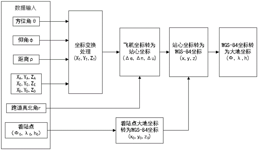
[0027] The present invention proposes a method for acquiring geographic position information based on MLS, comprising the following steps:

[0028] (1) Obtain MLS measurement information and airport information, as follows:

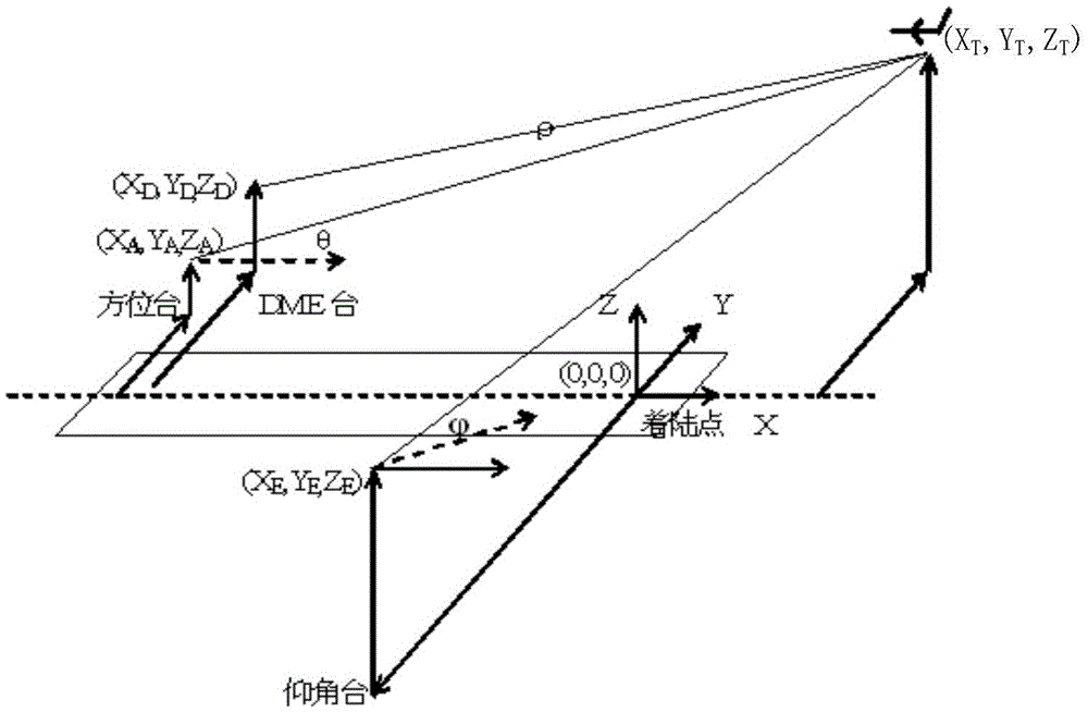
[0029] a) Establish the MLS system coordinate system. refer to figure 2 , establish a Cartesian coordinate system with the landing point of the runway as the origin, the X-axis and the Y-axis as the horizontal plane, the X-axis of the coordinate system is selected on the extension line of the runway center, and the negative value indicates the direction to the end of the runway.

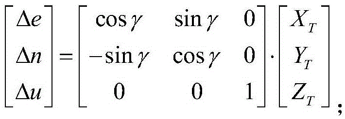
[0030] b) Obtain the coordinates of the antenna phase centers of the azimuth station, elevation station and rangefinder station in the MLS system coordinate system in the ...


PUM


Abstract

The invention provides a geographical location information acquiring method based on MLS. The method includes: acquiring MLS measuring information and airport information, and using a rotary Gauss-Legendre iteration algorithm to acquire the position of a plane in an MLS coordinate system if the MLS measuring information and the airport information are valid; or else continuing acquiring; calculating the coordinates of the plane in a geodetic coordinate system. The method has the advantages that the vulnerability and integrity problems caused by the fact that a satellite navigation receiver is affected by satellite signals can be avoided, the problem that precision shifts along with time due to the fact that an inertial navigation calculation method is used can be also avoided, and the reliability of geographical location information output of airborne equipment is guaranteed.

Description

technical field [0001] The invention belongs to the field of navigation, and relates to a land-based navigation system, in particular to a method for obtaining geographical position information (latitude, longitude and height) by using angle measurement and distance measurement information of a microwave landing system (MLS). Background technique [0002] The Microwave Landing System (MLS) is a new generation of aircraft precision approach guidance landing system. The typical ground equipment consists of azimuth, elevation and range measuring stations, which provide the azimuth relative to the azimuth station for the airborne equipment respectively. Elevation The elevation angle of the station and the distance relative to the ranging station. The azimuth station and the ranging station are generally erected at the same site and are located at the rear end of the runway exit; the elevation station is erected on the side of the runway entrance; all stations face the landing di...

Claims


Application Information

Patent Timeline
IPC IPC(8): G01C21/20
CPCG01C21/20
Inventor 赵建伟钟兴泉高新国董加成肖作民
Owner NO 20 RES INST OF CHINA ELECTRONICS TECH GRP
Why Eureka
Try Eureka