High-rise building fire positioning system and high-rise building fire positioning method
A high-rise building, positioning system technology, applied in radio wave measurement system, image data processing, electromagnetic wave re-radiation and other directions, can solve problems such as building collapse, property loss, property loss, etc.
- Summary
- Abstract
- Description
- Claims
- Application Information
AI Technical Summary
Problems solved by technology
Method used
Image
Examples
Embodiment 1
[0043] Such as figure 1 As shown, the present invention provides a kind of high-rise building fire location system, comprising:
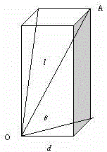
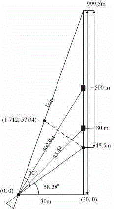
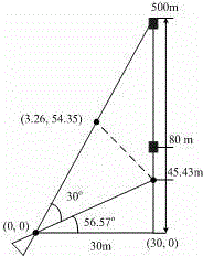
[0044]The detector 1 comprises a laser rangefinder 11, a thermal imager 12 and a visible light camera 13, wherein the laser rangefinder 11 is used to measure the distance information of a fire point; the thermal imager 12, It is used to detect the temperature field distribution of the fire point and take infrared images in the field of view; the visible light camera 13 is used to take high frame rate visible light images of the fire point, and the laser rangefinder can use a small high-precision laser The range finder can achieve a distance measurement accuracy of 0.1m in the range of 1Km; the infrared thermal imager can be an infrared imager based on an uncooled long infrared focal plane detector, such as an uncooled long infrared focal plane detector in the 8-14μm band The focal plane detector, which does not require an external refrigeration dev...
Embodiment 2
[0105] The present invention also provides another high-rise building fire location method, using the high-rise building fire location system of the first embodiment above, the method comprising:
[0106] Step S1, the human-computer interaction module sends an instruction to adjust the optical axis of the detector to the fire point to the two-dimensional adjustment base;
[0107] Step S2, the two-dimensional adjustment base adjusts the optical axis of the detector to point to the fire point according to the instruction of the human-computer interaction module;
[0108] Step S3, the laser range finder measures the distance information of the fire point, the infrared thermal imager detects the temperature field distribution of the fire point and takes an infrared image in the field of view, and the visible light camera takes a picture of the fire point High frame rate visible light images;
[0109] Step S4, the information fusion and processing module obtains the distance infor...
PUM
 Abstract
Description
Claims
Application Information
 - R&D
- Intellectual Property
- Life Sciences
- Materials
- Tech Scout
- Unparalleled Data Quality
- Higher Quality Content
- 60% Fewer Hallucinations
Browse by: Latest US Patents, China's latest patents, Technical Efficacy Thesaurus, Application Domain, Technology Topic, Popular Technical Reports.
© 2025 PatSnap. All rights reserved.Legal|Privacy policy|Modern Slavery Act Transparency Statement|Sitemap|About US| Contact US: help@patsnap.com


