Multi-sensing wireless information measurement and control system for deep geotechnical investigation

A measurement and control system and multi-sensing technology, applied in the field of engineering survey, can solve problems such as time-consuming operation, increased operation difficulty, joint damage, etc., to achieve the effects of ensuring safety, reducing engineering costs, and improving speed and accuracy

Inactive Publication Date: 2016-05-25
TIANJIN POLYTECHNIC UNIV
View PDF4 Cites 1 Cited by
  • Summary
  • Abstract
  • Description
  • Claims
  • Application Information

AI Technical Summary

Problems solved by technology

However, at present, the most commonly used drilling method and static penetration method in geotechnical engineering investigation have some inherent defects, which cannot meet the current engineering needs. The main measurement parameter of geotechnical static penetration is the probe penetration resistance. and the resistance of the side wall of the probe, without considering that the penetration resistance of the probe is affected by various factors such as the temperature of the probe and the verticality of the probe, resulting in large errors in the subsequent soil mechanics analysis; Sometimes multiple operators need to pass tens of meters of cables through each 1-meter-long penetration drill pipe, so the operation is time-consuming and laborious, and it is easy to damage the cables when adding or removing the drill pipe thread, resulting in Poor insulation, damaged connectors, which can make handling more difficult

Method used


Image

  • Multi-sensing wireless information measurement and control system for deep geotechnical investigation
  • Multi-sensing wireless information measurement and control system for deep geotechnical investigation
  • Multi-sensing wireless information measurement and control system for deep geotechnical investigation

Examples


Embodiment Construction

[0021] The multi-sensor wireless information measurement and control system for deep geotechnical investigation provided by the present invention will be described in detail below in conjunction with the accompanying drawings and specific embodiments.

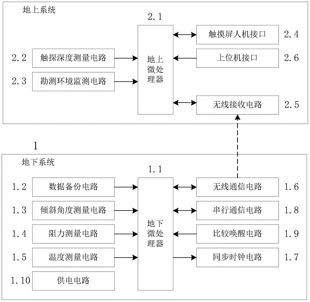
[0022] like figure 1 As shown, the multi-sensor wireless information measurement and control system for deep geotechnical survey provided by the present invention includes:

[0023] Underground system 1 and aboveground system 2, wherein: underground system 1 is set inside the first hollow steel probe rod connected with the penetrating probe, and is used to measure the resistance of the probe cone tip, the resistance of the side wall of the cone rod, and the soil layer Multi-sensing information including temperature, humidity, and cone rod inclination can realize data backup and wireless transmission tasks; the ground system 2 is set on the ground penetrating rod spinning loading bracket, fixed by a special fixture, and used to ...


PUM


Abstract

The invention discloses a multi-sensing wireless information measurement and control system for deep geotechnical investigation. The multi-sensing wireless information measurement and control system comprises an underground system and a ground system, wherein the underground system is wirelessly connected with the ground system. The multi-sensing wireless information measurement and control system aims to the field of geotechnical engineering investigation, on one hand, on the premise that the cableless requirement of static deep spinning touch is met, multiple soil mechanic parameters such as the cone tip resistance, the probe side wall resistance, the inclination and the temperature when a touch probe is fed, and survey environment information can be acquired and stored in real time due to design of the underground system; on the other hand, due to design of a low power consumption wireless transmission module, the ground system and corresponding interface circuits, wireless transmission synchronous correction and intelligent processing, backup and uploading of deep geotechnical investigation information and survey depth can be achieved, so that the speed of deep geotechnical investigation is accelerated, the precision of deep geotechnical investigation is improved, and the effects of lowering the engineering cost and ensuring the construction project safety can be achieved.

Description

technical field [0001] The invention belongs to the technical field of engineering survey, in particular to a multi-sensor wireless information measurement and control system for deep rock and soil survey. Background technique [0002] Geotechnical engineering survey is an important link in engineering construction. The accuracy and efficiency of the survey will directly affect the quality and cost of the building, and it is the premise guarantee for the safety and stability of the building. In recent years, with the continuous increase in the height of housing and commercial buildings in my country and the continuous increase in investment in infrastructure such as highways and high-speed railways, higher requirements have been put forward for the accuracy and efficiency of engineering surveys in construction. However, currently the most commonly used drilling method and static penetration method in geotechnical engineering investigation have some inherent defects, which ca...

Claims


Application Information

Patent Timeline
Patent Type & Authority Applications(China)
IPC IPC(8): G08C17/02
CPCG08C17/02
Inventor 郗涛张宏杰林志清
Owner TIANJIN POLYTECHNIC UNIV
Why Eureka
Try Eureka