Radar position selection method based on three dimensional laser scanner and GIS (Geographic Information System)

A technology of three-dimensional laser and radar positions, which is applied in the field of survey and selection of radar positions, can solve the problems of inability to meet the actual application requirements, inaccurate topography, sparse data points, etc., and achieve the goal of improving work efficiency, reducing dependence and realizing automation Effect

Inactive Publication Date: 2016-06-08
INST OF RADAR & ELECTRONICS CONFRONTATION ARMY AIR FORCE EQUIP RES INST OF PLA
View PDF2 Cites 20 Cited by
  • Summary
  • Abstract
  • Description
  • Claims
  • Application Information

AI Technical Summary

Problems solved by technology

[0005] The disadvantage of the above measurement method is that the measurement speed is slow and the data rate is low. It takes 1 day to complete the measurement of a position cover and the main combat direction section, and it takes about 3 people*1 month to complete the fine measurement of a position terrain; At the same time, the measured data points are sparse, and the measured topography is not accurate enough to meet the needs of practical applications.

Method used


Image

  • Radar position selection method based on three dimensional laser scanner and GIS (Geographic Information System)
  • Radar position selection method based on three dimensional laser scanner and GIS (Geographic Information System)
  • Radar position selection method based on three dimensional laser scanner and GIS (Geographic Information System)

Examples


Embodiment Construction

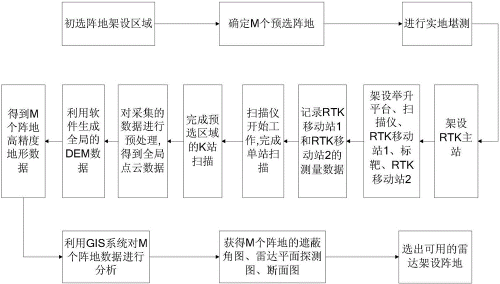
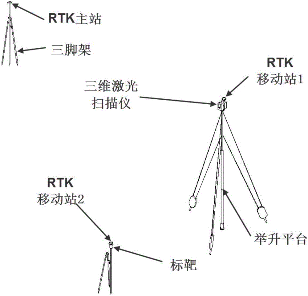
[0034] The invention adopts a three-dimensional laser scanner to collect the data of the position topography. 3D laser scanning technology, also known as real scene replication technology, is a technological revolution in the field of surveying and mapping after GPS technology. It breaks through the traditional single-point measurement method and has the unique advantages of high efficiency and high precision. 3D laser scanning technology can provide 3D point cloud data on the surface of the scanned object. It uses high-speed laser scanning measurement method to quickly obtain the 3D coordinate data of the surface of the measured object in a large area with high resolution, and can quickly and massively collect spatial points. information, so it can be used to obtain high-precision and high-resolution digital models. The three-dimensional laser scanner adopted in the present invention has a scanning radius of more than 1000 meters (20% reflectivity), and for a terrain to be m...


PUM


Abstract

A radar position selection method based on a three dimensional laser scanner and a GIS (Geographic Information System) is characterized in that the three dimensional laser scanner and a portable lifting platform are adopted, auxiliary devices such as an RTK and a target are matched for use, position three dimensional point cloud data can be quickly and accurately got, and high-precision DEM data are generated after data processing; on this basis, a skyline tool with a three dimensional space analysis function of the GIS is used to generate a skyline, then heights of various points of the skyline are extracted according to the skyline and imported topographic data, shielding angle data are generated, and a radar shielding angle figure and a radar plane detection range figure are generated according to the shielding angle data and radar parameters; a sight line analysis tool of the GIS is used to generate a visible line in a certain direction at an observation point, heights of various points of the visible line are extracted according to the visible line and the imported topographic data, so as to generate a cross-section diagram, undulation of a radar reflection area is analyzed, quantified undulation data are obtained, and a proper radar position erection location is favorably selected on this basis.

Description

technical field [0001] The invention belongs to the field of electronic measurement and relates to a method for surveying and selecting radar positions. Background technique [0002] The detection power of the radar not only depends on the performance parameters of the radar itself, but also depends on the geographical environment of the radar position. Factors such as ground object shading and surface reflection will cause a large difference between the actual lobe and the ideal lobe of the radar. Among them, the ground object Shading will affect the horizontal detection range of the radar, and the vertical lobe split caused by the ground reflection will increase or decrease the detection range of the radar, which will affect the high precision of the radar's low-altitude measurement. [0003] With the development of technology, the new generation of radar has put forward higher requirements for the terrain conditions of the site, requiring a smaller shading angle and a lar...

Claims


Application Information

Patent Timeline
Patent Type & Authority Applications(China)
IPC IPC(8): G01C15/00G06F17/50
CPCG01C15/002G06F30/367
Inventor 才长帅李光伟闫海高其嘉曹原王晓莉陈京平李建勋冀鑫炜石海天刘建平李静
Owner INST OF RADAR & ELECTRONICS CONFRONTATION ARMY AIR FORCE EQUIP RES INST OF PLA
Why Eureka
Try Eureka