Monocular vision ranging method based on edge point information in image

A visual odometry and edge point technology, which is applied in the field of UAV navigation and positioning, can solve the problems of inability to adapt to scenes lacking corner features, repetitive structures, and scarcity of numbers, etc., to enhance environmental adaptability, reduce dependence, The effect of reducing the amount of calculation

Active Publication Date: 2016-07-27
TSINGHUA UNIV
View PDF6 Cites 44 Cited by
  • Summary
  • Abstract
  • Description
  • Claims
  • Application Information

AI Technical Summary

Problems solved by technology

The existing monocular vision odometry methods generally use the corner features in the image to match between frames, which cannot adapt to scenes lacking corner features (the corner feature is an important feature of the image, representing the image in a certain Pixels that stand out in terms of some attributes
exist figure 1 In the scene in , corner features mostly appear at the intersection of straight lines, the number is rare and the structure is repetitive, and the existing monocular vision odometry algorithm based on corner features will likely fail)

Method used


Image

  • Monocular vision ranging method based on edge point information in image
  • Monocular vision ranging method based on edge point information in image
  • Monocular vision ranging method based on edge point information in image

Examples


Embodiment Construction

[0024] The present invention will be described in detail below in conjunction with the accompanying drawings and embodiments.

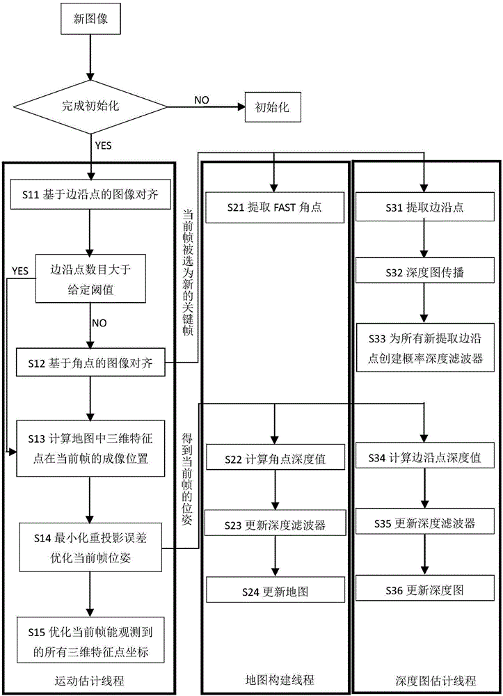
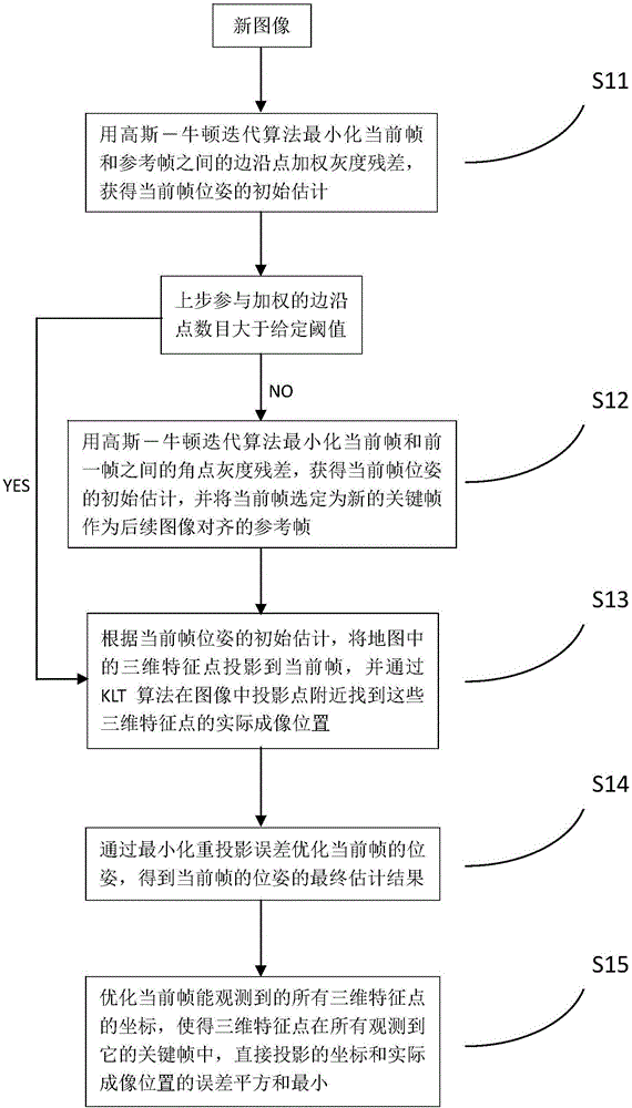
[0025] The overall process of the method for the monocular vision range measurement of unmanned aerial vehicles based on the edge point information in the image proposed by the present invention is as follows: figure 2 As shown, it is characterized in that it includes initialization and parallel processing of motion estimation, map construction and depth map estimation; specifically includes the following steps:

[0026] 1) Initialization: Select two frames from the image sequence captured by the downward-looking monocular camera fixedly connected to the UAV to construct the initial map and initial depth map. In this embodiment, the map uses a set of key frame sets {r m} and a set of three-dimensional feature points {p i}, where r represents the key frame, the subscript m represents the mth key frame, which is a positive integer, p represents the th...


PUM


Abstract

The invention relates to a monocular vision ranging method based on edge point information in an image and belongs to the unmanned aerial vehicle navigation and positioning technical field. The method includes the following steps that: two frames of images are selected from an image sequence captured by a downward-looking monocular camera fixedly connected with an unmanned aerial vehicle so as be adopted to construct an initial map and an initial depth graph, a first frame is adopted as a first key frame in the map, and a camera coordinate system corresponding to the first frame is adopted as a world coordinate system, and initialization is completed; and three threads, namely, a motion estimation thread, a map construction thread and a depth graph estimation thread are carried out parallelly, wherein the motion estimation thread aligns known map and depth graph information with a current frame so as to obtain a ranging result, and optimizes the existing map information according to the ranging result, and the map construction thread and the depth graph estimation thread operate simultaneously so as to maintain the map and depth graph information. According to the method of the invention, the multi-core architecture of a modern processor is fully utilized, and the edge point information in the image can be effectively utilized, and based on corner point information, the efficiency of the algorithm is improved. The method has higher adaptability.

Description

technical field [0001] The invention belongs to the technical field of unmanned aerial vehicle navigation and positioning, and in particular relates to a monocular vision ranging method utilizing edge point information in an image. Background technique [0002] In many application scenarios, people cannot rely on GPS for accurate positioning, such as indoors, between urban buildings, or in jungles, valleys, or even alien planets. It is very intuitive to use vision for navigation: all animals with eyes in nature use vision for some form of navigation. Insects such as flies and bees judge the relative motion between themselves and the target through optical flow. Most of the time, humans Determine where you are based on what you see. [0003] Under the premise of not using GPS, due to cost and weight considerations, most micro drones use a navigation solution combined with an inertial measurement unit and a single camera, and can also be equipped with ultrasonic sensors and a...

Claims


Application Information

Patent Timeline
Patent Type & Authority Applications(China)
IPC IPC(8): G06T7/00G06T7/20G01C21/20
Inventor 程农杨盛李清田振
Owner TSINGHUA UNIV
Why Eureka
Try Eureka