
Periodic resultant steering vector maximum likelihood algorithm based on terrain parameter table

A technique of synthesizing steering vectors and maximum likelihood algorithms, applied in radio wave measurement systems, instruments, etc., can solve the problems of terrain information not being clearly and effectively explained, unable to break through, poor real-time performance, etc., to eliminate multipath effects, eliminate Effect of lobe splitting phenomenon, good accuracy and robustness

Inactive Publication Date: 2016-11-09
SHANGHAI RADIO EQUIP RES INST
View PDF7 Cites 6 Cited by
  • Summary
  • Abstract
  • Description
  • Claims
  • Application Information

AI Technical Summary

Problems solved by technology

[0004] In the prior art, the paper "Frequency Agile Phased Array Radar Target Multipath DOA Estimation Algorithm" recorded in "System Engineering and Electronic Technology" 2006, Volume 27, Issue 11 adopts frequency diversity technology, by changing the operating frequency of the radar However, changing the angle measurement error and relying on multiple smoothing to reduce the angle measurement error, the angle measurement accuracy is still low; the paper "Meter Wave Radar Measurement Based on Lobe Splitting" recorded in "Acta Electronics" 2007, Volume 35, Issue 6 High Method and Its Application" has high requirements on the flatness of the ground, and the measurement accuracy can only reach 1% of the distance, which is difficult to meet the actual use requirements of some high precision; "Journal of Electronics and Information Technology", Vol. The paper "DOA Estimation Method Based on Alternating Projection and Its Application in Meter Wave Radar" recorded in the first issue proposes a DOA estimation method based on alternating projection as a two-dimensional nonlinear optimization problem, with a large amount of calculation and poor real-time performance. And without using prior information such as terrain
[0005] In addition, the ordinary digital beam method adopted in the patent "Digital Beamforming System and Method for Two-dimensional Digital Array Radar" (Application No.: 201010509676.5) cannot break through the limitation of "Rayleigh limit", and eliminate the influence of multipath effect and lobe splitting phenomenon; The algorithm adopted in the patent "Beamforming Meter Wave Radar Altimetry Method Based on Synthetic Steering Vectors" (Application No.: 201310192066.0) has high requirements on the signal-to-noise ratio, and does not make full use of the prior information of the digital array radar; the patent "Based on Terrain matching digital array meter-wave radar super-resolution altimetry method" (application number: 201110120849.9) did not clearly and effectively explain how to obtain and use terrain information

Method used


Image

  • Periodic resultant steering vector maximum likelihood algorithm based on terrain parameter table
  • Periodic resultant steering vector maximum likelihood algorithm based on terrain parameter table
  • Periodic resultant steering vector maximum likelihood algorithm based on terrain parameter table

Examples


Embodiment Construction

[0050] Aiming at the problem of low-elevation angle height measurement of digital array radar, the present invention proposes a periodical synthetic steering vector maximum likelihood algorithm based on terrain parameter table. This algorithm can effectively distinguish the direct wave and multipath reflected wave within a beam width, break through the limitation of the Rayleigh limit of the real aperture of the array, eliminate the influence of multipath effect, and use the periodicity of the synthetic steering vector, based on the quadratic The terrain parameter table is generated from the prior information of the radar, and the error compensation is performed in real time. The engineering realization is less difficult, simple and effective, and has good feasibility.

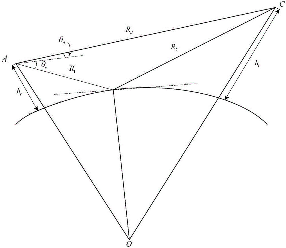
[0051] figure 1 In the shown earth surface model, the target distance, height and other information provided by the secondary radar, according to the earth surface model, inverts the prior information such as ...


PUM


Abstract

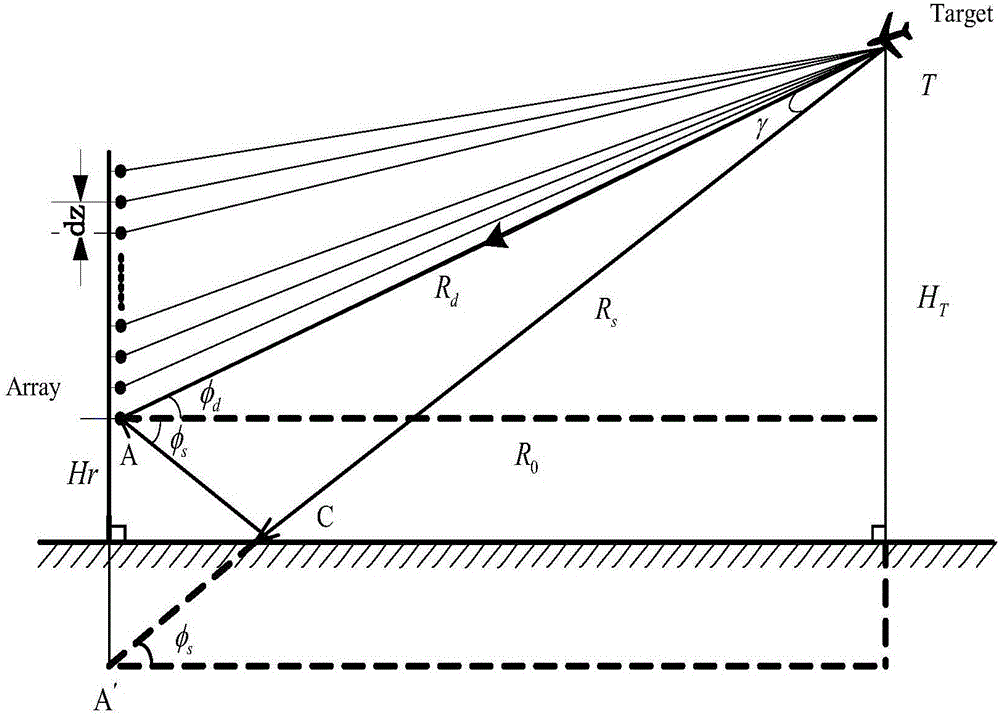
The invention provides a periodic resultant steering vector maximum likelihood algorithm based on a terrain parameter table. The method provided by the invention is applied to digital array radar low elevation angle height measurement. An echo signal of an array is composed of a direct wave and a multi-path reflection wave. The concept of multipath factor is introduced. A resultant steering vector corresponding to the echo signal is established. Then, the resultant steering vector is applied to the maximum likelihood algorithm to form the resultant steering vector maximum likelihood algorithm. The periodicity of the multipath factor of the resultant steering vector is utilized to determine a terrain search scope. Terrain parameters corresponding to all angles in the terrain search scope are established so as to form the terrain parameter table. In the subsequent height measurement of the resultant steering vector maximum likelihood algorithm, the established terrain parameter table is directly used to conduct real-time error compensation. The method provided by the invention is good in precision and robustness.

Description

technical field [0001] The invention belongs to the technical field of radar signal processing, and relates to a periodically synthesized steering vector maximum likelihood algorithm, which is especially suitable for digital array radar low-elevation angle height measurement. Background technique [0002] Spatial spectrum estimation technology is a new spatial domain signal processing technology developed in the past 30 years. It can also be said that it is a new technology developed on the basis of beamforming technology, "null point" forming technology and time domain estimation technology. , its main goal is to study various algorithms to improve the angle estimation accuracy, angle resolution and increase the operation speed of spatial signals (including mutually independent signals, partially correlated signals and coherent signals) within the processing bandwidth. When there are multi-source signals, the extraction and measurement of the required signals have always be...

Claims


Application Information

Patent Timeline
Patent Type & Authority Applications(China)
IPC IPC(8): G01S7/02
CPCG01S7/02
Inventor 吴刚王志诚余渝生蔡信张天键
Owner SHANGHAI RADIO EQUIP RES INST
Learn More