Piggyback mobile surveying and mapping system based on laser radar and panorama camera

A technology of laser radar and panoramic camera, which is applied in the field of geographic information surveying and mapping, can solve the problems of system failure, low efficiency, and the trolley can only be applied to the ground level environment, etc., to achieve strong adaptability, enhanced understanding, and good passability Effect

Inactive Publication Date: 2017-02-22
欧思徕(北京)智能科技有限公司
View PDF3 Cites 37 Cited by
  • Summary
  • Abstract
  • Description
  • Claims
  • Application Information

AI Technical Summary

Problems solved by technology

The system overcomes (1) the failure of the existing ground mobile measurement system in a non-GNSS environment; (2) the inefficiency caused by traditional fixed laser scanning requiring a large number of stations to stitch point clouds; (3) based on two-dimensional The cart of SLAM technology can only be applied to the problem of ground level environment

Method used


Image

  • Piggyback mobile surveying and mapping system based on laser radar and panorama camera
  • Piggyback mobile surveying and mapping system based on laser radar and panorama camera
  • Piggyback mobile surveying and mapping system based on laser radar and panorama camera

Examples


Embodiment Construction

[0040] The specific implementation manners of the present invention will be further described in detail below in conjunction with the accompanying drawings and embodiments.

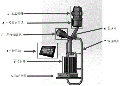
[0041] A backpack mobile surveying and mapping system based on laser radar and panoramic camera. The number of laser radars can be installed with 2 or 3 according to the needs. Now take the installation of 2 as an example.

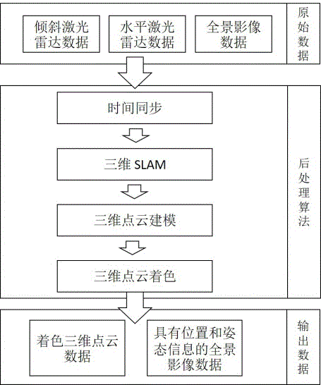
[0042] A backpack mobile surveying and mapping system based on lidar and panoramic camera, mainly including acquisition equipment module and post-processing module.

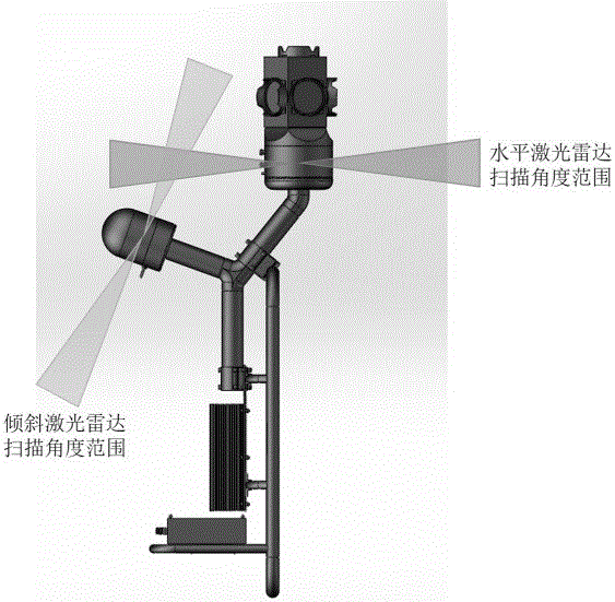
[0043] Such as figure 1 As shown, the acquisition device module is a backpack type, which is composed of a panoramic camera 1, a laser radar 2, a handheld terminal 3, a controller 4, a mobile power supply 5, a support pole 6 and a backpack frame 7. The acquisition equipment module is connected to each component by the backpack frame. The panoramic camera is located at the top of the acquisition equipment module, and the...


PUM


Abstract

The present invention discloses a piggyback mobile surveying and mapping system based on a laser radar and a panorama camera. The system mainly comprises a collection device module and a post-processing module. The collection device module is a piggyback mode and is mainly composed of a panorama camera, a laser radar, a controller, a hand-held terminal, a portable power source, a bracing piece and a piggyback frame, and each part is connected and supported by the piggyback frame. The system and method can continuously move the obtained surrounding scene information, and are good in passing ability, high in adaptability and high in data acquisition efficiency. The problems which the system overcomes comprise: (1) the problem of the failure of a current ground mobile measurement system in the environment without GNSS; (2) the problem of low efficiency because the traditional fixed laser scanning needs lots of station changing joint point cloud; and (3) the problem that a cart based on the two-dimensional SLAM technology is only suitable for the ground horizontal environment.

Description

technical field [0001] The invention relates to the field of geographic information surveying and mapping, in particular to a backpack-type mobile surveying and mapping system composed of a laser radar and a panoramic camera. Background technique [0002] With the development of computer technology and digital map technology, the accuracy of information collection and reconstruction of 3D scenes is getting higher and higher, and its application is becoming more and more extensive. Both machine and military fields have important applications and economic benefits. [0003] The 3D point cloud data acquisition of ground scenes is generally divided into two types, mobile laser scanning and fixed laser scanning. At present, the existing ground mobile measurement systems are usually vehicle-based mobile measurement systems, such as a ground mobile measurement device with Chinese patent number 2014202128221 and a vehicle-mounted measurement integrated system based on laser scannin...

Claims


Application Information

Patent Timeline
Patent Type & Authority Applications(China)
IPC IPC(8): G01S17/02G01S17/89G01C11/00G01C21/00
CPCG01C11/00G01C21/005G01S17/86G01S17/89
Inventor 佟国峰姜斌梁东艺李勇
Owner 欧思徕(北京)智能科技有限公司
Why Eureka
Try Eureka