Multi-dimensional geographic scene identification method fusing geographic region knowledge

A technology for geographical area and scene recognition, applied in the field of multi-dimensional geographical scene recognition, can solve the problems of small data sample size, high cost of manual labeling and low classification accuracy, and achieve the effect of improving efficiency

Active Publication Date: 2017-03-29
CHONGQING UNIV OF POSTS & TELECOMM
View PDF3 Cites 35 Cited by
  • Summary
  • Abstract
  • Description
  • Claims
  • Application Information

AI Technical Summary

Problems solved by technology

[0007] When CNN extracts deep-level features of images, it builds a multi-layer network structure, which requires a large number of labeled data samples to train network parameters. However, the cost of manual lab

Method used


Image

  • Multi-dimensional geographic scene identification method fusing geographic region knowledge
  • Multi-dimensional geographic scene identification method fusing geographic region knowledge
  • Multi-dimensional geographic scene identification method fusing geographic region knowledge

Examples


Embodiment Construction

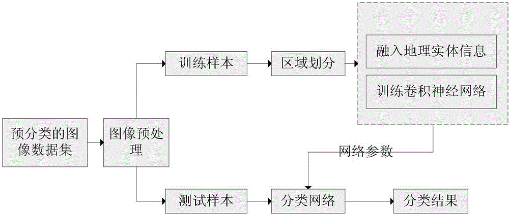
[0043] The technical solutions in the embodiments of the present invention will be described clearly and in detail below with reference to the drawings in the embodiments of the present invention. The described embodiments are only some of the embodiments of the invention.

[0044] Technical scheme of the present invention is as follows:

[0045] The article image classification method based on the convolutional neural network model provided by the present invention will be described in detail below with reference to the drawings and specific embodiments.

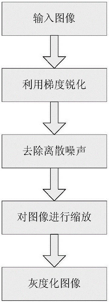
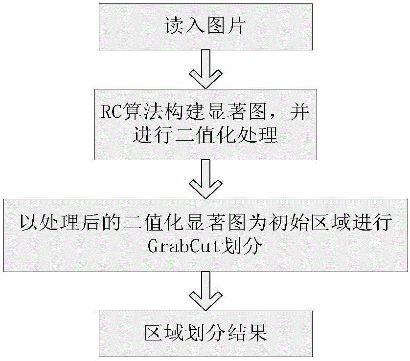
[0046] Preprocess the images in the database to obtain the grayscale image of the geographic scene with a preset size, refer to figure 2 ,Specific steps are as follows:

[0047] (1) Use gradient sharpening to make the image more prominent for analysis. The absolute value of the difference between the pixel value of the current point and the next pixel value, plus the absolute value of the difference between the pixel valu...


PUM


Abstract

The invention discloses a multi-dimensional geographic scene identification method fusing geographic region knowledge. The method comprises the steps of preprocessing images in a database to obtain satisfied geographic scene images; obtaining object region image blocks by utilizing a method for quickly searching for object regions in the images; pre-training the obtained object region image blocks of the geographic images by using a deep convolutional neural network, performing an accurate adjustment process until the performance of the deep convolutional neural network of the scene images is no longer improved, and fusing feature matrixes into output eigenvectors; pre-establishing a geographic entity noun keyword dictionary by acquired entity noun data in geographic scene classification, performing word segmentation on target identification result data to obtain key words in a target identification result, and establishing text features; and fusing the text features and multi-dimensional image features into eigenvectors as inputs, realizing cross-media-data identification classification, and realizing scene classification fusing geographic entity information.

Description

technical field [0001] The invention relates to the technical field of image processing, in particular to multi-dimensional geographic scene recognition technology. Background technique [0002] Scene classification, that is, to complete the automatic recognition of image scene categories (such as mountains, forests, bedrooms, living rooms, etc.) based on the features contained in the scene image, is an important branch in the field of image understanding, and has become an important branch of multimedia information management, computer vision, etc. The hot issue in fields such as, is subjected to the extensive attention of researcher. Scene classification is of great significance to the development of multimedia information retrieval and other fields, and has broad application prospects and theoretical significance in many fields. [0003] With the advent of the big data era, deep convolutional neural networks with more hidden layers have more complex network structures, a...

Claims


Application Information

Patent Timeline
IPC IPC(8): G06F17/30
CPCG06F16/29
Inventor 丰江帆刘媛媛徐欣夏英
Owner CHONGQING UNIV OF POSTS & TELECOMM
Why Eureka
Try Eureka