Integrated management system of land and resources

A technology for comprehensive management and land resources, applied in resources, data processing applications, calculations, etc., can solve the problems of lack of quantitative positioning analysis of land information, data update lag, and heavy query and statistical workload, so as to improve the guarantee service ability, accurate The effect of updating data

Inactive Publication Date: 2017-05-03
星际空间(天津)科技发展有限公司
View PDF1 Cites 22 Cited by
  • Summary
  • Abstract
  • Description
  • Claims
  • Application Information

AI Technical Summary

Problems solved by technology

The data has not been systematically sorted out, the data update lags behind, the query and statistics workload is heavy and the efficiency is low, the lack of quantitative positioning and analysis of land information in each link, the technical means are relatively backward, and the rapid response ability to deal with important emergencies is insufficient, etc.
[0007] At present, there is no technical solution that can effectively combine and apply business data information and geographic information involved in the actual application of land and resources through software architecture, cloud data processing, formula calculation and application methods, so as to achieve data Intelligent information transmission integrating processing, analysis, application and display, so as to realize the effective integration of business information and two-dimensional and three-dimensional graphic information, realize multi-dimensional three-dimensional information presentation, and display data information in text and graphics Form an analysis report in the form of a report to assist decision makers in making proposals

Method used


Image

  • Integrated management system of land and resources
  • Integrated management system of land and resources
  • Integrated management system of land and resources

Examples


Embodiment 1

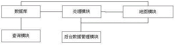
[0059] figure 1 The schematic diagram of the structure of the integrated land and resources management system provided for this embodiment, such as figure 1 As shown, a land and resources comprehensive management system, the system includes a query module, a processing module, a database, a background data management module and a map module, wherein: the database handles business information in tabular form, and map information in a layer form Combined with the land business requirements, the business attribute information and land parcel information in the processing module are stored in the associated business information table and layer table, and the stored information is transmitted to the query module, and the query module will receive the The information is queried according to the actual business needs, and displayed in the form of text, tables, and graphics; the background data management module synchronizes the information between the business information and the map...

Embodiment 2

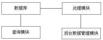
[0108] figure 2 The schematic diagram of the structure of the integrated land and resources management system provided for this embodiment, such as figure 2 As shown, a land and resources comprehensive management system, the system includes a query module, a processing module, a database and a background data management module, wherein: the database performs tabular processing of business information, and performs layer tabular processing of map information, Combined with the needs of land business, the business attribute information and land parcel information in the processing module are stored in the associated business information table and layer table, and the stored information is transmitted to the query module. The query module will receive the information according to the actual situation. Relevant inquiries are made for business needs and displayed in the form of text, tables, and graphics; the background data management module synchronizes the information between ...


PUM


Abstract

The invention discloses an integrated management system of land and resources, and belongs to the field of geographic information. The system is characterized by comprising a query module, a processing module, a database, a background data management module and a map module; the database processes service information and map information into tables, information processed by the processing module is stored, and the query module inquires and displays the received information according to practical service requirements; and the background data management module integrates the processed data information in the processing module with location and service attribute information in the map module to inquire and analyze land and resource information. The integrated management system has the advantages that data processing, analysis, application and display integrated intelligent information transfer is realized, the service information is fused with 2D and 3D graph information effectively, multi-dimensional stereoscopic information display is realized, data information forms analysis reports in the forms of characters, graphs and reports, and a decision maker is helped in proposal decisions.

Description

technical field [0001] The present invention relates to the technical field of geographic information, specifically, an effective combination and application of business data information and geographic information involved in the actual application of land resources through software architecture, cloud data processing, formula calculation and application methods, To achieve a comprehensive management system of land and resources that can integrate data processing, analysis, application and display into an intelligent information transmission. Background technique [0002] There are two understandings of smart city, narrow sense and broad sense. In a narrow sense, a smart city refers to a city based on the Internet of Things, through the interconnection of things, interconnection, and intelligence, so that various functions in the city can be coordinated with each other, with a high degree of integration of smart technology, high-end development of smart industries, and effic...

Claims


Application Information

Patent Timeline
Patent Type & Authority Applications(China)
IPC IPC(8): G06Q10/06
Inventor 王力孙兆海王贺朋苏俊杨文博毛继国
Owner 星际空间(天津)科技发展有限公司
Why Eureka
Try Eureka