GNSS (Global Navigation Satellite System) three-dimensional displacement monitoring and correcting system and remote data processing method thereof

A technology of displacement monitoring and correction system, which is applied in the direction of radio wave measurement system, satellite radio beacon positioning system, signal transmission system, etc. It can solve problems such as complex implementation, wrong monitoring results, and affecting calculation results, so as to eliminate displacement Distortion, correct monitoring results, and guaranteed solution accuracy

Pending Publication Date: 2017-05-10
SANHE WENKONG COMP TECH CO LTD
View PDF5 Cites 7 Cited by
  • Summary
  • Abstract
  • Description
  • Claims
  • Application Information

AI Technical Summary

Problems solved by technology

The pull wire or laser surface displacement monitor belongs to the relative displacement monitoring method, which measures the distance change between two points in real time. It has the advantages of high precision, no weather influence, and low power consumption, but it can only measure the displacement change in one-dimensional direction; The field reflection method is also one-dimensional measurement, which can measure the deformation of any point along the line. This method is too complicated to implement technically, and the technical level is not very mature, so there should be few; GNSS (Global Navigation Satellite System, Global Navigation Satellite System) based on satellite positioning Navigation satellite system) is a new technology developed rapidly in recent years, and it has been applied more and more in the fields of geology and engineering
[0004] However, the surface deformation of geological disasters is a complex process, usually accompanied by the oblique deformation of the surface, which leads to large errors in the current GNSS three-dimensional displacement monitoring system, resulting in a large distortion of the measured displacement, which affects the calculation results, and even leads to Monitoring results are wrong

Method used


Image

  • GNSS (Global Navigation Satellite System) three-dimensional displacement monitoring and correcting system and remote data processing method thereof
  • GNSS (Global Navigation Satellite System) three-dimensional displacement monitoring and correcting system and remote data processing method thereof
  • GNSS (Global Navigation Satellite System) three-dimensional displacement monitoring and correcting system and remote data processing method thereof

Examples


Embodiment Construction

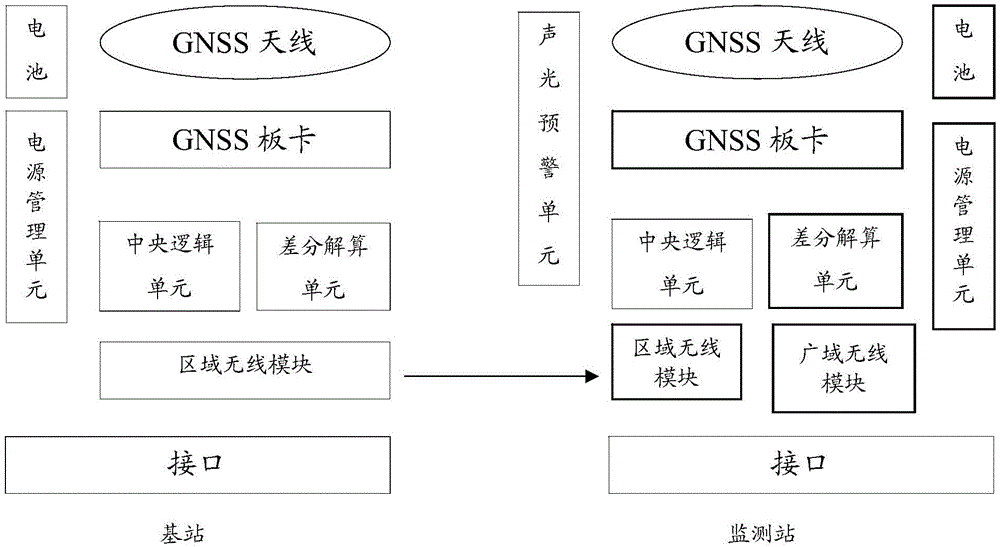
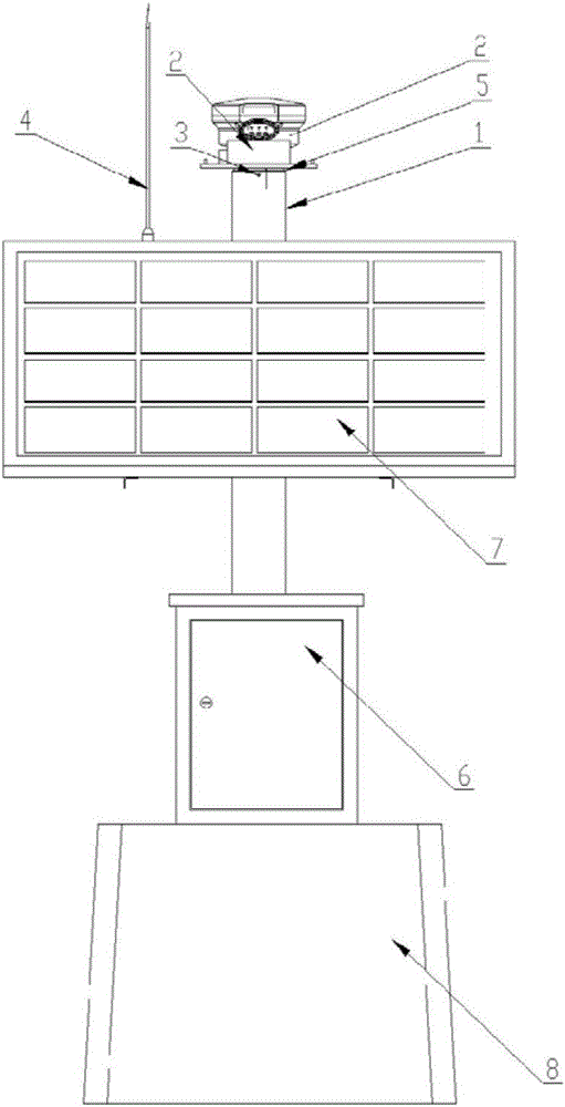
[0017] Such as figure 1 , 2 , 4, this GNSS three-dimensional displacement monitoring and correction system includes a monitoring station equipment part and a base station equipment part;

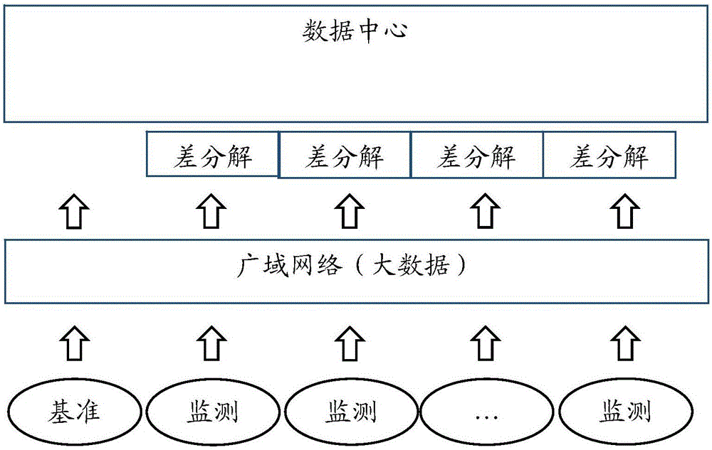
[0018] The monitoring station equipment part includes: monitoring station GNSS antenna, monitoring station GNSS board, monitoring station central logic unit, monitoring station area wireless module, monitoring station wide area wireless module, monitoring station differential calculation unit, monitoring station power management module, monitoring station The station battery; the GNSS antenna of the monitoring station receives real-time satellite signals, and the GNSS board card of the monitoring station parses the satellite signal into ephemeris data; the central logic unit of the monitoring station receives the original ephemeris data from the GNSS board card of the monitoring station; the central logic unit of the monitoring station reads Get the correction number data sent by the base s...


PUM


Abstract

The invention discloses a GNSS (Global Navigation Satellite System) three-dimensional displacement monitoring and correcting system with small errors, eliminating the distortion of displacement amount, ensuring the solution precision and the accurate monitoring result. The system comprises a monitoring station device part and a base station device part wherein the monitoring station device part comprises a monitoring station GNSS antenna, a monitoring station GNSS board clamp, a monitoring station central logic unit, a monitoring station region wireless module, a monitoring station wide area wireless module, a monitoring station differential solution unit, a monitoring station power supply management module, and a monitoring station battery. The monitoring station device part is mounted at the top end of a standing column, and the inner part of the central logic unit is integrated with a double-shaft inclined sensor. The double-shaft inclined sensor is configured to measure the inclined angle and correct the three-dimensional coordinates. Through the inclined angle, the height of the standing column and the actually measured displacement amount, the distortion of displacement amount generated at the top end of the standing column is eliminated. The invention also provides a remote data processing method.

Description

technical field [0001] The invention belongs to the technical field of safety monitoring, and in particular relates to a GNSS three-dimensional displacement monitoring and correction system and a remote data processing method. Background technique [0002] In the field of disaster prevention and mitigation of engineering and geological disasters, the monitoring of surface displacement changes of potential disaster bodies is very important. How to obtain real-time displacement information of the measured points and how to achieve rapid and effective early warning are major problems to be solved urgently. . [0003] At present, the equipment used for automatic surface displacement monitoring mainly includes: cable type surface displacement monitor, laser type surface displacement monitor, time domain reflectometry, GPS monitoring system, etc. The pull wire or laser surface displacement monitor belongs to the relative displacement monitoring method, which measures the distance...

Claims


Application Information

Patent Timeline
Patent Type & Authority Applications(China)
IPC IPC(8): G01S19/14G01S19/33G08C17/02H04W84/18
CPCH04W84/18G08C17/02G01S19/14G01S19/33
Inventor 许利凯魏世玉杨建国赵静李吉庆柳莹刘亚明许永盼
Owner SANHE WENKONG COMP TECH CO LTD
Why Eureka
Try Eureka