Hydraulic and hydroelectric engineering geologic three-dimensional real scene field logging and mapping system

A technology of hydraulic engineering and geology, applied in image data processing, electrical digital data processing, geographic information database, etc., can solve problems such as the inability to realize rapid data analysis

Active Publication Date: 2017-06-13
POWERCHINA CHENGDU ENG +1
View PDF8 Cites 22 Cited by
  • Summary
  • Abstract
  • Description
  • Claims
  • Application Information

AI Technical Summary

Problems solved by technology

[0016] The technical problem to be solved by the present invention is: to propose a hydropower hydraulic engineering geology three-dime...

Method used


Image

  • Hydraulic and hydroelectric engineering geologic three-dimensional real scene field logging and mapping system
  • Hydraulic and hydroelectric engineering geologic three-dimensional real scene field logging and mapping system

Examples


Embodiment Construction

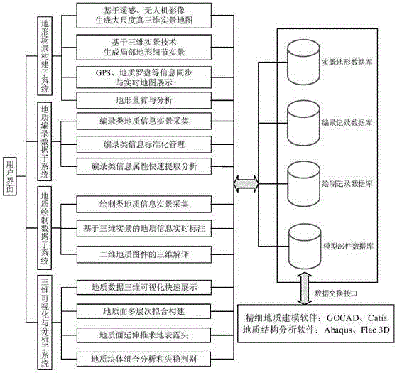
[0035] The invention provides a hydropower and water conservancy engineering geological three-dimensional real-scene field cataloging and mapping system, which is an engineering geological field auxiliary system for marking, drawing, processing and analyzing in a digital three-dimensional scene according to the geological catalog information obtained by field geological survey.

[0036] Below in conjunction with accompanying drawing and embodiment the scheme of the present invention will be further described:

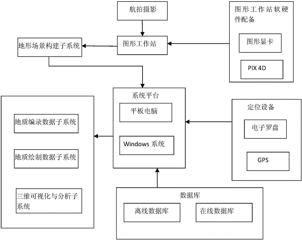
[0037] refer to figure 1 and figure 2 , the hydropower hydraulic engineering geology 3D real scene field cataloging and mapping system in the present invention includes a hardware system and a software system, wherein the hardware system includes aerial photography image acquisition equipment, graphics workstations, computer terminals and portable land photography image acquisition equipment, and the software system includes terrain Scene construction subsystem, geolo...


PUM


Abstract

The invention relates to a system for conducting computer geological modeling, simulation and analysis according to hydraulic and hydroelectric engineering geologic field exploration data, and discloses a hydraulic and hydroelectric engineering geologic three-dimensional real scene field logging and mapping system. The problem that in a traditional technology, quick data analysis cannot be achieved is solved. The hydraulic and hydroelectric engineering geologic three-dimensional real scene field logging and mapping system comprises a hardware system and a software system, wherein the hardware system comprises an aerial photographic image collecting device, a graph work station, a computer terminal and a portable land photographic image collecting device; the software system comprises a terrain scene building subsystem, a geological logging data subsystem, a geological plotting data subsystem, a three-dimensional visualization and analysis subsystem and an engineering geologic data management and exchange subsystem. According to engineering geologic filed logging requirements, the quick analysis and modeling functions are provided, and a digitized, intelligentized and three-dimensional visualized solution is provided for engineering geologic field logging operation.

Description

technical field [0001] The invention relates to a system for computer geological modeling, simulation and analysis based on hydropower and water conservancy engineering geological field survey data, in particular to a hydropower and water conservancy engineering geology three-dimensional real-scene field cataloging and mapping system. Background technique [0002] Geological survey of hydropower and water conservancy projects is an important work content of hydropower and water conservancy projects in the feasibility study stage, design stage and construction stage, and is an important basis and guarantee for project design, construction and operation. However, due to the limited site conditions, the means of engineering geological survey are relatively single, and the survey process is not convenient. The accuracy and applicability of the cataloged results depend on the experience and technical level of the geologists themselves. Many advanced technical experiences inside an...

Claims


Application Information

Patent Timeline
IPC IPC(8): G06T17/05G06F17/30
CPCG06T17/05G06T2200/08G06F16/29
Inventor 张世殊李明超王刚王孜越石伟明张野田华兵韩帅刘仕勇
Owner POWERCHINA CHENGDU ENG
Why Eureka
Try Eureka