Parallel computing-based domestic remote-sensing satellite fast registration method

A remote sensing satellite and parallel computing technology, applied in the field of satellite image processing, can solve the problems of slow registration speed, non-signature processing and providing public services, and few domestic satellite remote sensing data processing methods, etc., to achieve the effect of improving registration accuracy.

Inactive Publication Date: 2017-08-08
梅非
View PDF0 Cites 4 Cited by
  • Summary
  • Abstract
  • Description
  • Claims
  • Application Information

AI Technical Summary

Problems solved by technology

In the field of remote sensing applications, image registration is a necessary process to realize image fusion, change detection, and image correction; Image registration generally includes two steps. The first step is to select a sufficient number of registration control points (GCPS). These control points require a sufficient number and a relatively uniform distribution. The second step is to combine the two One of the two images is used as a reference image, and the other is used as a registration image. After the registration image is transformed, it is registered with the reference image for comparison and analysis. The first step is extremely fine, due to the actual processing of satellite remote sensing The image width is very large, and the operator has to select a large number of control points between the two images, and the selection must be quite precise. If manual calibration is performed with the help of professional image processing software, it will not only waste time and manpower, but also be affected by human subjective factors. Therefore, the rapid and accurate registration of large-format remote sensing images has attracted the attention and research of scholars in recent years.
[0003] In order to overcome this shortcoming, scholars have proposed automatic registration methods, which are mainly divided into three categories based on grayscale, transform domain and feature. However, in practical applications, there are generally the following shortcomings: insufficient number of control points, control Uneven distribution of certain data, greatly affected by clouds, fog, uneven illumination, etc., registration speed is too slow, does not meet the requirements of processing the data on the same day and providing public services on the same day, and there are few processing methods for domestic satellite remote sensing data, such as CMB There are problems with rotation, translation, zooming, etc. in each band of the Earth resources satellite series

Method used


Image

  • Parallel computing-based domestic remote-sensing satellite fast registration method
  • Parallel computing-based domestic remote-sensing satellite fast registration method
  • Parallel computing-based domestic remote-sensing satellite fast registration method

Examples


Embodiment

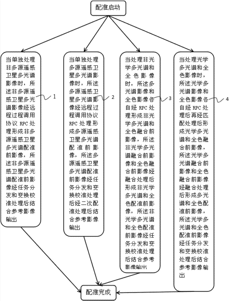
[0039] This embodiment includes: figure 1 As shown, the rapid registration method of domestic remote sensing satellites based on parallel computing, the registration method includes, when processing non-multi-source remote sensing satellite multi-spectral images separately, the non-multi-source remote sensing satellite multi-spectral images are processed via the remote procedure call protocol RPC processing forms non-multi-source remote sensing satellite multi-spectral registration pre-image, and the non-multi-source remote sensing satellite multi-spectral pre-registration image is combined with reference image output 1 after task distribution and transformation calibration processing;

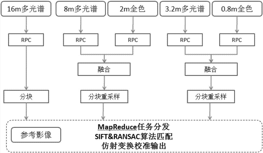
[0040] The environmental series has a 30m multi-spectrum in the visible light image, and the registration process can refer to the 16m processing flow of Gaofen No. 1.

[0041] Such as figure 2 As shown, the Gaofen series includes the 16m multispectral image of Gaofen 1. Its RPC parameters c...


PUM


Abstract

The invention belongs to the technical field of satellite image processing, and in particular relates to a method for rapid registration of domestic remote sensing satellites based on parallel computing, including methods such as multiple images. The impact of uneven illumination is great, the registration speed is too slow, and it does not meet the requirements of processing the data on the same day and providing public services on the same day. There are few processing methods for domestic satellite remote sensing data. For example, there are rotations, Problems such as panning and zooming can quickly complete the processing of satellite images of various scenes in a streamlined and fully automated manner, unify the coordinates of multi-source satellite images and publish maps online for browsing, and the deformation of ground objects caused by different time phases and different inclination angles 1. The multi-source remote sensing satellite image registration has high precision, fully utilizes hardware resources, and improves the processing efficiency of large-scale parallel registration of massive remote sensing images.

Description

technical field [0001] The invention belongs to the technical field of satellite image processing, in particular to a fast registration method for domestic remote sensing satellites based on parallel computing. Background technique [0002] With the development of the Internet and mobile Internet, the application of remote sensing satellites has been integrated into the lives of the public, and the application of remote sensing space information is also developing along the direction of continuous innovation. Facing the urgent needs and rapid development of public remote sensing, it is necessary to make full use of multi-source satellite remote sensing data collection capabilities and fully automated remote sensing processing technology to launch remote sensing services for the public and realize the public value of remote sensing. The unique geospatial attributes of remote sensing images make Its application range is very wide. Remote sensing images with different resoluti...

Claims


Application Information

Patent Timeline
Patent Type & Authority Applications(China)
IPC IPC(8): G06T7/33
CPCG06T2207/10032G06T2207/10036G06T2207/10041
Inventor 梅非
Owner 梅非
Why Eureka
Try Eureka