Hyper-spectral remote sensing image fusion method based on multi-scale geometric analysis and PCA transform
A hyperspectral remote sensing and hyperspectral image technology, applied in image enhancement, image analysis, image data processing, etc., can solve the problems of band selection, low computing efficiency, too many dimensions, etc., and achieve good quality and facilitate extraction Effect
- Summary
- Abstract
- Description
- Claims
- Application Information
AI Technical Summary
Problems solved by technology
Method used
Image


Examples
Embodiment Construction
[0038] In order to make the present invention more comprehensible, it will be described in detail below in conjunction with specific embodiments and accompanying drawings. It should be understood that these examples are only illustrative of the invention.
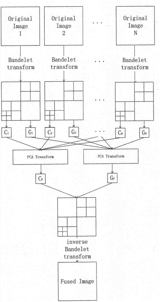
[0039] combine figure 1 A hyperspectral remote sensing image fusion method based on multi-scale geometric analysis and PCA transformation provided by the present invention comprises the following steps:
[0040] Step 1: Hyperspectral image preprocessing and registration of N bands;
[0041] The hyperspectral image not only records the image information of the ground object, but also records the spectral information; each band of the hyperspectral image is imaged separately, and the imaging of these bands can be superimposed, as if after classification, each layer is imaged separately , each layer of surface features has the same radiation value, that is, spectral information.
[0042] Step 2: Carry out multi-scale geomet...
PUM
 Abstract
Description
Claims
Application Information