Earthwork measurement and calculation method with combination of oblique photography, RTK and BIM technologies

A technology of oblique photography and calculation method, which is applied in the field of survey and construction, can solve the problems of inability to re-test and verify the data of measurement points, low efficiency, and large error in the amount of earth and stone, so as to avoid the interference of artificial factors, the result data is accurate, and the efficiency is improved. Effect

Inactive Publication Date: 2017-12-01
SUNYOUNG CONSTR GROUP
View PDF6 Cites 31 Cited by
  • Summary
  • Abstract
  • Description
  • Claims
  • Application Information

AI Technical Summary

Problems solved by technology

Since the construction site area is often large, surveyors can only select a certain working distance for measurement, and the efficiency of data collection is low. The points are non-permanent marks, which are often subject to human disturbance or earthwork settlement, so the measurement point data cannot be retested and verified

Method used


Image

  • Earthwork measurement and calculation method with combination of oblique photography, RTK and BIM technologies
  • Earthwork measurement and calculation method with combination of oblique photography, RTK and BIM technologies

Examples


Embodiment Construction

[0023] The present invention will be further described below in conjunction with the accompanying drawings and embodiments. Of course, the following embodiments should not be understood to limit the present invention.

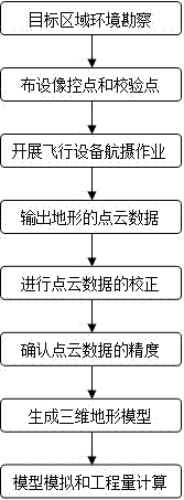
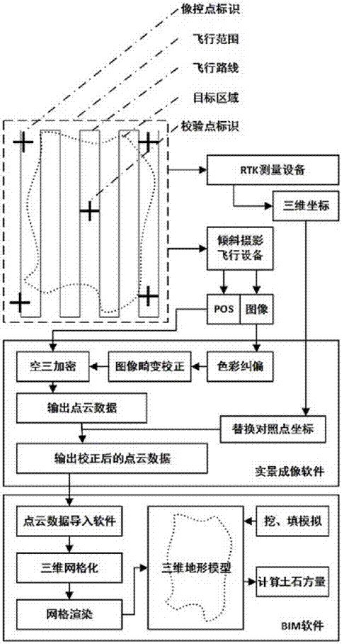
[0024] Such as figure 1 with figure 2 As shown, the embodiment of the present invention provides an earthwork measurement and calculation method combining oblique photography, RTK and BIM technology, and the method includes the following steps:

[0025] S1 Environmental survey of the target area, the environment of the target area should be surveyed before the measurement implementation plan is made, including the vegetation condition and climatic conditions of the target area. Only when the weather conditions are good in all aspects and the surface cleaning is completed, the conditions for field surveying are available;

[0026] S2 Set up image control points around the target area. First, use at least two coordinate points provided by the target area survey instit...


PUM


Abstract

The invention provides an earthwork measurement and calculation method with combination of oblique photography, RTK and BIM technologies. The method includes the steps of: S1) environment exploration of a target zone; S2) arrangement of photo control points and check points surrounding the target zone; S3) aerial photography above the target zone with an air vehicle; S4) import of an oblique photography image from the air vehicle into a real scene imaging software, and image processing to output point cloud data of the terrain; S5) correction to the point cloud data; S6) precision determination of the point cloud data; S7) generation of a three-dimensional terrain model; S8) digging / filling simulation to the three-dimensional terrain model and calculation of earthwork project quantity. By means of the earthwork measurement and calculation method with combination of oblique photography, RTK and BIM technologies, a complete route from data collection to model establishment to project quantity calculation is formed. The method can increase the efficiency of measuring and calculating earthwork, wherein acquired original data has higher precision and data in the calculated result is more accurate.

Description

Technical field [0001] The invention relates to the field of surveying and building construction, in particular to an earthwork measurement and calculation method that combines tilt photography, RTK (Real-TimeKinematic, carrier phase difference technology) and BIM technology. Background technique [0002] Earth and rock balance work refers to the calculation of the amount of earth and rock that needs to be excavated above the design elevation and the amount of earth and rock that needs to be backfilled below the design elevation, compared with the original site, and then the amount of earth and rock that is planned to be transported into or out of the site can be calculated. In the process of foundation excavation, it is necessary to minimize the work of transporting earth and stone into or out of the site. [0003] The most important content of earthwork balance work is to collect the actual elevation of the original site as an important raw data for earthwork calculation. The acc...

Claims


Application Information

Patent Timeline
Patent Type & Authority Applications(China)
IPC IPC(8): G01C11/00
CPCG01C11/00
Inventor 王红磊金戈李飞李迥余昶蒋成杰邱荣昌杨坤林勇王爱武陈路凯成亚
Owner SUNYOUNG CONSTR GROUP
Why Eureka
Try Eureka