Unmanned aerial vehicle visual fast 3D reconstruction method based on equidistant front-view photogrammetry constraints

A 3D reconstruction and photogrammetry technology, applied in the field of 3D reconstruction based on UAV vision, can solve the problem of not making full use of UAV flight planning in field scenes, and achieve the effects of reducing selection time, improving efficiency, and reducing computing time

Inactive Publication Date: 2018-02-02
无际智控(天津)智能科技有限公司
View PDF4 Cites 5 Cited by
  • Summary
  • Abstract
  • Description
  • Claims
  • Application Information

AI Technical Summary

Problems solved by technology

[0004] The purpose of the present invention is to solve the problem that the existing 3D reconstruction technology of outdoor scenes does not make full use of the rough DEM information of the field scene and the flight planning of the UAV, and proposes a fast 3D reconstruction method based on isometric orthographic photogrammetry constraints. First use the DEM information of the field scene to plan the acquisition method of the UAV video, and then use the planning information and flight records to perform fast and accurate 3D reconstruction

Method used


Image

  • Unmanned aerial vehicle visual fast 3D reconstruction method based on equidistant front-view photogrammetry constraints
  • Unmanned aerial vehicle visual fast 3D reconstruction method based on equidistant front-view photogrammetry constraints
  • Unmanned aerial vehicle visual fast 3D reconstruction method based on equidistant front-view photogrammetry constraints

Examples


Embodiment

[0029] The preferred embodiments of the present invention will be described in detail below in conjunction with the accompanying drawings, so that the advantages and features of the present invention can be more easily understood by those skilled in the art, so as to define the protection scope of the present invention more clearly.

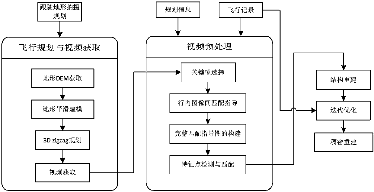
[0030] Examples of the present invention according to figure 1 Steps shown, planning flight capture followed by reconstruction.

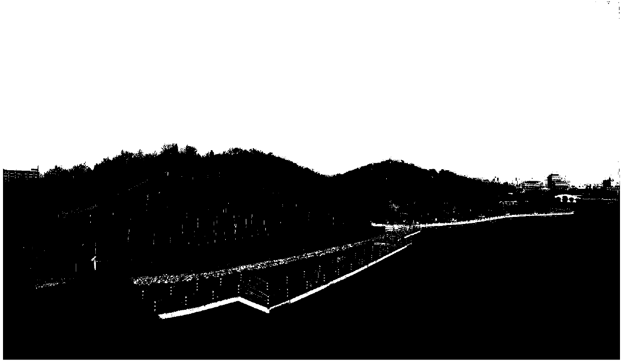
[0031] Step 1. Select a typical environment with undulating terrain, such as figure 2 As shown, first obtain the DEM information of the selected area. In this example, a total station is used for measurement and acquisition. For larger terrains, the DEM information can be purchased directly.

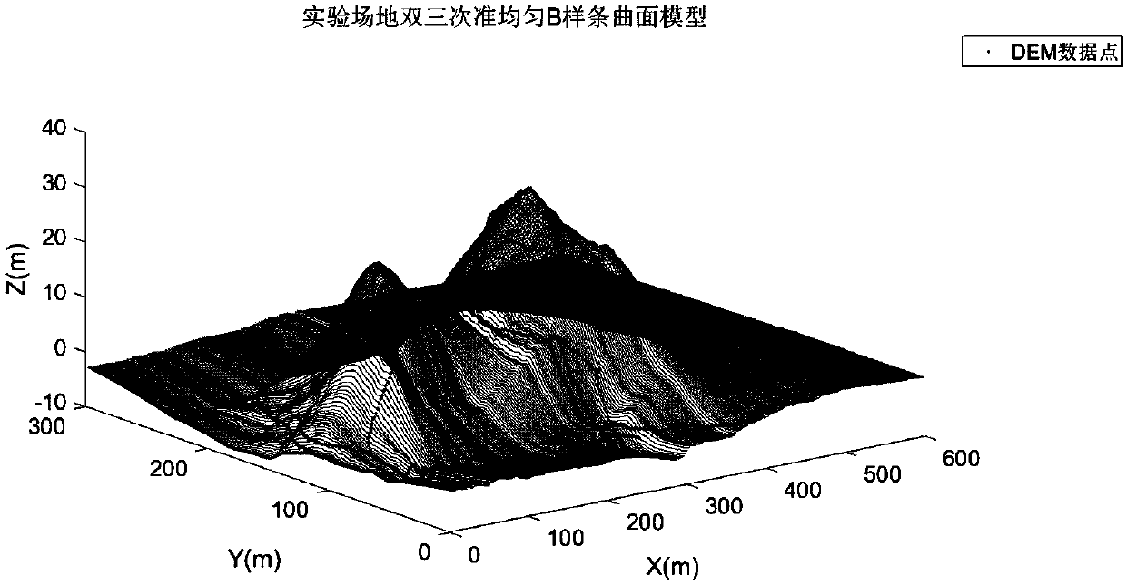
[0032] Step 2. Perform smooth modeling processing on the DEM information, perform interpolation and surface fitting in sequence, and obtain a rough terrain model that can be used for smooth planning, such as image 3 .

[003...


PUM


Abstract

An unmanned aerial vehicle (UAV) visual fast 3D reconstruction method based on equidistant front-view photogrammetry constraints includes the following steps: carrying out terrain modeling and shooting mode planning according to rough DEM information of terrain, adding equidistant front-view photographing constraints, and carrying out fast and accurate 3D reconstruction with a constrained video sequence and planning information; selecting key frames through a fast key frame selection method, including coarse positioning and accurate verification of the key frames; carrying out matching througha planned matching method, so as to greatly reduce invalid matching operation and improve the overall accuracy of reconstruction; and finally, carrying out three-dimensional expression of a scene through sparse point cloud reconstruction, point cloud growth and surface reconstruction in sequence. The method has the characteristics of low cost, accurate scene information obtained, greatly enhancedefficiency of reconstruction, more detailed reconstruction, and the like, is suitable for fast and accurate 3D expression of terrains in a field natural environment, and strongly promotes the application of low-altitude photogrammetry and computer vision in an outdoor environment.

Description

technical field [0001] The invention relates to the fields of photogrammetry and three-dimensional reconstruction, in particular to three-dimensional reconstruction based on unmanned aerial vehicle vision under photography constraints. Background technique [0002] At present, in outdoor or field applications of robots, it is important to dynamically cover a scene, and the goal is to achieve a comprehensive, dynamically updated point cloud plus texture model. It can be applied to forestry in the wild, protection of rare animal and plant resources; it is valuable for border security, forest fire prevention, oil field or offshore platform oil and gas facilities, and power facility monitoring. [0003] Satellites, drones, etc. are commonly used for field coverage. For satellites, there is a problem of insufficient resolution. For aerial images, the current shooting method is often vertically downward or at a fixed angle, so there is a certain loss in the coverage of mountains....

Claims


Application Information

Patent Timeline
Patent Type & Authority Applications(China)
IPC IPC(8): G06T17/05
CPCG06T17/05
Inventor 王鸿鹏张成刘景泰
Owner 无际智控(天津)智能科技有限公司
Why Eureka
Try Eureka