Double-Doppler radar three-dimensional wind field retrieval method

A Doppler radar and wind field inversion technology, applied in the field of dual-Doppler radar three-dimensional wind field inversion, can solve problems such as non-parallel surfaces, no consideration of atmospheric refraction, radial velocity effects, etc., to improve accuracy Effect

Active Publication Date: 2018-03-27
厦门市气象灾害防御技术中心(海峡气象开放实验室 +3
View PDF4 Cites 11 Cited by
  • Summary
  • Abstract
  • Description
  • Claims
  • Application Information

AI Technical Summary

Problems solved by technology

This method mainly has the following disadvantages: 1) Since the earth is approximately spherical and the ground is approximately spherical, the X-O-Y plane is not parallel to the earth’s surface in the Cartesian coordinate system adopted by the existing inversion technology, and the distance between the target point and the origin O Far, the higher the X-O-Y plane is from the ground
However, since the atmosphere is actually a heterogeneous fluid, the electromagnetic wave emitted by the radar is refracted in the atmosphere, and the propagation path of the electromagnetic wave is not a straight line,

Method used


Image

  • Double-Doppler radar three-dimensional wind field retrieval method
  • Double-Doppler radar three-dimensional wind field retrieval method
  • Double-Doppler radar three-dimensional wind field retrieval method

Examples


Embodiment Construction

[0054] In order to make the purpose, technical solution and advantages of the present invention clearer, the technical solution of the present invention will be described in detail below. Apparently, the described embodiments are only some of the embodiments of the present invention, but not all of them. Based on the embodiments of the present invention, all other implementations obtained by persons of ordinary skill in the art without making creative efforts fall within the protection scope of the present invention.

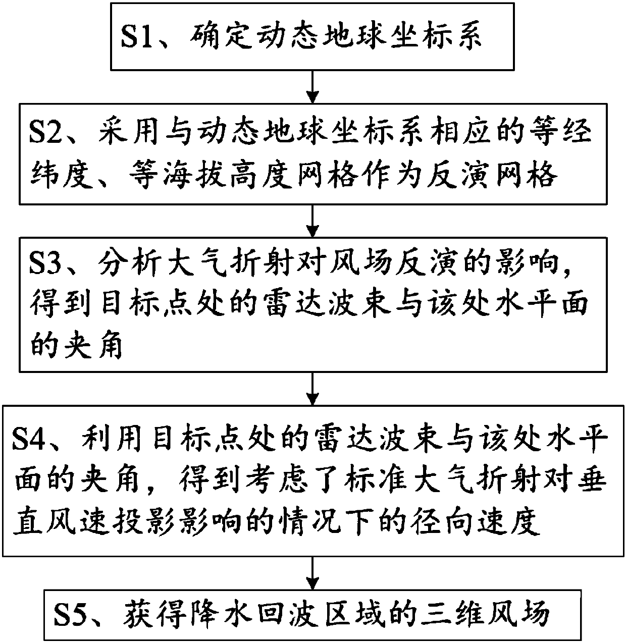
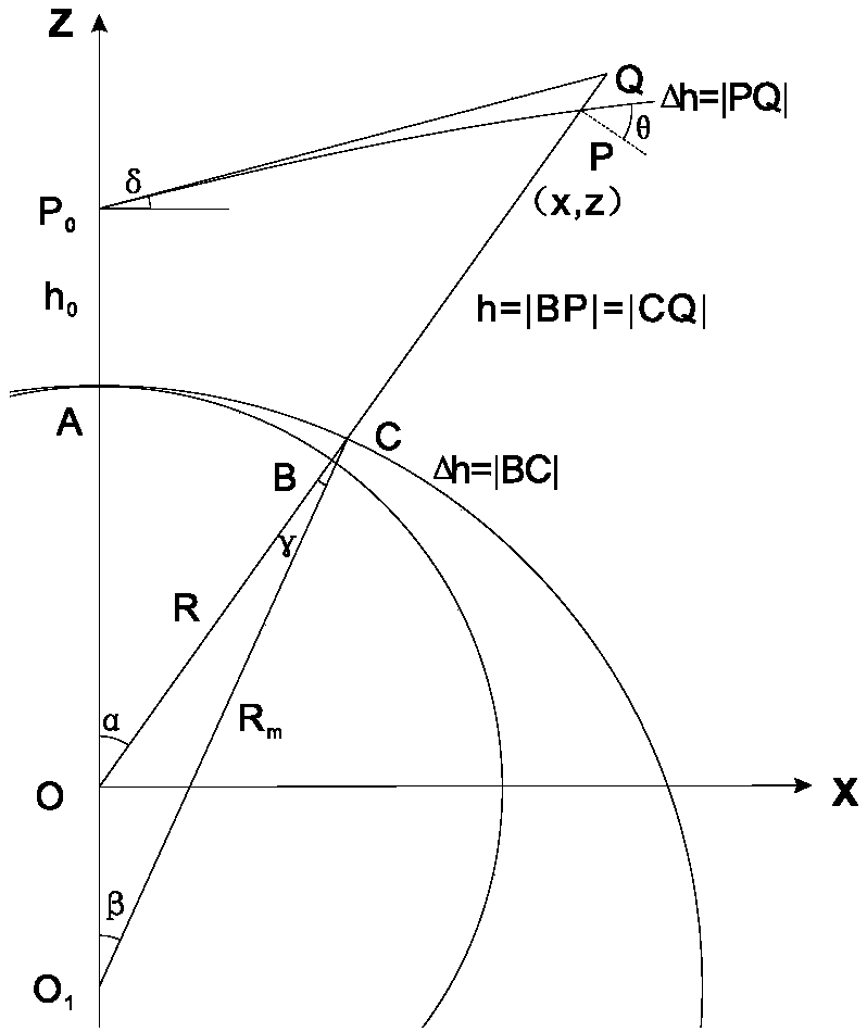
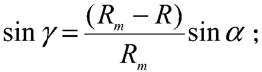
[0055] The dual-Doppler radar three-dimensional wind field inversion method of the present invention transforms the commonly used Cartesian coordinate system into a dynamic earth coordinate system, and at the same time, improves the wind field inversion grid points from equal XYZ grids to equal longitude and latitude and equal altitude grid. The corresponding relationship between the inversion results obtained in this way and the geographical location is simple...


PUM


Abstract

The invention relates to a double-Doppler radar three-dimensional wind field retrieval method. The method comprises the following steps that: a dynamic earth coordinate system is determined; a grid which is corresponding to the dynamic earth coordinate system and is equal to the dynamic earth coordinate system in longitude, latitude and altitude is adopted as a retrieval grid; the influence of atmospheric refraction on wind field retrieval is analyzed, so that an included angle between a radar beam at a target point and the horizontal plane of the target point is obtained; by means of the included angle between the radar beam at the target point and the horizontal plane of the target point, radial velocity with the influence of standard atmospheric refraction on vertical wind velocity projection considered is obtained; radial velocities observed by two radars on the same grid point, are approximated as horizontal wind vectors, and are synthesized, so that a resultant wind velocity is generated; and by means of a mass continuous equation and the falling velocity empirical formula of precipitation particles, iterative calculation is performed until the error of two iterations is smaller than a preset value, and finally the three-dimensional wind field of a precipitation echo region is obtained. According to the method of the invention, the influence of the standard atmospheric refraction on the double-radar wind field retrieval is considered, and the accuracy of the wind field retrieval can be improved.

Description

technical field [0001] The invention belongs to the technical field of atmospheric remote sensing monitoring and analysis, and in particular relates to a dual-Doppler radar three-dimensional wind field inversion method. Background technique [0002] Doppler radar uses the principle of Doppler frequency shift to measure the speed of precipitation particles moving closer or farther than the radar by measuring the frequency change between the electromagnetic waves reflected by the precipitation particles and the emitted electromagnetic waves. This speed is called radial speed. Since the true vector velocity of precipitation particles cannot be measured, the single radar is greatly limited in observing the wind field. In order to break through the limitation of single radar, researchers at home and abroad have developed a dual-Doppler radar wind field inversion technology, which is to synthesize the radial velocities observed by two Doppler radars at a certain distance, and use...

Claims


Application Information

Patent Timeline
IPC IPC(8): G01S13/95
CPCG01S13/95Y02A90/10
Inventor 罗昌荣池艳珍
Owner 厦门市气象灾害防御技术中心(海峡气象开放实验室
Why Eureka
Try Eureka