Well-to-seismic integration based horizontal well geosteering modeling method

A well-seismic combination and geosteering technology, applied in geographic modeling, seismology, geophysical measurement, etc., can solve problems such as the inability to meet the needs of geological understanding while drilling, and improve the accuracy of structural description and reservoir prediction. , The effect of improving the drilling rate of the oil layer and improving the drilling efficiency

Active Publication Date: 2018-05-08
CHINA PETROLEUM & CHEM CORP +4
View PDF6 Cites 14 Cited by
  • Summary
  • Abstract
  • Description
  • Claims
  • Application Information

AI Technical Summary

Problems solved by technology

Current technology does not meet the needs of geological understanding while ...

Method used


Image

  • Well-to-seismic integration based horizontal well geosteering modeling method
  • Well-to-seismic integration based horizontal well geosteering modeling method
  • Well-to-seismic integration based horizontal well geosteering modeling method

Examples


Embodiment Construction

[0026] In order to make the above and other objects, features and advantages of the present invention more comprehensible, the preferred embodiments are listed below and shown in the accompanying drawings in detail as follows.

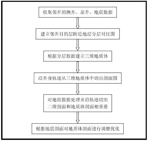
[0027] Such as figure 1 as shown, figure 1 It is a flow chart of the horizontal well geosteering modeling method combined with well and seismic of the present invention, and the application examples and effect analysis are as follows:

[0028] Step 1. Collect adjacent well data such as coordinates of adjacent wells, elevation, core height, logging curve, well deviation, drilling time, gas logging, lithology description, and small-scale 3D seismic data in the work area.

[0029] The well number, coordinates of adjacent wells, altitude and heart-filling height belong to the basic data, which are placed separately in the data module of the work area. Data such as well logging curve, well deviation, drilling time, gas logging and lithology are placed in ...


PUM


Abstract

The invention provides a well-to-seismic integration based horizontal well geosteering modeling method. The method includes a step 1 of collecting adjoining well data and three-dimensional seismic data in a small range of a working zone; a step 2 of performing stratum comparison according to the collected working zone adjoining well data and dividing into small layers; a step 3 of establishing a working zone three-dimensional digital geologic body by utilizing a common Kriging interpolation method according to the adjoining well layering data; a step 4 of cutting a two-dimensional profile mapfrom the three-dimensional geologic body along a well body track; a step 5 of cutting a two-dimensional profile along the well body track after treatment of three-dimensional seismic data by utilizinga time-depth relation in the working zone and performing overlapping display on the two-dimensional profile and the stratum model cut from the three-dimensional geologic body; a step 6 of adjusting the stratum body according to a form of an event of the seismic section so as to enable the stratum model form to fit the form of the seismic event. By adopting the method provided by the invention, the construction description precision and the reservoir predication accuracy are improved and a sound technique guarantee is provided for horizontal well geosteering.

Description

technical field [0001] The invention relates to the technical field of horizontal well geosteering, in particular to a horizontal well geosteering modeling method combined with well and seismic. Background technique [0002] With the development of oil drilling technology, oil and gas reservoirs that could not be commercially developed in the past due to reasons such as thin oil layers and poor recoverable properties can now be exploited by drilling horizontal wells. Especially in recent years, the development of coalbed methane and shale gas has higher and higher requirements for drilling technology. As a new drilling technology, horizontal well drilling technology has increased production and production efficiency, and effectively developed oil and gas reservoirs that were unavailable in the past. , are increasingly used in oil and gas drilling. In the process of horizontal well drilling in the oil and gas exploration and production department, how to guide the drill bit ...

Claims


Application Information

Patent Timeline
IPC IPC(8): G01V99/00G01V1/28
CPCG01V1/28G01V99/005G01V2210/66
Inventor 慈兴华盖姗姗宋明水马光强张迎春陈存元李萍
Owner CHINA PETROLEUM & CHEM CORP
Why Eureka
Try Eureka