Complex riverway terrain quick and fine generation method

A complex terrain and fast technology, applied in the space field of geographic information system, can solve the problems of terrain expression distortion, achieve the effect of solving the lack of data, improving the accuracy of data, and improving the accuracy of terrain interpolation

Active Publication Date: 2018-05-08
WUHAN UNIV
View PDF6 Cites 32 Cited by
  • Summary
  • Abstract
  • Description
  • Claims
  • Application Information

AI Technical Summary

Problems solved by technology

This method covers the three key technical links of river channel boundary generation, regional elevation sampling point encryption and supplementary monitoring section, and can effectively solve the problem of terrain expression distortion caused by insufficient elevation sampling points in high-precision terrain modeling

Method used


Image

  • Complex riverway terrain quick and fine generation method
  • Complex riverway terrain quick and fine generation method
  • Complex riverway terrain quick and fine generation method

Examples


Embodiment Construction

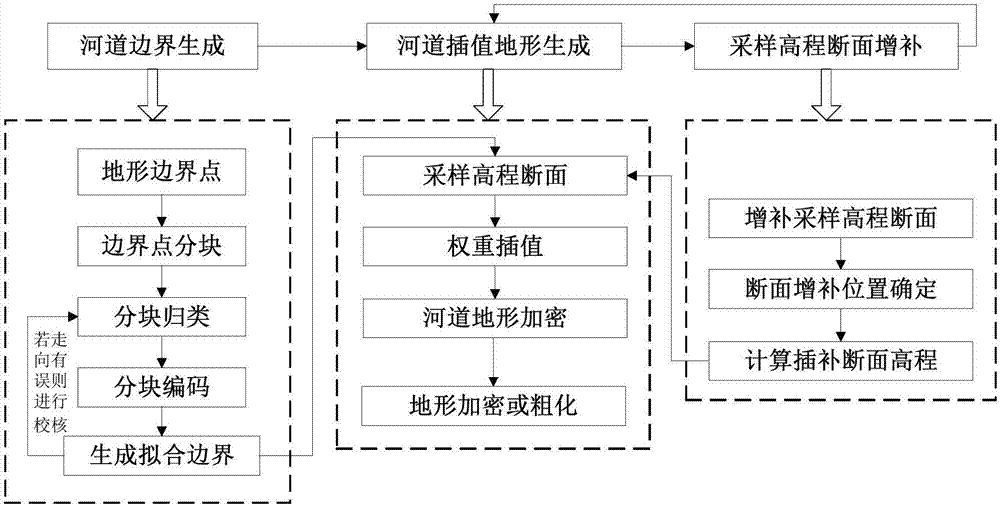
[0040] Below in conjunction with accompanying drawing, the present invention is described in further detail:

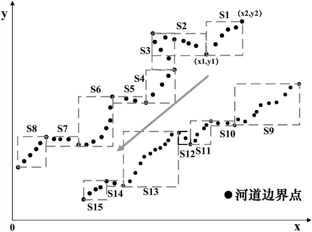
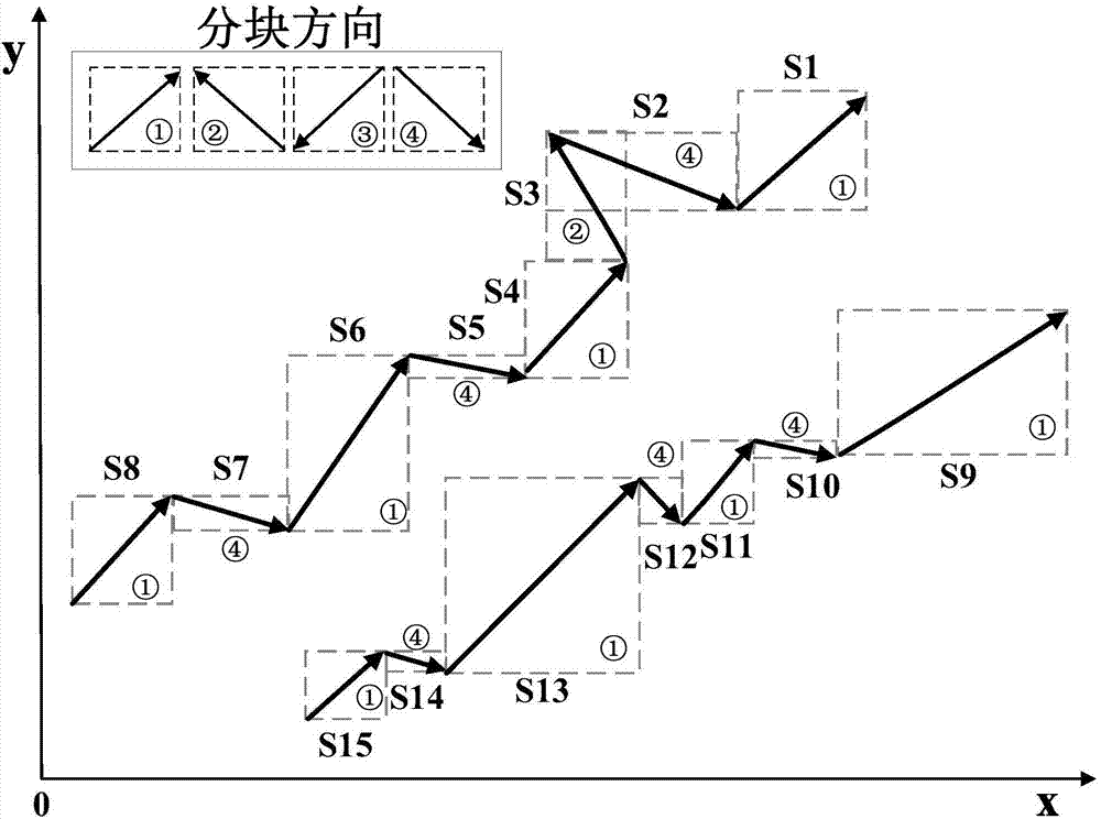
[0041] (1) Scattered point block coding of river boundary

[0042] ① Import the CAD terrain of the Daning River channel into GIS for processing: the line layer needs to be processed, including the processing of the river boundary and the processing of its connection with the main stream. First, edit the river boundary layer in GIS. For places where a few complex small branches exist, the boundary line can be smoothed to facilitate subsequent interpolation. Secondly, in the left window of GIS, right click on "Layers", select "Properties-Coordinate system-Predefined-Projected coordinatesystems-UTM-WGS 1984-Northern Hemisphere-WGS 1984UTM Zone 49N", complete the WGS1984 coordinate system to WGS 1984UTM Zone 49N coordinates Coordinate transformation of the system.

[0043] ② Line to point: In the GIS toolbox "Data management Tools-Features-Feature to point", the line la...


PUM


Abstract

The invention discloses a complex riverway terrain quick and fine generation method. By performing unified block division, classification and numbering on spatial relationships of complex terrain boundary points, scattered boundary points are fitted with a natural riverway course and a new riverway boundary is generated, so that the problem of disorder of a large amount of boundary points of a riverway is solved; through a finite riverway monitoring section terrain, based on a weight interpolation method, quick generation of a riverway terrain is realized; and the terrain is generated throughriverway interpolation, and accurate supplement of a riverway section is realized by utilizing a distance between a to-be-supplemented section and a known sampling elevation section of the riverway, and a gradient change. According to a characteristic that the scattered boundary points of the riverway and terrain elevation sampling data cannot meet riverway hydrodynamic calculation precision requirements, the modes of riverway boundary fitting, riverway terrain interpolation and riverway sampling elevation section supplement are adopted, the characteristics of the natural riverway course and the terrain change are fully considered, and the terrain interpolation errors are effectively reduced.

Description

technical field [0001] The invention belongs to the field of geographic information system space technology, and relates to the fitting of river topography, in particular to a method for quickly and finely generating complex river topography. Background technique [0002] The digital elevation model (DEM) is a spatial data model that describes the morphological characteristics of the surface relief. It is a matrix composed of regular grid point elevation values ​​on the surface, forming a grid structure data set. In the numerical simulation of hydrodynamics and water environment, it is very important to calculate whether the terrain value on the calculation grid can reflect the real terrain, which will directly affect the calculation accuracy. DEM is the reproduction of the actual topographical surface, and its credibility to terrain expression depends to a large extent on the distribution and density of elevation sampling points. However, elevation sampling points cannot o...

Claims


Application Information

Patent Timeline
Patent Type & Authority Applications(China)
IPC IPC(8): G06T11/20G06F17/30
CPCG06F16/29G06T11/206
Inventor 张万顺程美玲彭虹王永桂
Owner WUHAN UNIV
Why Eureka
Try Eureka