Plant sampling system based on unmanned aerial vehicle
A technology of sampling system and unmanned aerial vehicle, which is applied in the direction of control/regulation system, motor vehicle, sampling device, etc., can solve the problems of manpower and material resources, inaccurate sampling positioning, and inaccurate sampling point positioning, etc., to save manpower and material resources , Improve work efficiency, improve the effect of sampling efficiency
- Summary
- Abstract
- Description
- Claims
- Application Information
AI Technical Summary
Problems solved by technology
Method used
Image
Examples
Embodiment 1
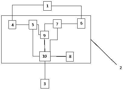
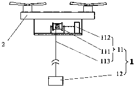
[0042] as attached figure 1 , attached figure 2 As shown, a plant sampling system based on UAV 2 includes plant sampling device 1, UAV 2 and ground base station 3; plant sampling device 1 is installed on UAV 2; UAV 2 includes an airborne control system The airborne control system is connected with the plant sampling device 1, and the airborne control system communicates with the ground base station 3 wirelessly.
[0043] A plant sampling system disclosed in the present invention relies on UAV 2 technology, which can realize the mechanization and automation of plant sampling, improve work efficiency, save manpower and material resources, and can improve the accuracy of data collection and detection results.
[0044] In order to further optimize the above-mentioned technical scheme, the plant sampling device 1 includes a lifting device 11 and a sampler 12; connect.
[0045] The plant sampling device 1 disclosed in the present invention can be easily installed on the UAV 2, a...
Embodiment 2
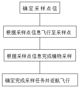
[0074] like image 3 Shown is a kind of plant sampling system based on unmanned aerial vehicle 2 that the present invention discloses and carries out the workflow of plant sampling, comprises the following steps:
[0075] (1) Determine the sampling point information: UAV 2 flies to the pre-set sampling area, collects images through the image acquisition module 8, and converts the image information into digital signals, and passes the data transmission module on the airborne end and the data transmission module on the ground. The image information is transmitted to the ground base station 3, and the positioning information of the sampling point and the height information of the sampling point are determined through the image analysis and screening of the ground base station 3, and then the positioning information of the sampling point and the height information of the sampling point are transmitted to the UAV 2 Airborne control system;
[0076](2) Fly to the sampling point acc...
PUM
 Abstract
Description
Claims
Application Information
 - R&D
- Intellectual Property
- Life Sciences
- Materials
- Tech Scout
- Unparalleled Data Quality
- Higher Quality Content
- 60% Fewer Hallucinations
Browse by: Latest US Patents, China's latest patents, Technical Efficacy Thesaurus, Application Domain, Technology Topic, Popular Technical Reports.
© 2025 PatSnap. All rights reserved.Legal|Privacy policy|Modern Slavery Act Transparency Statement|Sitemap|About US| Contact US: help@patsnap.com


