

Borehole radar imaging method based on non-uniform spectrum estimation
A borehole radar and spectrum estimation technology, which is applied in the direction of radio wave reflection/re-radiation, using re-radiation, and measurement devices, can solve the problems of restricting the application of borehole radar, high computational complexity, and low imaging efficiency, and achieve Avoid the effect of large-scale calculation, high imaging accuracy, and stable imaging performance
- Summary
- Abstract
- Description
- Claims
- Application Information
AI Technical Summary
Problems solved by technology
Method used
Image

Examples
Embodiment 1
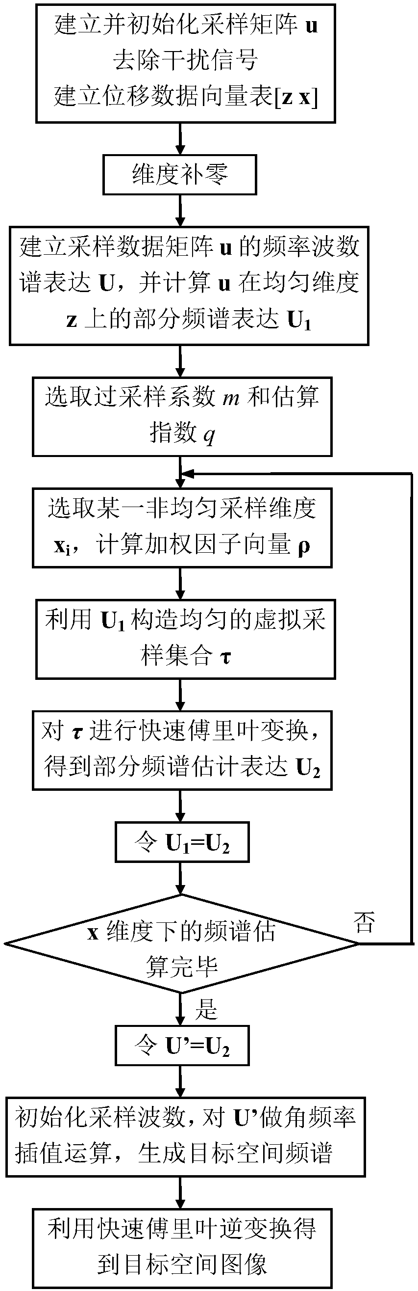
[0046] Such as figure 1 As shown, the present invention comprises a kind of borehole radar imaging method based on non-uniform frequency spectrum estimation, comprises the following steps:
[0047] Step A, initializing the borehole radar sampling data and establishing a displacement data vector table;
[0048] Step B, using the spectrum estimation algorithm to quickly obtain the spectrum of the non-uniform spatial sampling data;
[0049] Step C, performing an interpolation operation on the estimated frequency spectrum of the sampling data obtained in the previous step to obtain the target spatial frequency spectrum;
[0050] Step D, obtaining the target space image.
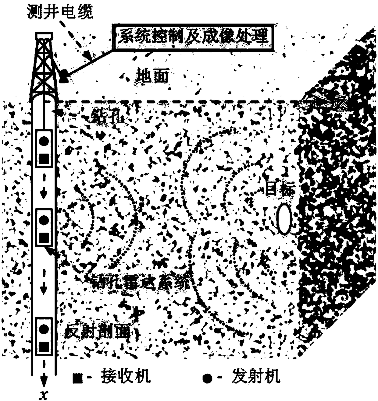
[0051] During the working process of the borehole radar, the time-driven radar system will inevitably rub against the wellbore wall when moving along the wellbore, resulting in uneven spatial sampling of the system along the wellbore direction, thereby affecting the high efficiency of the target space. Imaging...
Embodiment 2
[0055] In this embodiment, on the basis of Embodiment 1, the specific implementation steps are described by taking two-dimensional borehole radar detection as an example, preferably as follows: obtaining the sampling data of the borehole radar in step A includes the following steps:
[0056] A1. Use the borehole radar system to sample the radar echoes of the medium around the well, and establish a non-uniform sampling data matrix u of several dimensions. The expression of u is as follows
[0057]
[0058] Use sliding filtering to remove the direct wave signal and other crosstalk signals in the non-uniform sampling data matrix, and at the same time use the positioning system to measure the position of the downhole system and record the displacement information, and establish the displacement data vector table [z x] of the corresponding dimension, including the uniform sampling dimension set z and non-uniform sampling dimension set x, where z and x are both single-dimensional ...
Embodiment 3
[0061] This embodiment is preferably as follows on the basis of the above-mentioned embodiments: in step B, the specific steps of using the spectrum estimation algorithm to quickly obtain the frequency spectrum of the non-uniform spatial sampling data are as follows:
[0062] B1. Establish the frequency wavenumber spectrum expression U of sampling data matrix u, wherein
[0063]
[0064] is the element of matrix U, Δx n is the actual sampling interval on the x dimension, Δx is the average sampling interval on the x dimension, n'=-N / 2+1,...,N / 2, l'=-L / 2+1,...,L / 2 , perform fast Fourier transform on all uniformly sampled dimension sets z of the sampled data matrix, and obtain partial spectral representations under uniformly sampled dimensions
[0065] B2. Comprehensively consider the estimation error and computational complexity of the frequency wavenumber spectrum of the sampling data matrix, and select an appropriate oversampling coefficient m and estimation index q;
...
PUM
| Property | Measurement | Unit |
|---|---|---|
| Drilling diameter | aaaaa | aaaaa |
| Depth | aaaaa | aaaaa |
Abstract
Description
Claims
Application Information