Inertia measurement information-assisted star map matching method

A technology of inertial measurement and matching method, which is applied to measuring devices, navigation through speed/acceleration measurement, surveying and navigation, etc., which can solve the problems of low matching efficiency and many times of redundant matching

Active Publication Date: 2018-06-29
NANJING UNIV OF AERONAUTICS & ASTRONAUTICS
View PDF2 Cites 7 Cited by
  • Summary
  • Abstract
  • Description
  • Claims
  • Application Information

AI Technical Summary

Problems solved by technology

Therefore, the number of redundant matching

Method used


Image

  • Inertia measurement information-assisted star map matching method
  • Inertia measurement information-assisted star map matching method
  • Inertia measurement information-assisted star map matching method

Examples


Embodiment

[0127] The embodiment is based on the following simulation environment: the inertial navigation system is used as a part of the GPS / INS integrated navigation system, and the integrated navigation system is a loose combination of the speed and position of GPS and INS, and uses the indirect feedback Kalman filter estimation method to estimate the position and posture. Corrections to position and attitude information are provided by the output of the filter. The simulation parameters and track settings of the integrated navigation system are as follows:

[0128] Assuming that the aerospace vehicle is doing maneuvering flight, the simulated flight time is 3600s. Its flight trajectory contains various flight states such as climbing, speed change, level flight and turning, and its flight trajectory is as follows: Figure 5 shown. The initial position of the aerospace vehicle is 20° north latitude, 110° east longitude, and an altitude of 500m; its initial speed is 0m / s, and its hea...


PUM


Abstract

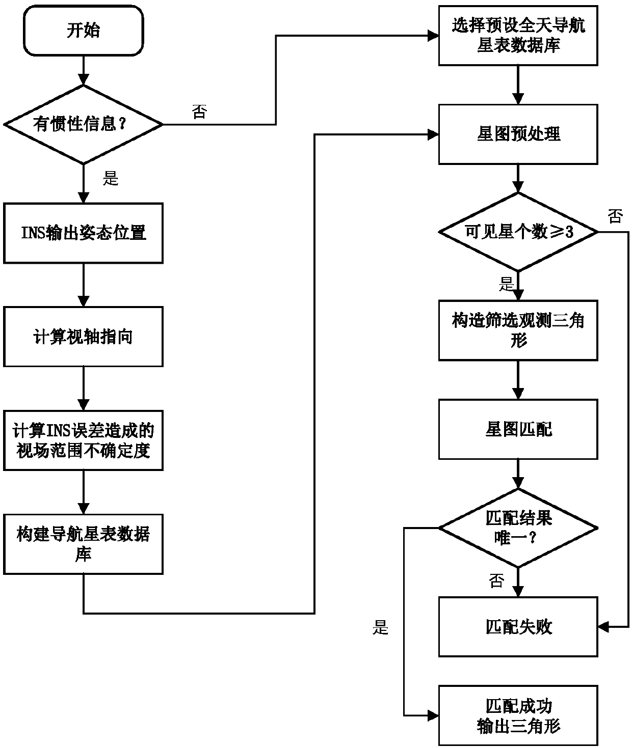
The invention discloses an inertia measurement information-assisted star map matching method, which comprises the steps of utilizing position information and attitude information output by an inertialnavigation system or an integrated navigation system comprising the inertial navigation system for determining a visual axis orientation of a current star sensor; reducing visual axis uncertainty caused by a navigation system error into a view field radius; dynamically screening navigation stars of current moment to form a navigation star catalogue; then utilizing a triangle matching method for carrying out star map matching. Compared with an existing star map matching method, the robustness and the efficiency of the method provided by the invention are improved.

Description

technical field [0001] The invention belongs to the field of autonomous navigation of aerospace vehicles, and in particular relates to a star map matching method assisted by inertial measurement information. Background technique [0002] At present, any single navigation method cannot provide long-term reliable navigation guarantee for aerospace vehicles with complex mission requirements. Under the current technical conditions, the research on the navigation system configuration of aerospace vehicles mostly takes the inertial / astronomical integrated navigation system as the necessary navigation means. The existing inertial / astronomical integrated navigation research believes that celestial navigation can obtain high-precision starlight vector information for attitude measurement through star map recognition, so as to calibrate the gyro drift of the inertial navigation system online, and effectively improve the integrated navigation system through indirect feedback filtering ...

Claims


Application Information

Patent Timeline
IPC IPC(8): G01C21/02G01C21/16G01C21/20
CPCG01C21/02G01C21/165G01C21/20
Inventor 曹宇轩王融刘建业熊智闵艳玲殷德全景羿铭
Owner NANJING UNIV OF AERONAUTICS & ASTRONAUTICS
Why Eureka
Try Eureka