
Bionic polarization/inertial/atmospheric data integrated navigation system

A technology that combines navigation system and atmospheric data, applied in navigation, navigation through speed/acceleration measurement, mapping and navigation, etc., can solve the problem of low accuracy and reliability of a single navigation method, low accuracy of a single navigation system, and anti-interference ability. It can achieve the effect of strong data processing capability, reduced system processing delay, and high autonomy

Active Publication Date: 2018-07-20
郭晓宇
View PDF5 Cites 19 Cited by
  • Summary
  • Abstract
  • Description
  • Claims
  • Application Information

AI Technical Summary

Problems solved by technology

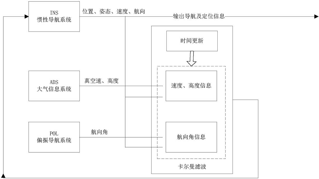
[0009] The technical problem to be solved by the present invention is: to overcome the shortcomings of a single navigation system such as low precision and poor anti-interference ability, use polarization navigation, atmospheric data system and inertial navigation for pattern matching, and perform bionic polarization / atmosphere / inertial autonomous navigation; When the signal is interfered or difficult to obtain, use atmospheric aided navigation and inertial navigation for pattern matching to perform atmospheric aided / inertial autonomous navigation; when not relying on inertial navigation information, the heading angle information provided by the polarization sensor and the speed provided by the atmospheric data system , altitude information for pattern matching, path integration, and independent calculation of position information to achieve multi-mode autonomous integrated navigation with strong environmental adaptability. Using the principles of bionics and integrated navigation, it overcomes the shortcomings of low accuracy and reliability of single navigation means

Method used


Image

  • Bionic polarization/inertial/atmospheric data integrated navigation system
  • Bionic polarization/inertial/atmospheric data integrated navigation system
  • Bionic polarization/inertial/atmospheric data integrated navigation system

Examples


Embodiment Construction

[0021] The present invention will be further described below in conjunction with the accompanying drawings and specific embodiments.

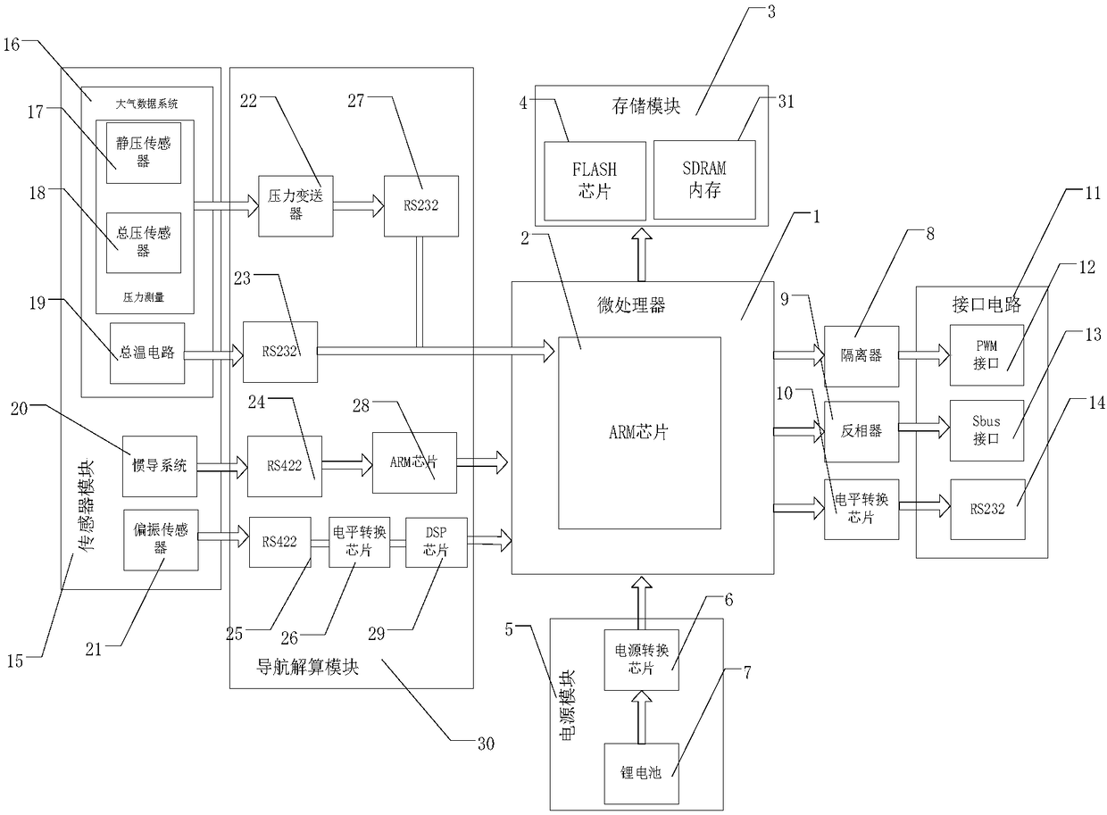
[0022] Such as figure 2 Shown is a block diagram of the structure of the present invention, that is, a multi-mode bionic polarization / atmospheric data integrated navigation system. A bionic polarization / inertial / atmospheric data combined navigation system of the present invention includes a sensor module 15 , a navigation solution module 30 , an interface circuit 11 , a microprocessor 1 , a storage module 3 and a power supply module 5 . Wherein, the sensor module 15 includes a polarization sensor 21, an inertial navigation system 20 and an air data system 16 composed of a static pressure sensor 17, a total pressure sensor 18 and a total temperature circuit 19, and the navigation solution module 30 includes a pressure transmitter 22, a pressure The RS232 interface 27 of the transmitter, the RS232 interface 23 of the total temperature circuit, th...


PUM


Abstract

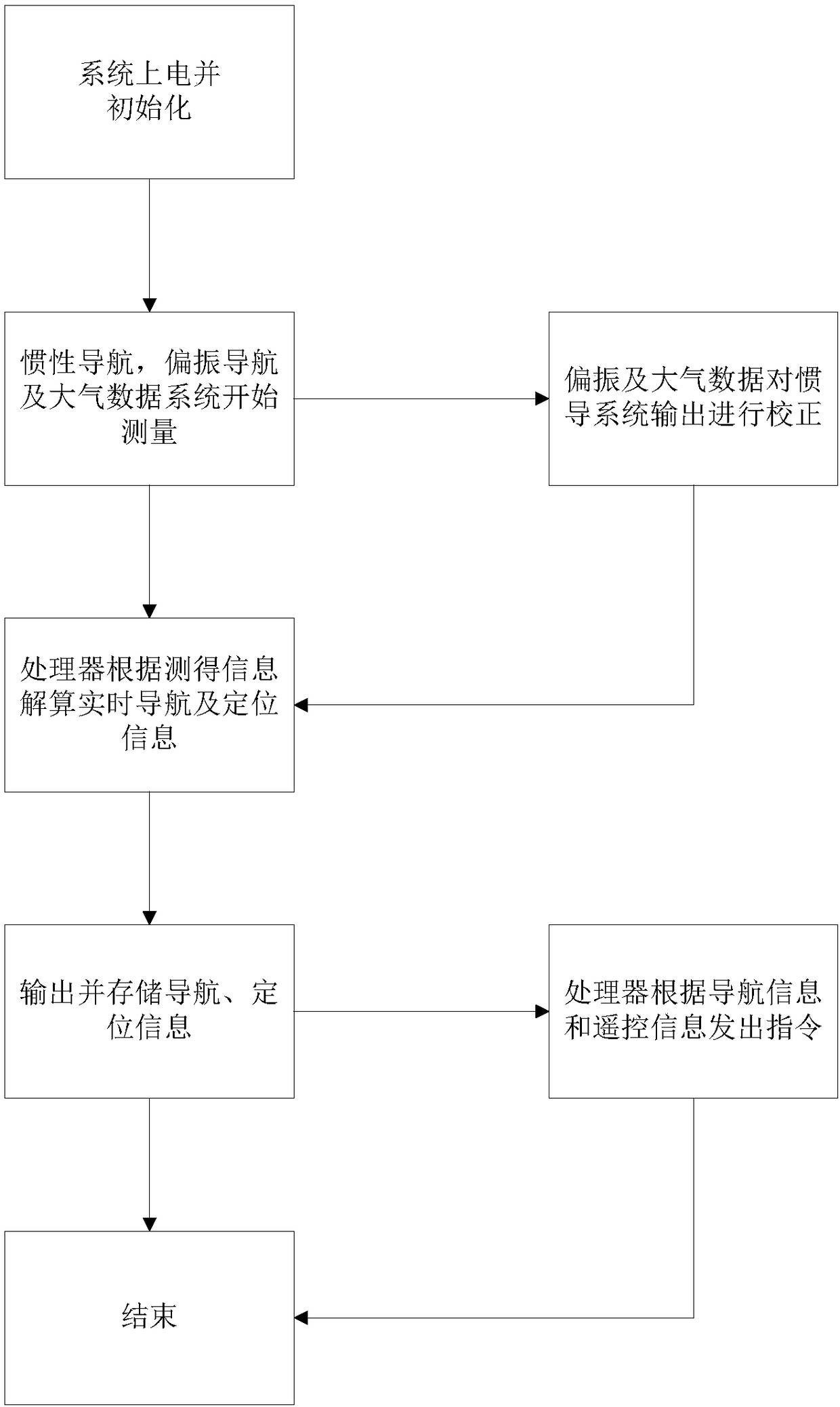
The invention relates to a bionic polarization / inertial / atmospheric data integrated navigation system. The system consists of a navigation sensor, a solving module, an interface circuit, a microprocessor, a storage module and a power supply module. The sensor is composed of a biomimetic polarization sensor, an inertial measurement unit and an atmospheric data system. Specifically, the bionic polarization sensor includes an optical camera, a motor, a polarizing device and other components, and the atmospheric data system is composed of a pitot-static sensor, a pitot-static pipeline and a totaltemperature circuit. The work flow includes that: the sensor module collects the polarized light information, atmospheric static pressure, full pressure and other data in the atmospheric environment,and transmits the data to the solving module, and the processor determines whether the sensor works reliably, selects a working mode, and works out the course angle, true airspeed, height and other information for compensation correction of the attitude and speed of the navigation system, and stores and outputs navigation parameters. The integrated navigation system provided by the invention has the advantages of flexible navigation mode, strong autonomy, small volume and the like, and has interference suppression, fault detection and system reconstruction functions.

Description

technical field [0001] The invention relates to the technical field of integrated navigation, in particular to a bionic polarization / inertial / air data integrated navigation system. Background technique [0002] Navigation is the technology of measuring and estimating the physical quantities such as the position, velocity, and attitude of the carrier and moving body to guide the equipment from one point to the target point. Integrated navigation uses information sources of various navigation sensors to complement each other to form a multi-functional system with redundancy and high navigation accuracy. It is one of the cutting-edge technologies and key areas of national science and technology development. Inertial / satellite combination (INS / GNSS) navigation technology is currently the most widely used integrated navigation method. However, GNSS satellite navigation signals are vulnerable to special environments such as radio stations, relay stations, radar stations, and even...

Claims


Application Information

Patent Timeline
IPC IPC(8): G01C21/16G01C21/20
CPCG01C21/165G01C21/20
Inventor 郭晓宇
Owner 郭晓宇
Learn More