Unmanned vessel ant colony energy consumption optimal global path planning method based on electronic nautical chart

A technology of global path planning and electronic charts, applied in the fields of artificial life, electrical digital data processing, non-electric variable control, etc., can solve the problem of not guaranteeing the optimal energy consumption of unmanned boats

Active Publication Date: 2018-08-17
HARBIN ENG UNIV
View PDF5 Cites 22 Cited by
  • Summary
  • Abstract
  • Description
  • Claims
  • Application Information

AI Technical Summary

Problems solved by technology

Under the influence of ocean currents, the optimal distance in the gene...

Method used


Image

  • Unmanned vessel ant colony energy consumption optimal global path planning method based on electronic nautical chart
  • Unmanned vessel ant colony energy consumption optimal global path planning method based on electronic nautical chart
  • Unmanned vessel ant colony energy consumption optimal global path planning method based on electronic nautical chart

Examples


Embodiment Construction

[0075] The present invention will be described in more detail below with examples in conjunction with the accompanying drawings.

[0076] 1. Electronic chart conversion

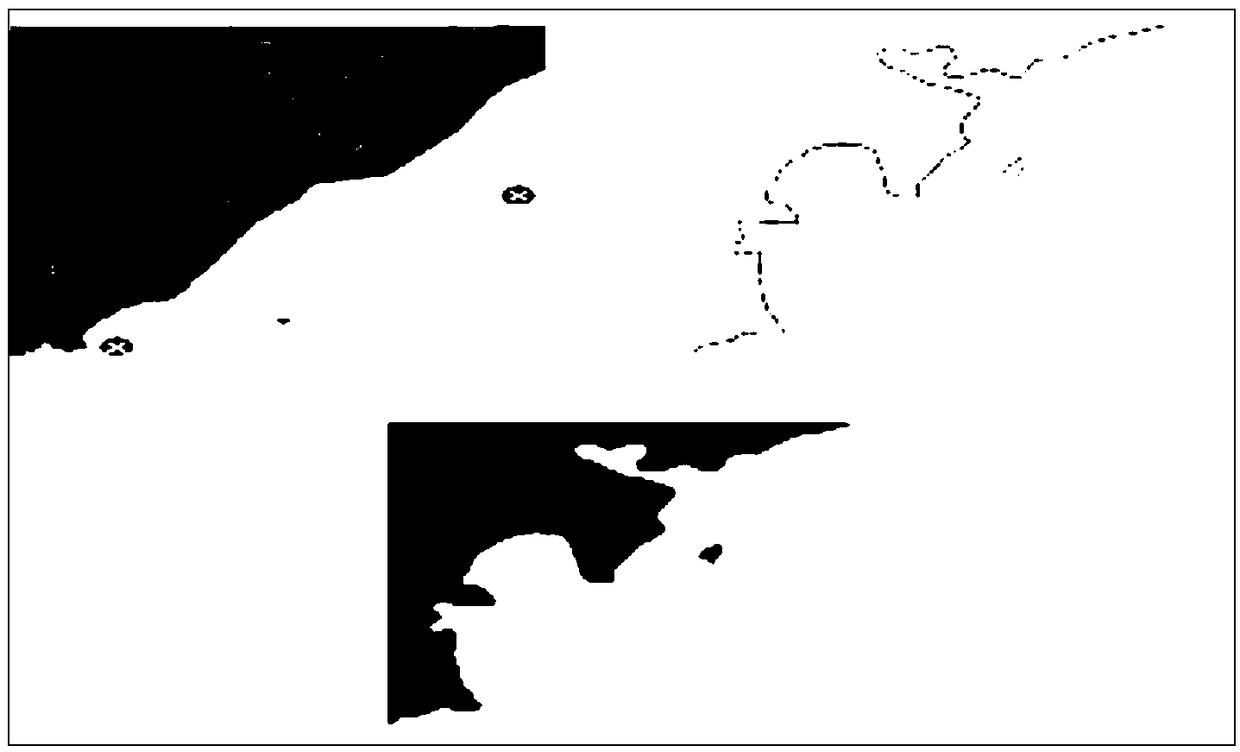
[0077] Convert the S-57 electronic chart into shape format and .jpg format. Before performing environmental modeling with the visualization method, the converted format should be further processed, so that it can be edited and processed by matlab software: first, use the graythresh function Automatically determine the binarization threshold, and then use the im2bw function to binarize the image. The infeasible area is processed as black, and the parameters in the corresponding X-Y coordinate system are marked as 0, and the feasible area is white, marked as 1, so as to convert the image Separate different areas in (such as figure 2 ).

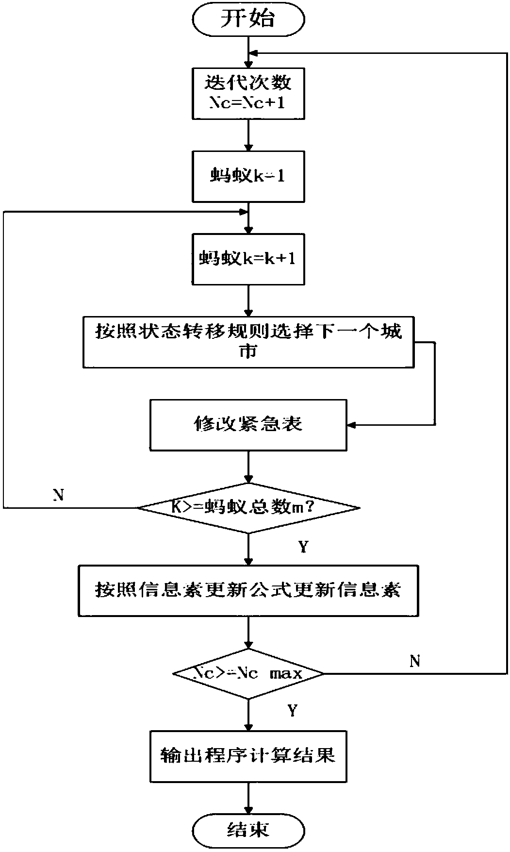
[0078] Using the visualization method to model the environment, first find the vertices of the obstacles, plus the coordinates of the starting point and the target point, an...


PUM


Abstract

The invention provides an unmanned vessel ant colony consumption optimal global path planning method based on an electronic nautical chart. The method comprises the steps of 1, processing the electronic nautical chart, wherein after the electronic nautical chart is converted into the form of a file capable of being processed, a feasible area and an obstacle area of a map are determined, a visibility graph method is utilized to find out a set of feasible paths among an initial point, a target point and the vertex of an obstacle, it is guaranteed that the paths do not pass through an unfeasiblearea, and the sailing safety of the unmanned surface vessel is guaranteed; 2, building a motion math model, wherein the motion model of an unmanned vessel is built, and thus the thrust and motion characteristics of the unmanned vessel are grasped; 3, obtaining unmanned vessel data, wherein when the unmanned vessel sails on the water surface, information data like the heading, the vehicle body position and vertical acceleration of the vehicle is obtained; 4, utilizing an ant colony algorithm to search for a track meeting requirements; 5, building an unmanned surface vessel energy consumption model under ocean current disturbance, wherein with the optimal energy consumption being the premise, the ant colony algorithm is improved to obtain the path satisfying safe sailing conditions and having the smallest energy consumption. By comparing the paths under two preconditions, the effectiveness of the designed algorithm is proved.

Description

technical field [0001] The invention relates to a global path planning method for an unmanned boat, in particular to an optimal global path planning method for ant colony energy consumption of an unmanned boat on an electronic chart. Background technique [0002] In the navigation system of unmanned surface vehicles, path planning is one of the most important tasks, and the global path is an important subject, which is very important for the research of unmanned surface vehicles. The electronic chart contains detailed chart information; the visual map method can find out the set of feasible paths between the starting point, the target point and the obstacle vertices in the map; the ant colony algorithm has good positive feedback and robustness, and can find A path that meets certain requirements. Under the influence of ocean currents, the optimal distance in the general sense does not guarantee the optimal energy consumption of unmanned boats. Contents of the invention ...

Claims


Application Information

Patent Timeline
IPC IPC(8): G06F17/50G06N3/00G05D1/08
CPCG05D1/0875G06N3/006G06F30/20Y02A90/10
Inventor 王元慧沈佳颖田怡婧赵亮博刘向波
Owner HARBIN ENG UNIV
Why Eureka
Try Eureka