Aircraft route planning method and system based on identification point visual navigation and SINS (strap-down inertial navigation system)

A visual navigation and path planning technology, applied in the fields of positioning technology and path planning, navigation technology, and control engineering technology, it can solve problems such as long path planning time, inability to adapt to dynamic changes of optimization targets, and inability to achieve predetermined planned path flight.

Active Publication Date: 2018-08-21
UNIV OF SCI & TECH LIAONING
View PDF7 Cites 8 Cited by
  • Summary
  • Abstract
  • Description
  • Claims
  • Application Information

AI Technical Summary

Problems solved by technology

[0003] Traditional path planning methods such as dynamic programming, A* algorithm, etc. need to search the entire flight space, and the effect of parallel processing is poor; algorithms such as Voronoi diagram, simulated annealing algorithm, genetic algorithm and neural network cannot adapt to the dynamic changes of the optimization target, and the path planning time Long, often used in offline

Method used


Image

  • Aircraft route planning method and system based on identification point visual navigation and SINS (strap-down inertial navigation system)
  • Aircraft route planning method and system based on identification point visual navigation and SINS (strap-down inertial navigation system)
  • Aircraft route planning method and system based on identification point visual navigation and SINS (strap-down inertial navigation system)

Examples


Embodiment Construction

[0112] The specific implementation manners provided by the present invention will be described in detail below with reference to the accompanying drawings.

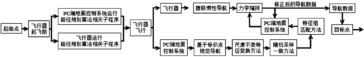
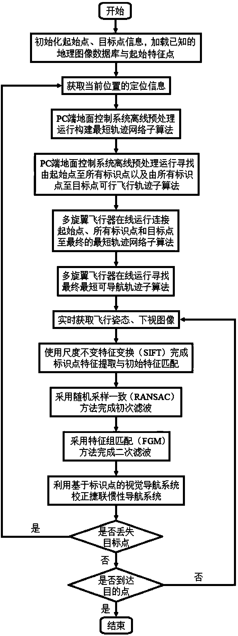
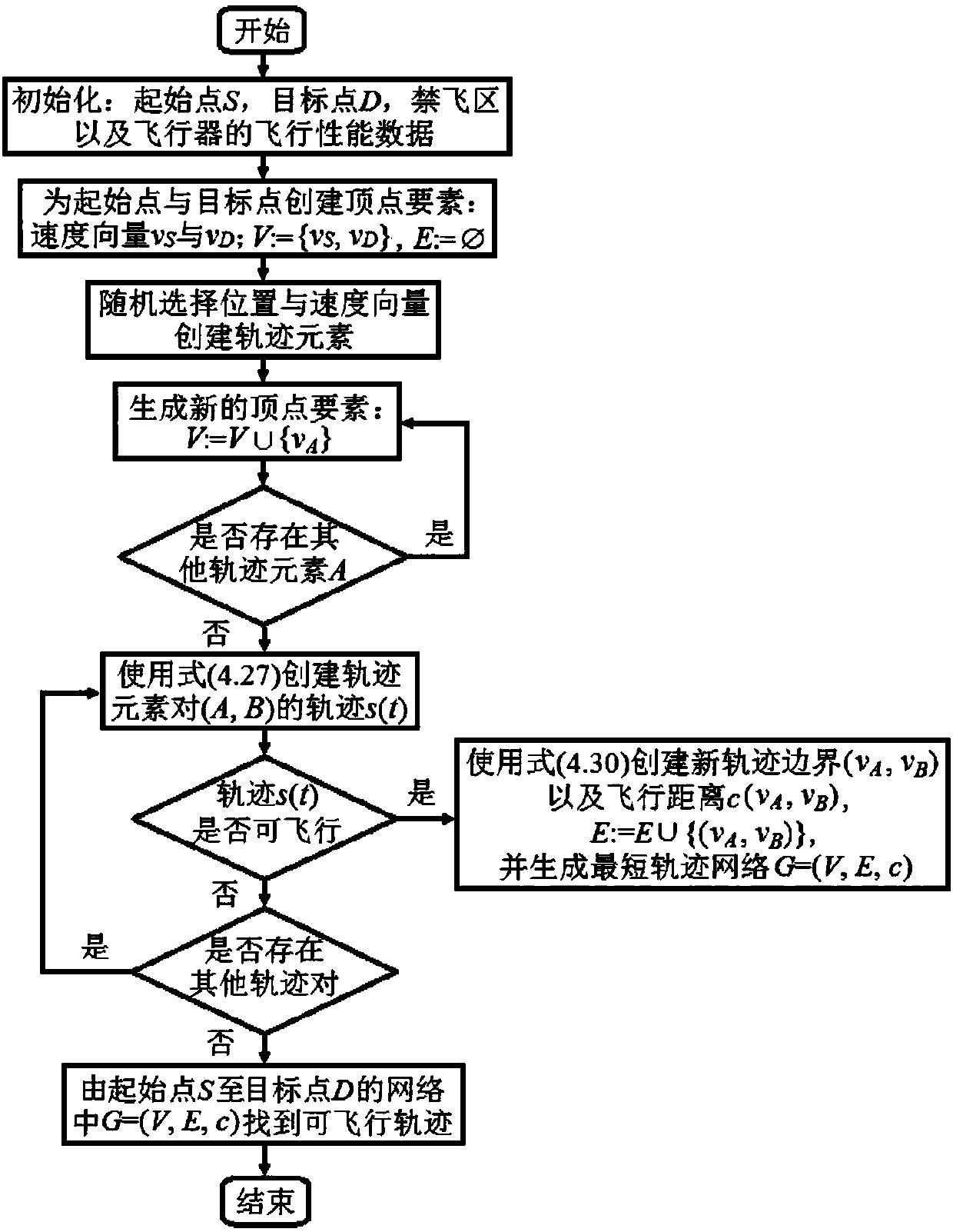
[0113] Such as figure 1 As shown, an aircraft path planning system based on mark point visual navigation and SINS includes the main flight control system of multi-rotor aircraft, strapdown inertial navigation system and PC-side ground control system, the main flight control system of multi-rotor aircraft, The strapdown inertial navigation system is placed at the intersection of the rotor supports of the multi-rotor aircraft, which is the theoretical centroid position of the multi-rotor aircraft; the visual navigation system based on the marking point runs on the PC-side ground control system; the strapdown inertial navigation system communicates with the multi-rotor via the SPI interface. The main flight control system of the multi-rotor aircraft is connected, and the main flight control system of the multi-rotor aircraft es...


PUM

PropertyMeasurementUnit
Diameteraaaaaaaaaa

Abstract

The invention provides an aircraft route planning method and system based on identification point visual navigation and an SINS (strap-down inertial navigation system). An integrated navigation systemcombining identification point based visual navigation with strap-down inertial navigation is adopted to obtain the route planning of the shortest navigable track for a multi-rotor aircraft in a no-fly zone and other complex terrain environments, and remote control of the multi-rotor aircraft, acquisition of real-time images and flight attitudes and real-time back transmission of positioning information are realized through a ground control system of a PC side; the identification point based visual navigation technology and the inertial navigation technology are used to constitute the integrated navigation system, and accurate positioning of the multi-rotor aircraft is realized. The identification point based visual navigation of the aircraft is realized by comparing relative positions ofidentification points in real-time acquired images and onboard pre-stored reference images, and the aircraft route planning method and system have the advantages of being low in cost, high in accuracy, capable of realizing remote control and applicable to indoor, outdoor, two-dimensional and three-dimensional space environments and the like. Tests prove that the accuracy of the route planning system and method reaches +/-10 cm.

Description

Technical field [0001] The invention relates to the technical fields of control engineering technology, navigation technology, positioning technology and path planning, in particular to an aircraft path planning method and system based on marking point visual navigation and SINS. Background technique [0002] In the fields of mobile robots and aircraft, transportation networks, 3D path planning and dynamic shortest path problems, path planning is a hot topic, and its technical basis is precise positioning. At present, Inertial Navigation System (INS), Global Positioning System (GPS) and visual navigation are the most widely used navigation systems. INS is an autonomous navigation system that uses inertial sensors (gyro and accelerometer), reference azimuth, and initial position information to determine the carrier’s position, position, and speed. It is usually divided into Platform Inertial Navigation System (PINS) and Czechoslovakia. There are two types of Strap-down Inertial N...

Claims


Application Information

Patent Timeline
IPC IPC(8): G01C21/16G01C21/20
CPCG01C21/165G01C21/20
Inventor 史添玮崔文华周自维张文宇代红王介生陶冶温馨李冀宁范舒悦张钊
Owner UNIV OF SCI & TECH LIAONING
Why Eureka
Try Eureka