Unmanned aerial vehicle directional navigation method, GNSS receiver device and GNSS receiver system

A technology for directional navigation and unmanned aerial vehicles, which is applied to satellite radio beacon positioning systems, radio wave measurement systems, measurement devices, etc. to reduce complexity, resolve inconsistencies in flight area overlap, and improve accuracy.

Pending Publication Date: 2018-09-14
GUANGZHOU HI TARGET NAVIGATION TECH
View PDF3 Cites 14 Cited by
  • Summary
  • Abstract
  • Description
  • Claims
  • Application Information

AI Technical Summary

Problems solved by technology

[0011] In order to overcome the deficiencies in the prior art, the object of the present invention is to provide a UAV directional navigation method, a GNSS receiver device, and a GNSS receiver system, aiming at solving the problem that the prior art cannot accurately carry out directional navigation for autonomous flight routes

Method used


Image

  • Unmanned aerial vehicle directional navigation method, GNSS receiver device and GNSS receiver system
  • Unmanned aerial vehicle directional navigation method, GNSS receiver device and GNSS receiver system
  • Unmanned aerial vehicle directional navigation method, GNSS receiver device and GNSS receiver system

Examples


specific Embodiment 1

[0045] An embodiment of the present invention provides a method for directional navigation of an unmanned aerial vehicle, comprising:

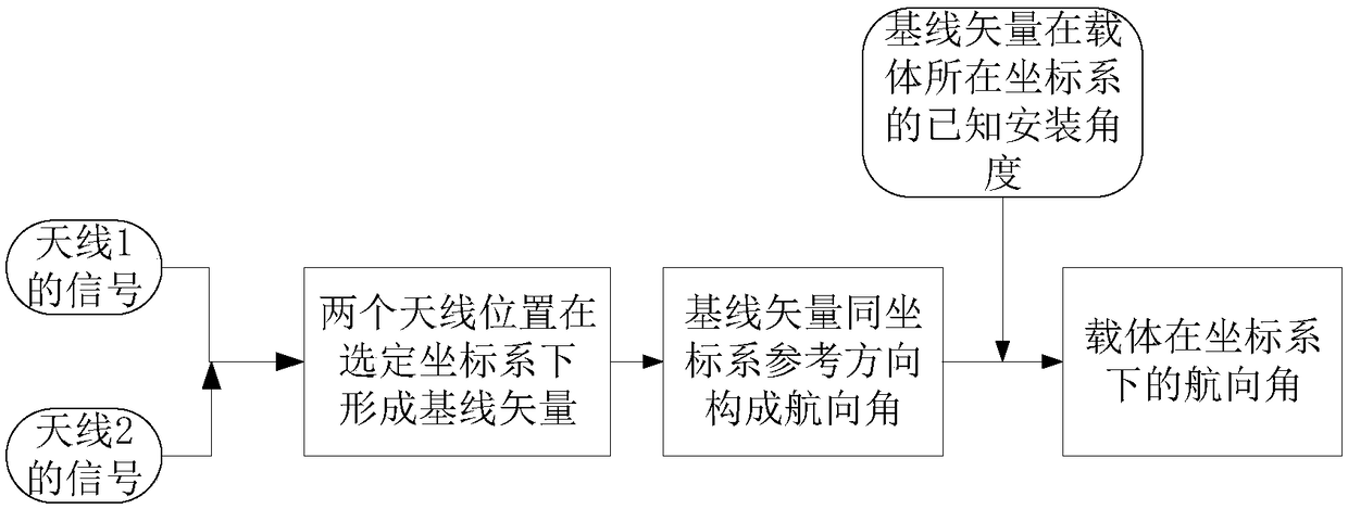
[0046] The satellite calculation step is to receive the satellite signal sent by the first GNSS satellite receiving antenna, and obtain the position information of the first GNSS satellite receiving antenna through calculation; and receive the satellite signal sent by the second GNSS satellite receiving antenna, and obtain the second GNSS satellite through calculation The location information of the receiving antenna;

[0047]Orientation solution step, according to the position information of the first GNSS satellite receiving antenna, the position information of the second GNSS satellite receiving antenna, calculate the baseline vector formed by the first GNSS satellite receiving antenna and the second GNSS satellite receiving antenna, obtain the orientation of the baseline vector Result; then according to the baseline vector and the installa...

specific Embodiment 2

[0054] like Figure 4 As shown, the embodiment of the present invention provides a GNSS receiver device, including a GNSS satellite signal calculation unit, an orientation navigation calculation unit, a positioning navigation calculation unit, a differential data calculation unit, and a positioning orientation navigation result generation unit;

[0055] The GNSS satellite signal calculation unit is respectively connected with the first GNSS satellite receiving antenna and the second GNSS satellite receiving antenna; the positioning and orientation navigation result generation unit is connected with the UAV flight control system;

[0056] The GNSS satellite signal calculation unit, the orientation and navigation calculation unit, and the positioning and orientation navigation result generation unit are sequentially connected; the GNSS satellite signal calculation unit, the positioning and navigation calculation unit, and the positioning and orientation navigation result generati...

specific Embodiment 3

[0065] like Figure 5 As shown, the embodiment of the present invention provides a kind of unmanned aerial vehicle orientation navigation GNSS receiver system, including:

[0066] The GNSS receiver device in the specific embodiment two;

[0067] The first GNSS satellite receiving antenna;

[0068] Second GNSS satellite receiving antenna.

[0069] The two GNSS satellite receiving antennas transmit the received satellite signals to the GNSS satellite signal calculation unit for calculation to obtain their respective position coordinates, and the directional navigation calculation unit calculates the baseline vector formed by the two antennas according to the respective positions of the two antennas, and Gives the heading angle in a selected coordinate system. Since the baseline distance of the dual antennas is very, very small compared to the distance between the antenna position and the satellite position, the position calculation of the two antennas has a high correlation. ...


PUM


Abstract

The invention discloses an unmanned aerial vehicle directional navigation method, a GNSS receiver device and a GNSS receiver system. The system comprises the GNSS receiver device, a first GNSS satellite receiving antenna and a second GNSS satellite receiving antenna, wherein the GNSS receiver device comprises a GNSS satellite signal processing unit, a directional navigation processing unit, a positioning navigation processing unit, a differential data processing unit and a positioning and directional navigation result generating unit. Two GNSS receiving antennas are adopted to provide autonomous difference and offset common errors; through a lengthened baseline mounting mode of the two antennas on an unmanned aerial vehicle carrier, the directional navigation precision is improved; due tothe positioning difference processing, the measurement accuracy of a dual-antenna baseline vector is improved; due to the accurate directional navigation, various and optimized autonomous flight routes can be designed; the integration and the independence of the module are improved, a product can be formed easily, and the productibility is improved; and accurate course navigation for the unmannedaerial vehicle carrier can be realized, and the problem of inconsistency flight area overlapping between flight routes can be solved.

Description

technical field [0001] The invention relates to the technical field of directional navigation of unmanned aerial vehicles, in particular to a method for directional navigation of unmanned aerial vehicles, a GNSS receiver device, and a GNSS receiver system. Background technique [0002] With the development and maturity of drone-related technologies, its uses are becoming more and more extensive, such as agricultural plant protection, urban management, geological survey, meteorological monitoring, power inspection, emergency rescue and disaster relief, aerial photography, video shooting and other industries. Industrial applications have higher and higher requirements for the accuracy of drone navigation, especially in the agricultural and plant protection industry, which greatly improves operational efficiency and reduces labor costs through autonomous flight routes. [0003] In the agricultural plant protection industry, the purpose of autonomous route flight is to spray pes...

Claims


Application Information

Patent Timeline
Patent Type & Authority Applications(China)
IPC IPC(8): G01S19/41
CPCG01S19/41
Inventor 林钦坚周芝丽陈伟黄德福周敏
Owner GUANGZHOU HI TARGET NAVIGATION TECH
Why Eureka
Try Eureka