Optimum spectral index selection-based high-resolution satellite remote sensing image building extraction method
A satellite remote sensing image and spectral index technology, which is applied in the field of satellite remote sensing image processing and application, can solve the problems of ignoring spectral information and high complexity of extraction algorithm, and achieve the effect of improving accuracy
- Summary
- Abstract
- Description
- Claims
- Application Information
AI Technical Summary
Problems solved by technology
Method used
Image


Examples
Embodiment 1
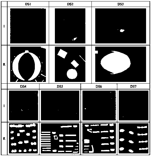
[0034] As shown in Table 1, WorldView-2 images with 0.46m multispectral resolution and 1.8m panchromatic resolution were used as the experimental data of 8-band high-resolution remote sensing images ( figure 2 ), including 7 test data (DS1-DS7), the experimental area is near the Huanglong Gymnasium in Hangzhou City, Zhejiang Province. The real building images of the experimental area were obtained through field observation and expert interpretation, and the results were used as the standard.
[0035] Table 1
[0036] High Resolution Satellite Remote Sensing Imagery
Spatial resolution (m)
Number of MSS bands
Experimental data
WorldView-2
PAN: 0.46, MSS: 1.8
8
DS1-DS7
[0037] Step 1: Image preprocessing
[0038] (a) Image fusion: use the complete remote sensing image processing platform (ENVI) to carry out the Gauss-Schmidt orthogonal transform fusion (Gram-Schmidt Pan Sharperening) method.
[0039] (b) Orthorectification: Accordin...
Embodiment 2
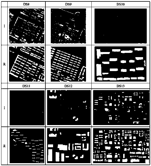
[0066] As shown in Table 3, the QuickBird image (0.61 m panchromatic resolution and 2.44 m multispectral resolution), domestic GF-1 (2 m panchromatic resolution and 8 m multispectral resolution) and GF-2 image (1 m panchromatic resolution and 4 m multispectral resolution) as the experimental data of 4-band high-resolution images ( Figure 4 ), including 6 test data (DS8-DS13, the coverage area is a relatively dense urban area.
[0067] table 3
[0068] image name
Spatial resolution (m)
Number of MSS bands
Experimental data
GF-1
PAN: 2, MSS: 8
4
DS8-DS9
GF-2
PAN: 1, MSS: 4
4
DS10-DS11
QuickBird
PAN: 0.61, MSS: 2.44
4
DS12-DS13
[0069] Step 1: Image preprocessing
[0070] (a) Radiation correction: use ENVI software to perform FLAASH correction (Fast Line-of-sight Atmospheric Analysis of Spectral Hypercubes) and radiation calibration processing, and convert the digital quantization value (DN) value...
PUM
 Abstract
Description
Claims
Application Information
 - R&D
- Intellectual Property
- Life Sciences
- Materials
- Tech Scout
- Unparalleled Data Quality
- Higher Quality Content
- 60% Fewer Hallucinations
Browse by: Latest US Patents, China's latest patents, Technical Efficacy Thesaurus, Application Domain, Technology Topic, Popular Technical Reports.
© 2025 PatSnap. All rights reserved.Legal|Privacy policy|Modern Slavery Act Transparency Statement|Sitemap|About US| Contact US: help@patsnap.com