
Eureka
For R&D, Eureka makes reading and utilizing patents & technical documents easy.
Eureka AIR
Designed for self-driven R&D workflows. Generate viable solutions, solve complex R&D challenges, empower your innovation with AI.

Eureka Materials
Designed for material experts only. Revolutionize your material R&D, from search, analyze, to developing new materials.

TechResearch
Generate reliable direction feasibility study reports for your R&D in just a few steps.

TechSeek
Discover and master advanced knowledge NOW. Basics, ideas, possibilities, all at once.

TechMind
As an expert in R&D Theories, TechMind can generates customized viable solutions instantly.

TechRisk
Analyze your overall solution with one click, know your potential R&D risks in advance.

TechMonitor
Get weekly tech updates, stay abreast of the latest tech innovations and key insights.
Device and method for cloud estimation of arbitrary tunnel internal point passing speed models
A technology of velocity model and tunnel model, which is applied in the direction of navigation, measurement device, and navigation calculation tool through velocity/acceleration measurement, which can solve the problems of increasing equipment cost, volume, and poor accuracy of forward velocity, etc., and achieve enhanced navigation position Estimated accuracy, effect of suppressing forward error divergence
- Summary
- Abstract
- Description
- Claims
- Application Information
AI Technical Summary
Problems solved by technology
Method used
Image

Examples
Embodiment 1
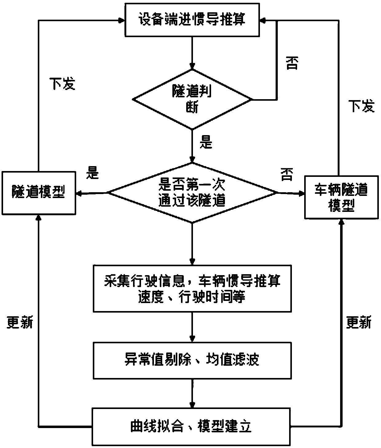
[0035] figure 1 It is a flow chart of the method for estimating the passing speed model of any point in the tunnel in the cloud according to the first embodiment of the present invention, including the following steps:
[0036] Step S1, collect tunnel data offline, collect a positioning point (real longitude and latitude point) at a certain distance (preferably 30m) in the tunnel, and then abstract the tunnel point map through the connectivity between points, preferably through GeoHash (or other ) coding method, which codes and indexes all tunnel points. GeoHash is a geographic information coding method.
[0037] Step S2, when the algorithm module in the vehicle judges that it is possible to enter the tunnel by detecting signal occlusion (GNSS signal loss), it sends the current latitude and longitude to the cloud, and the cloud will match the reported latitude and longitude with the tunnel point indexed in step S1. The speed model parameters of the tunnel, after the device en...
Embodiment 2
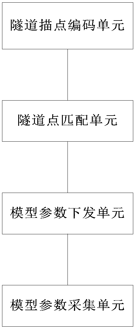
[0048] figure 2 It is a structural diagram of the method for estimating the passing speed model of any point in the tunnel in the cloud according to the first embodiment of the present invention, including:
[0049] The tunnel point encoding unit is used to encode the tunnel point map, and index all tunnel points through coding, and the tunnel point map is abstracted by positioning the connectivity between point points;
[0050] a tunnel point matching unit, configured to match based on the tunnel point and the latitude and longitude received by the cloud;
[0051] The model parameter sending unit is used to send the model parameters successfully after matching the tunnel point with the longitude and latitude received from the cloud;
[0052] The model parameter collection unit is used to collect vehicle tunnel model parameters of different vehicles to form a model set, perform mean filtering on the model set to obtain tunnel model parameters, and update the model parameters...
Embodiment 3
[0054] The present invention also provides a memory, the memory stores a computer program, and the computer program is executed by the processor as follows:
[0055] Collect tunnel data, and collect positioning points at intervals in the tunnel, that is, latitude and longitude points, abstract the tunnel point map through the connectivity between the point points, encode the point map of the tunnel, and index all tunnel points through coding;
[0056] After detecting that the GNSS signal is lost, the device determines that the vehicle has entered the tunnel, and reports the current latitude and longitude of the vehicle to the cloud. The cloud will match the received latitude and longitude with the indexed tunnel point. If the match is successful, the model parameters will be issued. If the match is unsuccessful Then the device continues to detect the GNSS signal;
[0057] After judging that the vehicle enters the tunnel, the device side continuously checks whether the GNSS sig...
PUM
 Abstract
Description
Claims
Application Information
 - R&D Engineer
- R&D Manager
- IP Professional
- Industry Leading Data Capabilities
- Powerful AI technology
- Patent DNA Extraction
Browse by: Latest US Patents, China's latest patents, Technical Efficacy Thesaurus, Application Domain, Technology Topic, Popular Technical Reports.
© 2024 PatSnap. All rights reserved.Legal|Privacy policy|Modern Slavery Act Transparency Statement|Sitemap|About US| Contact US: help@patsnap.com