Inertia/visual odometer combined navigation and positioning method based on measurement model optimization

A visual odometry and measurement model technology, applied in surveying and navigation, navigation through speed/acceleration measurement, navigation, etc., can solve the problem of difficult accurate modeling, ignoring the accumulation of visual odometry positioning errors, different motion estimation methods, etc. question

Active Publication Date: 2018-11-02
NANJING UNIV OF AERONAUTICS & ASTRONAUTICS
View PDF4 Cites 46 Cited by
  • Summary
  • Abstract
  • Description
  • Claims
  • Application Information

AI Technical Summary

Problems solved by technology

The motion estimation methods of various representative algorithms are different, and the relationship between the maneuvering of the moving body and the output pose noise is difficult to accurately model
Considering the complementarity of the two, integrated navigation based on inertial navigation and visual odometry has received extensive attention, but most of the existing integrated navigation of IMU and visual odometry directly use the combination of attitude and position, ignoring the positioning error of visual odometry Cumulative and maneuver-related features

Method used


Image

  • Inertia/visual odometer combined navigation and positioning method based on measurement model optimization
  • Inertia/visual odometer combined navigation and positioning method based on measurement model optimization
  • Inertia/visual odometer combined navigation and positioning method based on measurement model optimization

Examples


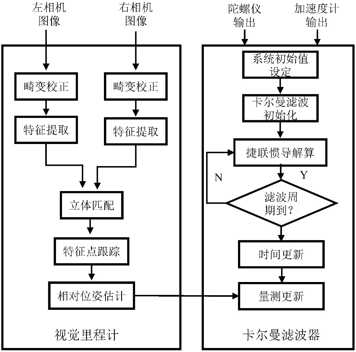
specific Embodiment approach

[0038] Step 1) establish the state equation of the inertial / visual odometer integrated navigation algorithm:

[0039] First define the coordinate system: the geographic coordinate system selects "East-North-Sky" as the navigation system (n), and the carrier coordinate system (b) selects "Right-Front-Up". The state quantity that needs to be estimated is shown in the formula:

[0040]

[0041] In the formula, X is the state vector, is the mathematical platform error angle in the SINS, The three-axis mathematical platform error angle of x, y, z respectively; δv n is the velocity error of the carrier, The velocity error of the carrier on the x, y, and z axes under the geographic system; δp n is the position error of the carrier, δL, δλ, and δh are the longitude, latitude, and height errors respectively; ε b is the random constant drift of the gyroscope, are the random constant drifts of the x, y, and z axes of the gyroscope; is the first-order Markov process drift o...


PUM


Abstract

The invention discloses an inertia / visual odometer combined navigation and positioning method based on measurement model optimization. A state equation of a combined navigation system is established,errors of an inertial sensor are expanded into system state variables including random constant drifting of a gyroscope, one-order markoff process drifting of the gyroscope and one-order markoff process drifting of an accelerometer; then, a visual odometer is taken as an angular velocity, linear velocity and position sensor to acquire measurement data, and a measurement equation is established; finally, in the carrier motion process, the navigation errors are fed back and corrected in real time, and a navigation result of an inertial navigation system after errors are corrected is obtained. According to the method, angular velocity, linear velocity and position information of the visual odometer can be effectively utilized in the carrier motion process, effective fusion with inertial navigation is realized, the accuracy and the reliability of the combined navigation system are improved, and the method is applicable to engineering applications.

Description

technical field [0001] The invention relates to an inertial / visual odometer combined navigation positioning method based on measurement model optimization, and belongs to the technical field of inertial / visual odometer combined navigation. Background technique [0002] In recent years, with the development of intelligent moving bodies such as drones, unmanned vehicles and robots, higher requirements have been placed on the performance of navigation systems. [0003] In the prior art, navigation systems widely used in intelligent moving bodies are mostly realized by inertial device (IMU-accelerometer and gyroscope) / satellite integrated navigation system. However, considering the environment where satellite signals are interfered or failed in cities, jungles, and indoors, it will be difficult for the IMU / satellite integrated navigation system to provide accurate navigation information. Visual odometry technology is a six-degree-of-freedom motion estimation method based on rel...

Claims


Application Information

Patent Timeline
Patent Type & Authority Applications(China)
IPC IPC(8): G01C21/16
CPCG01C21/165
Inventor 罗玮熊智李一博于永军邢丽万众许建新陈明星熊骏王钲淳张苗段胜青徐丽敏景羿铭孙瑶洁李文龙
Owner NANJING UNIV OF AERONAUTICS & ASTRONAUTICS
Why Eureka
Try Eureka