,Method of importing CAD data based on GIS into SWMM

A data import and data technology, applied in ICT adaptation, electrical digital data processing, special data processing applications, etc., can solve the problems of difficult measurement of specific parameters of the storm flood model, imperfect data import, etc., and achieve non-destructive transformation and parameter determination , save a lot of time and reduce the effect of human measurement error

Active Publication Date: 2018-12-07
SHENYANG JIANZHU UNIVERSITY
View PDF6 Cites 10 Cited by
  • Summary
  • Abstract
  • Description
  • Claims
  • Application Information

AI Technical Summary

Problems solved by technology

This software is mainly based on calculation functions, but it is not perfect in data import, which has caused great difficulties in the establishment of stormwater models and the measurement of specific parameters
At present, only commercial software and a small number of scholars can solve the problem of data import through programming, but the above methods are difficult to promote and use

Method used


Image

  • ,Method of importing CAD data based on GIS into SWMM
  • ,Method of importing CAD data based on GIS into SWMM
  • ,Method of importing CAD data based on GIS into SWMM

Examples


Embodiment Construction

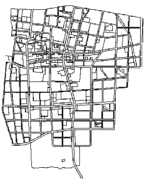
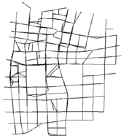
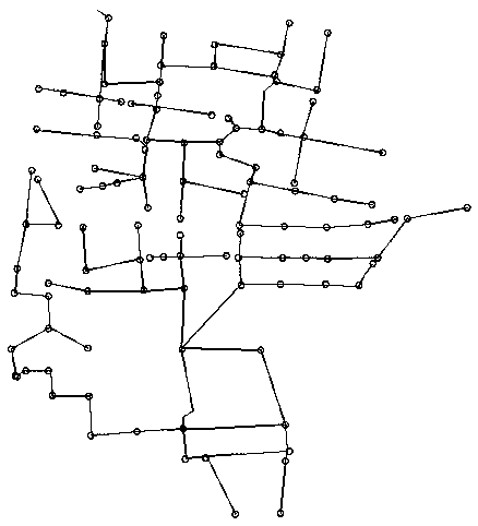
[0051] combine figure 1 , data import is carried out with the CAD engineering drawing data of city A, and its CAD engineering data includes: elevation point data, node data, pipeline data, and catchment area data.

[0052] The data processing tools used include: EPA SWMM 5.1007, ArcGIS 10.1, AutoCAD 2010, Excel and Notepad programs.

[0053] Pre-processing of CAD data:

[0054] Before the CAD data is imported, the original data needs to be deleted, and only the elevation point data, inspection well data, pipeline data and catchment area data required for modeling are kept, and then the pipeline data is divided into different layers according to the diameter of the pipeline , and classify the different land use properties in the catchment area by layers so that GIS can read and assign values ​​to different layers uniformly.

[0055] data verification:

[0056] Create a File Geodatabase file geographic information database under ArcMap, and create a Feature dataset feature da...


PUM


Abstract

The invention relates to the technical field of rainwater drainage, in particular to a method of importing CAD data based on GIS into SWMM. The method includes the following steps: step 1, pre-processing CAD data, deleting and classifying the data before importing so as to be used by GIS; step 2, conducting data verification to verify whet that topological relationship between the node and the pipeline is correct; step 3, conducting GIS data extraction and calculation: including node data extraction, pipeline data extraction, catchment data extraction; step 4, importing that data into the SWMMmodel; step 5, carrying out result and parameter analysis: testing and simulating the imported model. The method has the beneficial effects of saving the SWMM modeling time of the CAD and GIS data sources, improving the model data precision, reducing the human error, realizing the lossless conversion and realizing the parameter determination of the node bottom hole elevation, the characteristic width of the catchment area, the average slope, the water storage quantity of the depression, the impermeability percentage and the like.

Description

technical field [0001] The invention belongs to the technical field of municipal engineering and rainwater drainage, in particular to a method for importing GIS-based CAD data into SWMM. Background technique [0002] SWMM is a free simulation software in the design and management of urban stormwater and sewage. The software is mainly based on calculation functions, but it is not perfect in the import of data, which has caused great difficulties in the establishment of stormwater models and the measurement of specific parameters. At present, only commercial software and a small number of scholars can solve the problem of data import through programming, but the above methods are difficult to promote and use. Therefore, in order to provide a reference for data import, this paper studies a method of using ArcGIS to import data into SWMM and measure the parameters. Contents of the invention [0003] In order to solve the above-mentioned technical problems, the present invent...

Claims


Application Information

Patent Timeline
Patent Type & Authority Applications(China)
IPC IPC(8): G06F17/30
CPCY02A90/10
Inventor 蒋白懿牟天蔚李博叶友林王玲萍沈丹玉赵洪宾
Owner SHENYANG JIANZHU UNIVERSITY
Why Eureka
Try Eureka