Urban road network traffic estimation method and system
A technology of urban road network and transportation, applied in the field of intelligent transportation, can solve problems such as inability to guarantee the accuracy of traffic estimation, reduce computational complexity, and high computational complexity
- Summary
- Abstract
- Description
- Claims
- Application Information
AI Technical Summary
Problems solved by technology
Method used
Image
Examples
Embodiment 1
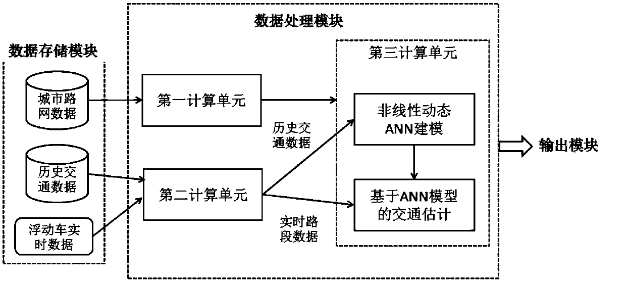
[0061] This embodiment specifically illustrates the implementation of the system of the present invention. The system of the present invention is as figure 1 Shown, including:
[0062] a. Data storage module; The data storage module stores urban road network data, historical traffic data, and real-time floating car traffic sampling data. The real-time floating car traffic sampling data includes floating car traveling speed and geographic location information. The stored data can be stored using Hadoop's distributed data storage system to facilitate efficient parallel computing and processing in the cluster.
[0063] b. Data processing module; for data processing, including a first calculation unit, a second calculation unit and several third calculation units;
[0064] b1. The first computing unit reads the urban road network data from the data storage module, and expresses the urban road network as a graph structure that can be used for computer storage, processing and analysis, tha...
Embodiment 2
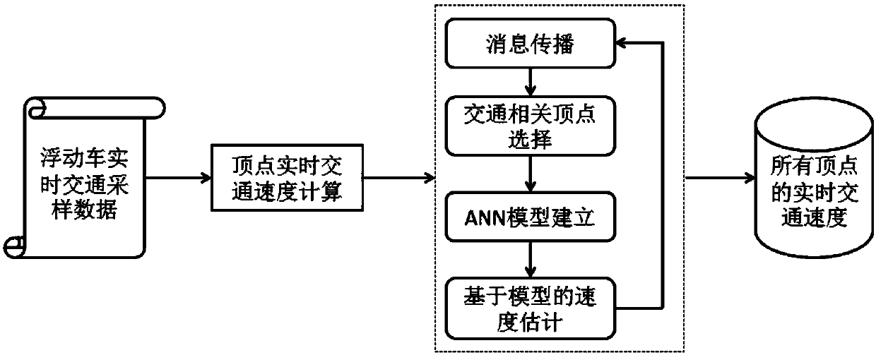
[0101] This embodiment specifically describes the implementation of the method of the present invention, including the following steps:
[0102] S100 obtains real-time traffic sampling data and historical traffic data of a floating car in a city-wide area; the traffic sampling data includes the traveling speed of the floating car, geographic location information, time, vehicle number, and driving direction;
[0103] S200 establishes an urban road network map with point edge attributes based on urban road network information;
[0104] Model road segments as vertices of the graph. For two directly connected road segments, create an edge between their corresponding vertices; vertex attributes include the current road segment’s traffic speed and road location information;
[0105] Based on the geographic location information of the road segment, S300 divides the urban road network graph into a number of point-edge sets composed of vertices and edges. Each point-edge set retains the vertice...
PUM
 Abstract
Description
Claims
Application Information
 - R&D
- Intellectual Property
- Life Sciences
- Materials
- Tech Scout
- Unparalleled Data Quality
- Higher Quality Content
- 60% Fewer Hallucinations
Browse by: Latest US Patents, China's latest patents, Technical Efficacy Thesaurus, Application Domain, Technology Topic, Popular Technical Reports.
© 2025 PatSnap. All rights reserved.Legal|Privacy policy|Modern Slavery Act Transparency Statement|Sitemap|About US| Contact US: help@patsnap.com


