A method for producing and distributing color topographic map

A topographic map and color technology, applied in the field of geographic information, can solve the problems of various forms of carrying files, large and complex production systems, and lack of space and time semantics, and achieve integration and visualization, wide application scenarios, and convenient data acquisition. Effect

Active Publication Date: 2018-12-25
中国科学院电子学研究所苏州研究院
View PDF2 Cites 8 Cited by
  • Summary
  • Abstract
  • Description
  • Claims
  • Application Information

AI Technical Summary

Problems solved by technology

However, today there are still many problems in terms of topographic map data sources, map accuracy, data quality, and service efficiency: network topographic map services based on geographic information transmission and expression of spatial entities have different forms in different industries and fields. Time semantics is seriously lacking, the expression object is incomplete, the scale is inaccurate, the carrying file forms are various, and the production system is huge and complex. At the same time, high-precision network topographic map service production and remote sensing technology, digital image processing technology, big data Parallel processing technology is closely related, and also requires the support and cooperation of different industries such as surveying and mapping, urban construction, aerospace, etc. Therefore, the early single topographic map data production method can no longer meet the existing comprehensive needs, and an efficient, accurate and convenient topographic map service is proposed It is very important to change the mode

Method used


Image

  • A method for producing and distributing color topographic map
  • A method for producing and distributing color topographic map
  • A method for producing and distributing color topographic map

Examples


Embodiment Construction

[0091] Below in conjunction with accompanying drawing, technical scheme of the present invention is described in further detail:

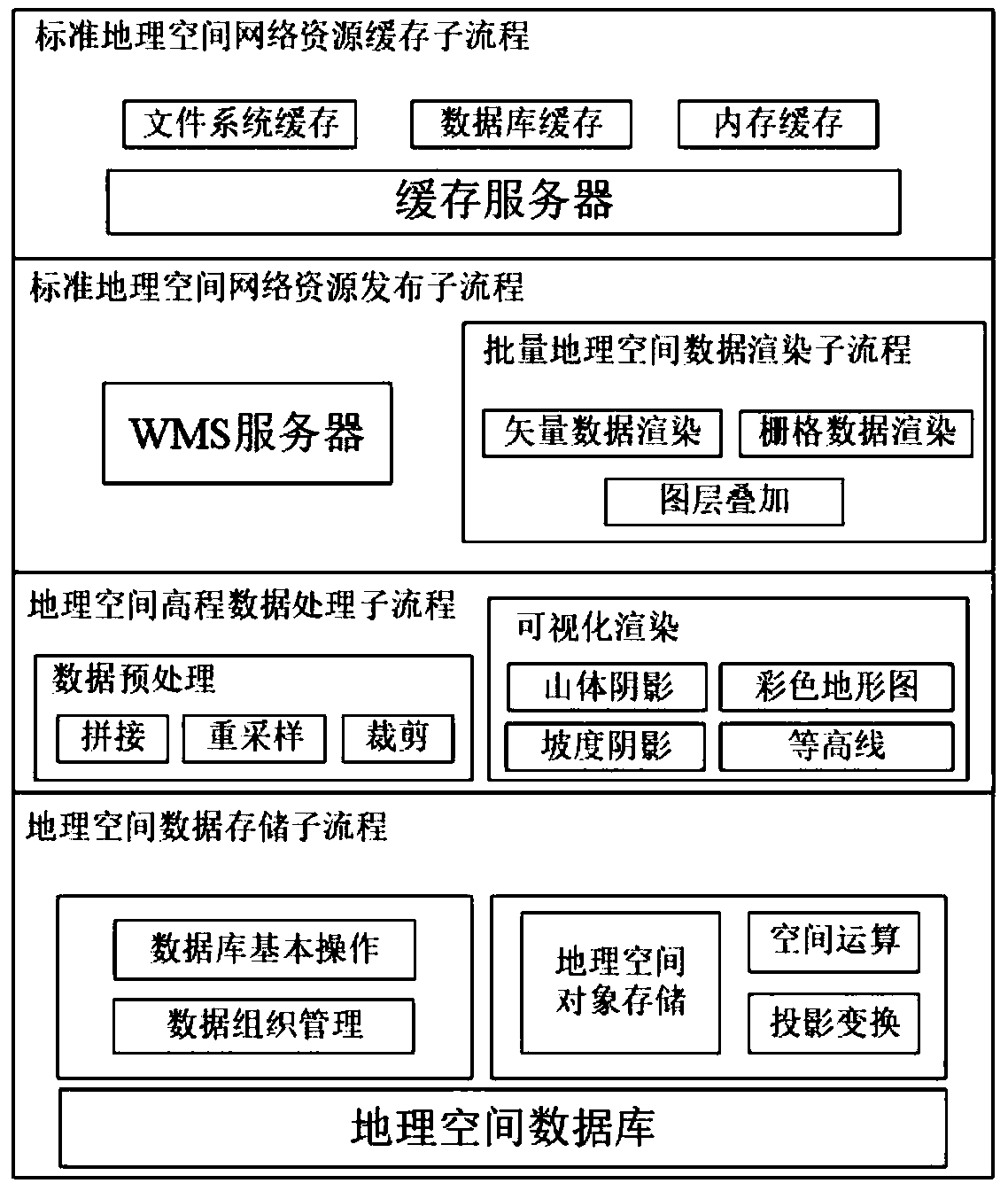
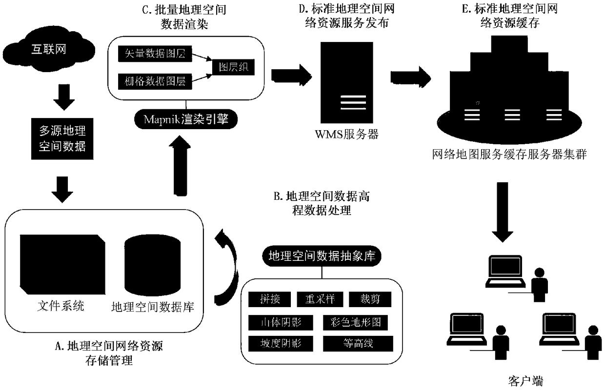
[0092] The present invention realizes a complete set of color terrain based on geospatial network resources by integrating geospatial data storage technology, elevation data processing technology, batch geospatial data rendering technology, standard geospatial network resource service publishing and caching technology, etc. Graph production and distribution schemes, such as figure 1 shown. Attached below figure 2 Specific embodiments of the present invention will be described in detail.

[0093] The implementation steps of the geospatial data storage management sub-process are as follows:

[0094] Geospatial data import

[0095] The geospatial vector data and raster data obtained from the network are imported into the geospatial database, and the data projection information is defined according to the different data sources when importing.

...


PUM


Abstract

A method for producing and distributing color topographic map based on the integration and support of geographic information technology is disclosed in the invention. The method presents the geospatial network resource storage management, Digital Elevation Data Processing, Batch Geospatial Data Rendering, Standard Geospatial Network Resource Service Publishing, Standard Geospatial Network ResourceCaching and other sub-processes, through the relevant processing flow, achieves the rapid production of topographic map data hierarchical block, and provides a standard online topographic map publishing and access methods. The invention is mainly used for integrating geospatial data service resources, combining data characteristics such as digital orthophoto image, digital elevation, vector map,etc., designing related data processing flow, generating clear and accurate topographic map data and service, and improving terrain data production and access efficiency.

Description

technical field [0001] The invention belongs to the technical field of geographic information, and mainly relates to a method for producing and distributing color topographic maps. Background technique [0002] In today's society with the rapid development of the Internet industry and information technology, geographic information technology-related industries have also developed rapidly, and various network map services have gradually become an important support for geographic information technology and big data platform technology. The network map service based on Internet resources is an important part of the public basic geographic information platform, and the basic geographic information carried is rich and diverse, which is convenient for people to recognize geographic space more intuitively. Topographic map data, as an important part of geographic information network map services, is a multi-dimensional geographic information network service released after the organi...

Claims


Application Information

Patent Timeline
IPC IPC(8): G06F17/30G06T17/05G06T15/60G06T15/00
CPCG06T15/00G06T15/60G06T17/05G06T2200/32
Inventor 付琨朱利鲁苏晓露林殷王马鑫曹阳
Owner 中国科学院电子学研究所苏州研究院
Why Eureka
Try Eureka