Full-automatic road roller location method based on multi-source data fusion

A multi-source data and positioning method technology, applied in the direction of electromagnetic wave re-radiation, measuring devices, instruments, etc., can solve problems such as inability to work, insufficient stability, weakened GPS signals, etc., to solve poor positioning accuracy, improve labor productivity, Avoid the effect of missing signal

Active Publication Date: 2018-12-28
中科微易(苏州)智能科技有限公司
View PDF17 Cites 40 Cited by
  • Summary
  • Abstract
  • Description
  • Claims
  • Application Information

AI Technical Summary

Problems solved by technology

Due to relying on GPS equipment positioning, there are errors in itself. At the same time, in the case of signal occlusion, such as tunnels, bustling urban areas and other special working conditions, GPS signals will rapidly weaken or even be lost, so that automatic construction that meets the operating accuracy cannot be completed.
[0004] At present, most unmanned road rollers have the disadvantages of low positioning accuracy and high cost.
Patent Publication No. CN106127177A discloses an unmanned road roller, which uses GPS to locate the road roller. It has not considered the problem that the GPS signal cannot be received when the road roller is working in a special environment, which leads to the inability to receive the GPS signal in special environments such as tunnels and bridges. homework problem
Patent Publication No. CN104835173A proposes a positioning method based on machine vision, but this method realizes AGV positioning through the vehicle-mounted vision system, and this method relies solely on the camera to achieve visual positioning, and the stability is not enough

Method used


Image

  • Full-automatic road roller location method based on multi-source data fusion
  • Full-automatic road roller location method based on multi-source data fusion
  • Full-automatic road roller location method based on multi-source data fusion

Examples


Embodiment Construction

[0045] In order to have a clearer understanding of the technical features, purposes and effects of the present invention, specific implementations are now described in detail.

[0046] The present invention is based on the multi-source data fusion automatic road roller positioning method, setting boundary marks at the boundary of the construction area, multi-channel synchronous cameras to obtain images containing the boundary marks, and using laser radar to obtain point cloud data of the construction area, and combining the image with the laser point cloud The data is matched, the construction area signs are identified, and the construction fence area is calculated; the position and attitude information of the road roller in the construction area is calculated by fusion of laser point cloud data and IMU output information, and the positioning of the unmanned road roller in the construction area is realized.

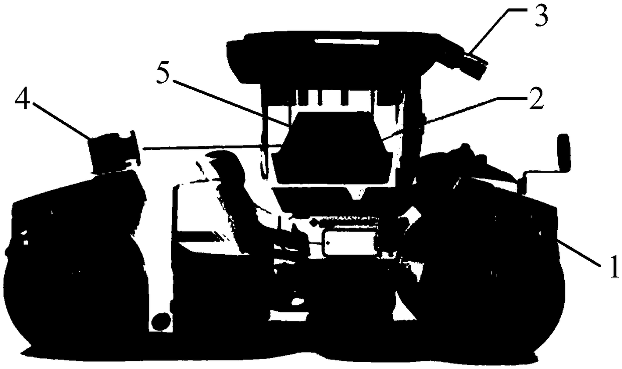
[0047] Such as figure 1 As shown, the industrial computer 2 is set u...


PUM


Abstract

The invention discloses a full-automatic road roller location method based on multi-source data fusion, comprising the following steps: setting a boundary marker at the boundary of a construction region, acquiring an image containing the boundary marker by a multichannel synchronous camera, acquiring point cloud data of the construction region by utilizing a laser radar, matching the image with laser point cloud data, identifying a construction region marker, and calculating a construction fence region; and calculating position and attitude information of a road roller in the construction region by utilizing fusion of the laser point cloud data and IMU output information, thus location of an unmanned road roller in the construction region is realized. By virtue of a machine vision locationmethod, vision data is fused with IMU data, a special construction environment of the road roller can be adapted, the problem of signal void due to pure dependence on GPS positioning is effectively avoided, and both location accuracy and speed can meet location and path planning requirements of the unmanned road roller in the construction environment, so that the method disclosed by the inventioncan be effectively applied to a construction site of the road roller, and the problem that the location accuracy of the road roller is poor is effectively solved.

Description

technical field [0001] The invention relates to a fully automatic road roller positioning method based on multi-source data fusion. Background technique [0002] Construction machinery is often used in disaster sites such as earthquakes, floods, and tsunamis, as well as harsh working conditions of high temperature, high cold, high altitude, and high radiation. Not only is the construction efficiency low, but the operators often have to risk their lives. Using unmanned technology to optimize existing construction machinery can improve construction quality, reduce personnel costs, reduce safety hazards, and provide an important basis for realizing industrial renewal. Especially for the road roller in construction machinery, which belongs to the category of road equipment, and is widely used in the filling and compaction operations of large-scale engineering projects such as roads, railways, airport runways, dams, and stadiums. It can roll sandy, semi-viscous and Cohesive soil...

Claims


Application Information

Patent Timeline
Patent Type & Authority Applications(China)
IPC IPC(8): G01C21/00G01C21/16G01C11/00G01S17/02
CPCG01C11/00G01C21/005G01C21/165G01S17/86
Inventor 李煊鹏李宇杰谌中平王东张为公许剑邹承利
Owner 中科微易(苏州)智能科技有限公司
Why Eureka
Try Eureka