Unmanned aerial vehicle airborne radar mine mining land change monitoring system and method

An airborne radar and unmanned aerial vehicle technology, applied in radio wave measurement systems, satellite radio beacon positioning systems, measurement devices, etc. No waiting questions

Pending Publication Date: 2019-01-04
XIAN CENT OF GEOLOGICAL SURVEY CGS +1
View PDF2 Cites 31 Cited by
  • Summary
  • Abstract
  • Description
  • Claims
  • Application Information

AI Technical Summary

Problems solved by technology

[0004] (2) Satellite radar INSAR technology, although it can measure surface changes in mine development, the measurement results can form "planar" data, which can only reflect area changes, and it is difficult to form a three-dimensional map with both area changes and elevation changes ; Its disadvantage is that it cannot obtain data independently at any time, and the monitoring accuracy of drastic changes in elevation, such as mining subsidence, is not accurate
[0007] In the past, mine land change monitoring mainly used traditional "contact" single-point measurement methods such as leveling technology and GPS measurement technology. Due to the limitation of terrain and ground conditions, and the acquired data are scattered, it is difficult to reflect the results of three-dimensional monitoring
INSAR technology is mainly used for

Method used


Image

  • Unmanned aerial vehicle airborne radar mine mining land change monitoring system and method
  • Unmanned aerial vehicle airborne radar mine mining land change monitoring system and method
  • Unmanned aerial vehicle airborne radar mine mining land change monitoring system and method

Examples


Embodiment Construction

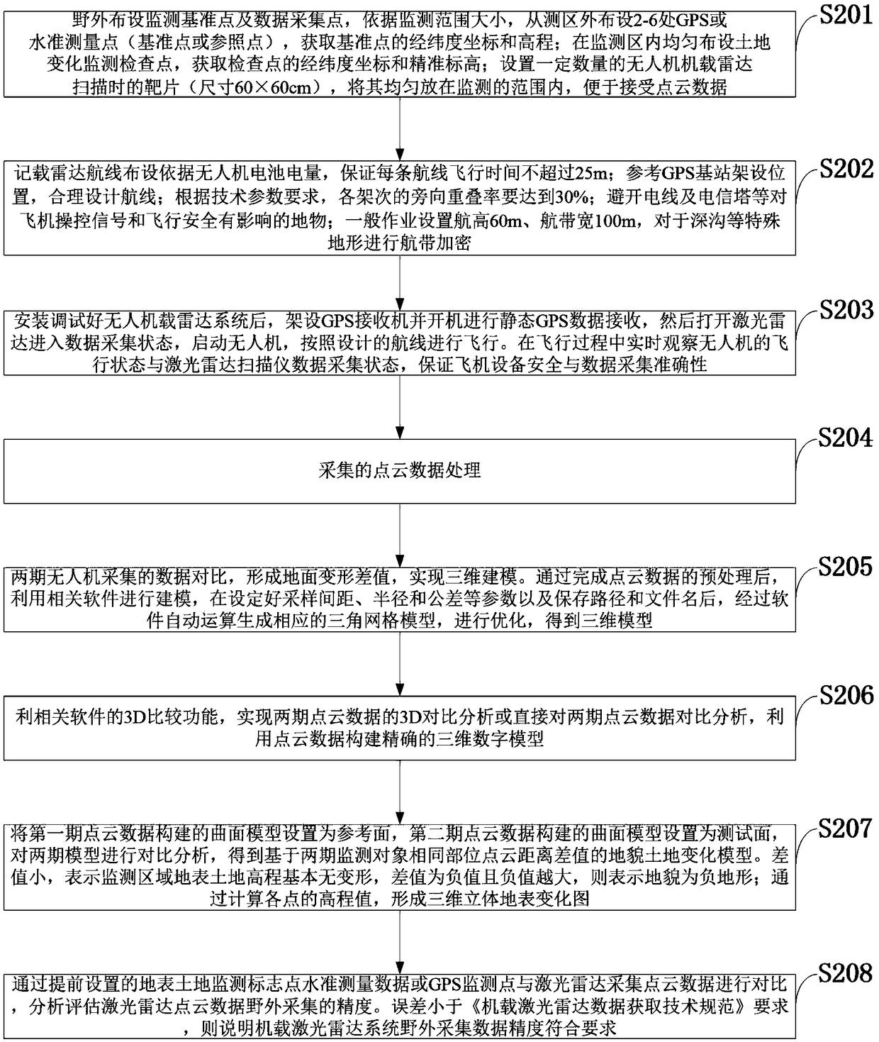
[0053] In order to make the object, technical solution and advantages of the present invention more clear, the present invention will be further described in detail below in conjunction with the examples. It should be understood that the specific embodiments described here are only used to explain the present invention, not to limit the present invention.

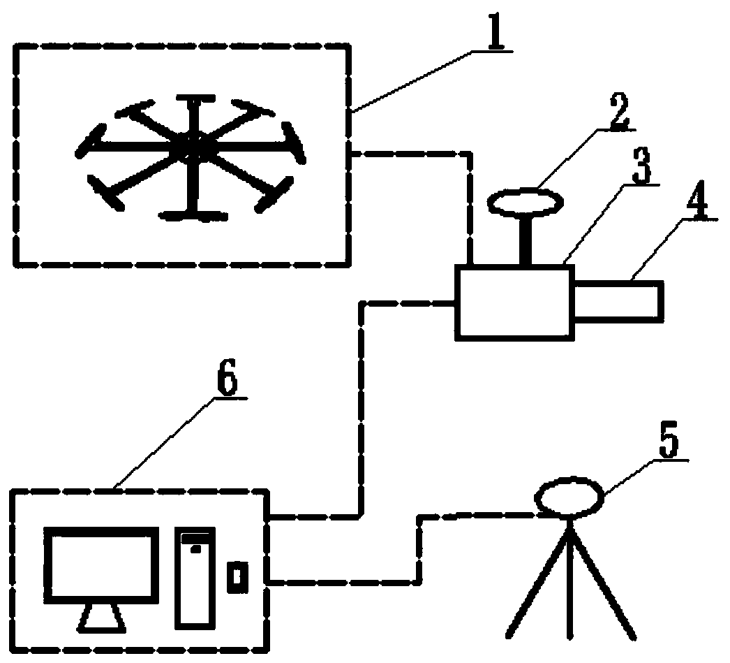
[0054] UAV airborne lidar monitoring is a kind of monitoring of surface elevation changes using laser technology. At present, the technology is still in the exploratory stage, especially in the changes of surface landforms such as open-pit mining pits and waste rock dumps, underground mining goaf subsidence, etc. Surface subsidence changes, landslides, landslides, debris flow deposits, etc., there is no corresponding UAV airborne radar monitoring technology, application cases and technical processes; there is no professional and mature point cloud data processing technology method for UAV airborne radar collection and proce...


PUM


Abstract

The invention belongs to the technical field of mine geological monitoring, and discloses a non-fixed wing unmanned aerial vehicle airborne radar mine mining land change monitoring system and method.The system comprises a non-fixed wing unmanned aerial vehicle for loading a lidar, a lidar GPS receiver, an inertial navigation system, a laser transceiver, a static GPS receiver and a control and a post-processing system, and comprises inertial navigation control software, LIDAR data acquisition software, trajectory calculation software, point cloud data calculation post-processing software and point cloud post-processing software. Through acquisition of two or more periods of point cloud data of the non-fixed wing unmanned aerial vehicle airborne radar, changes of mine surface geomorphological height differences in different time periods are formed, a new mine mining land area and elevation change monitoring technology is provided, surface elevation changes such as a mine open mining pit, a slag disposing area and mining subsidence are grasped, and scientific basis is provided for mine geological environment control, land reclamation and development, use and planning.

Description

technical field [0001] The invention belongs to the technical field of mine geological monitoring, and in particular relates to a monitoring system and method for mining damaged land changes by unmanned aerial vehicle airborne radar. Background technique [0002] At present, the methods and instruments for monitoring land elevation changes in mines include geoids, high-precision GPS, INSAR, and three-dimensional laser scanners. [0003] (1) Traditional artificial geodetic level measurement, or high-precision GPS technology, conduct point-to-point measurement of elevation points on the ground to form "point"-shaped elevation change data. The measurements form a surface-like graph rather than a three-dimensional map of surface elevation changes; [0004] (2) Satellite radar INSAR technology, although it can measure surface changes in mine development, the measurement results can form "planar" data, which can only reflect area changes, and it is difficult to form a three-dimen...

Claims


Application Information

Patent Timeline
IPC IPC(8): G01S17/88G01S7/481G01S19/14
CPCG01S7/481G01S17/88G01S19/14
Inventor 徐友宁张永庭魏采用梁伟张江华杨敏
Owner XIAN CENT OF GEOLOGICAL SURVEY CGS
Why Eureka
Try Eureka