Accurate planting system and method
A planting system and precise technology, applied in the field of plant planting systems, can solve the problems of low precision and low planting efficiency in large areas, and achieve the effect of simple equipment maintenance and increased vegetation coverage
- Summary
- Abstract
- Description
- Claims
- Application Information
AI Technical Summary
Problems solved by technology
Method used
Image
Examples
Embodiment 1
[0046] A precision planting system, including an autonomous navigation drone, a ground planting system and a ground computer for processing information;
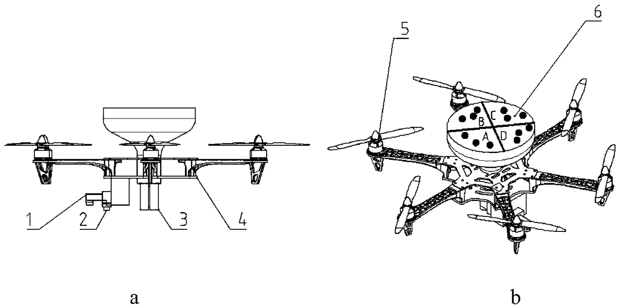
[0047] Such as figure 1 : the unmanned aerial vehicle comprises unmanned aerial vehicle stage 4, is fixed on the rotor 5 around the object stage, motor and is arranged on the landing gear under the object stage; Also is loaded with unmanned aerial vehicle on the described autonomous navigation unmanned aerial vehicle Remote sensing detection system and aerial seeding system;
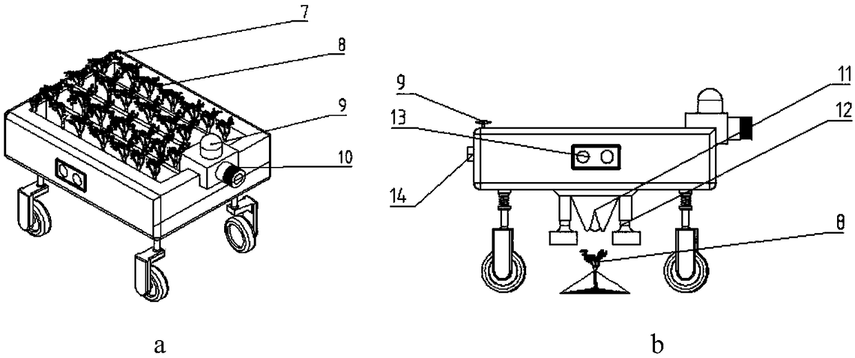
[0048] The ground planting system includes an unmanned vehicle, which is also equipped with an autonomous navigation module and a planting module;
[0049] The ground computer is used to analyze the vegetation information obtained by the drone, and generate a replanting trajectory map to control the drone's autonomous route flight and the unmanned vehicle's autonomous walking.
[0050] Such as figure 1 : The UAV remote sensing detection system inclu...
Embodiment 2
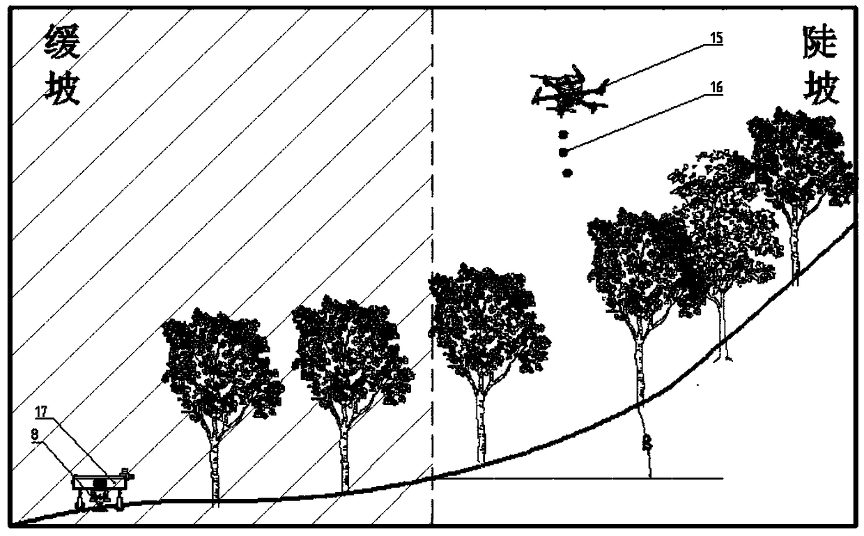
[0055] Option 1: UAV replanting operation, the UAV flies autonomously above the forest area, uses the UAV remote sensing detection system for tree density detection and terrain analysis, uses the spectrum camera on the UAV to detect tree density, and the camera Take an image of the forest area, transmit the image information back to the ground computer, and the computer will analyze it. According to the comparison and analysis of the stand density detected by the spectral camera and the normal density, the required replanting position will be obtained, and then the UAV replanting track map will be generated. Analysis If the pictures taken by the camera are analyzed according to the pictures taken by the camera and the terrain is steep or interlaced with flat and steep terrain, the computer will issue instructions to make the drone fly to the required replanting position according to the route to sow and replant;
[0056] Option 2: Replanting with unmanned vehicles, the drone fl...
Embodiment 3
[0058] Such as Figure 3-5 : a precision planting method,
[0059] Step 1: The UAV flies over the designated forest area for inspection, takes pictures with the camera and spectral camera, and transmits the obtained forest area image, forest stand and tree density results to the ground computer.
[0060] Step 2: The ground computer analyzes and judges according to the obtained transmitted information, generates a replanting trajectory map, and issues instructions.
[0061] Step 3: According to the information obtained in step 2, if it is a steep landform or when flat and steep landforms intersect, the UAV will replant according to the replanting track map after receiving instructions; if it is a flat landform, the unmanned vehicle will After the instruction is received, replant according to the replant trajectory diagram.
[0062] The drone 15 first detects above or to the side of the plants, and the remote sensing device collects vegetation images to obtain existing vegetat...
PUM
 Abstract
Description
Claims
Application Information
 - R&D
- Intellectual Property
- Life Sciences
- Materials
- Tech Scout
- Unparalleled Data Quality
- Higher Quality Content
- 60% Fewer Hallucinations
Browse by: Latest US Patents, China's latest patents, Technical Efficacy Thesaurus, Application Domain, Technology Topic, Popular Technical Reports.
© 2025 PatSnap. All rights reserved.Legal|Privacy policy|Modern Slavery Act Transparency Statement|Sitemap|About US| Contact US: help@patsnap.com


