A general database method for spatial data of regional agricultural planning

A technology for planning space and database, applied in the field of regional planning space database construction system, it can solve the problems of large amount of data, many uncertain factors, repeated data construction, etc., and achieve the effect of improving efficiency, reducing duplication and improving accuracy.

Inactive Publication Date: 2019-01-18
广东省农业科学院农业经济与农村发展研究所
View PDF3 Cites 0 Cited by
  • Summary
  • Abstract
  • Description
  • Claims
  • Application Information

AI Technical Summary

Problems solved by technology

[0003] Because regional agricultural planning is a complex systematic project, with the characteristics of large amount of data, many uncertain factors, wide range of fields involved, and rapid changes in the status quo, coupled with the professional limitations of planners and backward technical methods, the current agricultural planning has long-term existence space. Problems such as scattered and messy data, repeated data construction, and less spatial quantitative analysis

Method used


Image

  • A general database method for spatial data of regional agricultural planning
  • A general database method for spatial data of regional agricultural planning

Examples


Embodiment

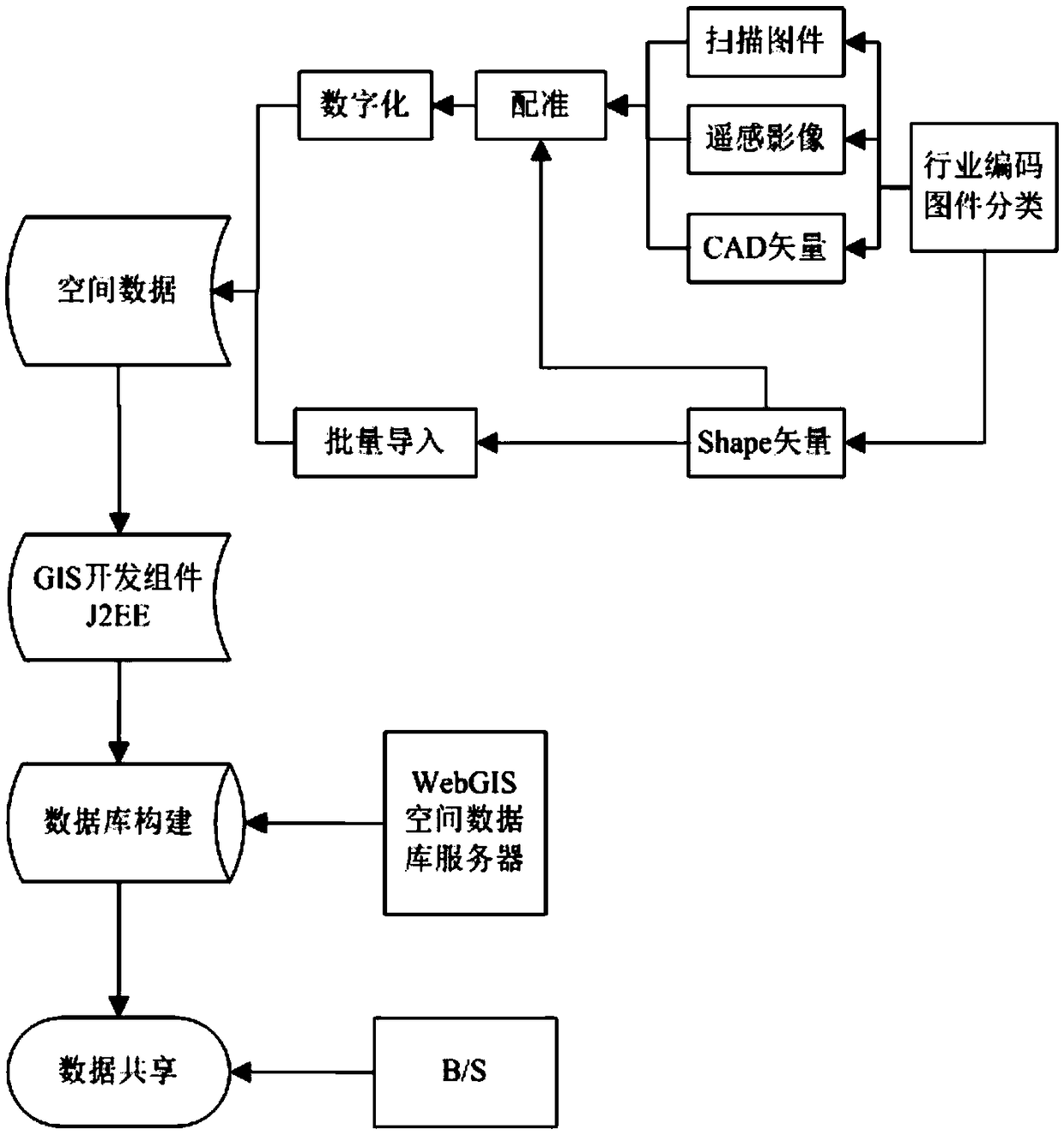
[0028] Spatial Data Classification and Industry Classification

[0029] (1) Carry out industry classification, classify and establish relevant spatial data attribute fields according to the relevant industry categories involved in regional agricultural planning, including administrative divisions, land use status, land use planning, transportation, water system, climate, environmental protection, terrain, soil, and upper-level planning , related thematic planning data, project scope spatial layer data and project information data, etc., the fields are constructed according to the specifications of each industry. The general fields include category, area, code, name, etc., and reserve custom fields to construct points, Line and area layer templates;

[0030] (2) Data classification: Spatial data is divided into scanned maps, remote sensing images, Shape vectors and CAD vectors.

[0031] Spatial database construction

[0032] (1) For scanned maps and remote sensing images, imp...


PUM


Abstract

The spatial data involved in the regional agricultural planning are classified and coded according to the industry standards such as administrative division and land use, and the general template is constructed. Classifying according to scanned map, remote sensing image, CAD, shape and so on; using unified spatial projection and coordinates for registration, digitization and attribute data input and data import, and then building a general spatial database of regional agricultural planning. The invention aims at the scattered and disorderly spatial data existing in the regional agricultural planning, The spatial data analysis of related industries is inadequate, and C/S is used to build a unified spatial database to achieve data sharing through B/S, reduce the repeated requests for spatialdata of regional agricultural planning, spatial projection is not unified, and provide accurate spatial data for the spatial analysis and layout of regional agricultural planning, project site selection, and so on.

Description

technical field [0001] The invention belongs to a regional planning spatial database construction system, in particular to a general database building method for regional agricultural planning spatial data. Background technique [0002] Regional agricultural planning is based on the needs of national economic development in a certain period of time, and on the basis of fully considering the existing agricultural development status, natural resources, social and economic conditions, ecological environment, etc. The overall deployment of efficient resource utilization and rational space layout is a systematic project of goals and constraints, organization and implementation. More than 3,000 cities and counties across the country have carried out agricultural planning work in different regions. [0003] Because regional agricultural planning is a complex systematic project, with the characteristics of large amount of data, many uncertain factors, wide range of fields involved,...

Claims


Application Information

Patent Timeline
Patent Type & Authority Applications(China)
IPC IPC(8): G06F16/29G06F16/21
Inventor 刘序周灿芳余华荣雷百战
Owner 广东省农业科学院农业经济与农村发展研究所
Why Eureka
Try Eureka