Arid region dust-haze pollution early warning method based on remote sensing technology

A remote sensing technology, a technology for arid areas, applied in the early warning field of haze pollution in arid areas based on remote sensing technology, can solve the problems of unsuitable aerosol inversion, low resolution of satellite remote sensing platform, and low inversion accuracy of arid areas, and achieve The effect of scientific and reasonable classification of haze pollution early warning levels, improved accuracy and timeliness, and high spatial resolution of retrieval

Active Publication Date: 2019-03-01
甘肃省环境科学设计研究院
View PDF2 Cites 2 Cited by
  • Summary
  • Abstract
  • Description
  • Claims
  • Application Information

AI Technical Summary

Problems solved by technology

However, the current research on aerosol remote sensing inversion mostly relies on medium and low-resolution remote sensing images such as MODIS, and the aerosol optical depth obtained from the inversion has low accuracy; The representativeness of the inversion results is not strong; due to the lack of ground monitoring data corresponding to multi-temporal weather with different characteristics, existing related research cannot accurately construct the correlation between the inversion of aerosol optical depth and air pollution
[0005] For the research on early warning of haze pollution based on remote sensing technology, so far, domestic and foreign scholars have not yet formulated a set of scientific and accurate aerosol optical depth retrieval algorithms suitable for cities in arid regions. The resolution of the remote sensing platform

Method used


Image

  • Arid region dust-haze pollution early warning method based on remote sensing technology
  • Arid region dust-haze pollution early warning method based on remote sensing technology
  • Arid region dust-haze pollution early warning method based on remote sensing technology

Examples


Embodiment

[0042] Examples The present invention is implemented in the arid area city-Lanzhou City.

[0043] An early warning method for haze pollution in arid areas based on remote sensing technology, including the following steps:

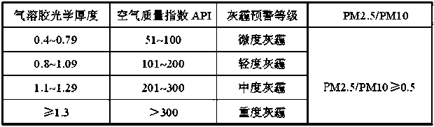
[0044] ⑴Set up a server at any place in Lanzhou City with network connection. The server is equipped with a data comprehensive analysis system including a haze pollution ground monitoring module, an environmental small satellite data processing module, a weather monitoring data module, and a gray system including a standard module for early warning levels. Haze pollution warning system.

[0045] ⑵Using the remote sensing image data covering the four different seasons of Lanzhou city received by the existing environmental small satellite national ground receiving station receiving system, select the cloudless or less clouded image, write the radiance calculation program through IDL, and integrate the program into In the environmental small satellite data processin...


PUM


Abstract

The invention relates to an arid region dust-haze pollution early warning method based on a remote sensing technology. The method comprises the following steps: (1) arranging a server provided with adata comprehensive analysis system and a dust-haze pollution early warning system on any place with network connections in cities of an arid region; (2) converting a pixel DN value into a radiation brightness value by utilizing remote sensing image data; (3) converting the radiation brightness value into a satellite appearance reflectance; (4) programming, removing the image, and geometrically correcting the image; (5) acquiring observation geometric information and observation geometric angle file of a satellite; (6) establishing a lookup table comprising an observation geometry, surface reflectance, satellite appearance reflectance and aerosol optical thickness; (7) searching the aerosol optical thickness corresponding to a blue light waveband; (8) establishing a relation between the aerosol optical thickness and air pollution; (9) establishing an early warning grade classification standard, and identifying a dust-haze pollution grade according to an air quality index and an air particulate matter concentration value; and (10) starting the dust-haze pollution early warning. The arid region dust-haze pollution early warning method of the invention is high in accuracy and timeliness.

Description

Technical field [0001] The invention relates to the technical field of early warning of haze pollution, in particular to a method for early warning of haze pollution in arid areas based on remote sensing technology. Background technique [0002] Remote sensing technology is a detection technology that emerged in the 1960s. Based on the theory of electromagnetic waves, various sensing instruments are used to collect, process, and finally image the electromagnetic wave information radiated and reflected by remote targets. A comprehensive technology for detecting and identifying a kind of scenery. Remote sensing technology has been widely used in military, national defense, agriculture, forestry, land, ocean, surveying and mapping, meteorology, ecological environment, water conservancy, aerospace, geology, minerals, archaeology, tourism and other fields, affecting all aspects of human life. Provides new methods and new means to understand the world from a multi-dimensional and macr...

Claims


Application Information

Patent Timeline
IPC IPC(8): G01N15/06G01N33/00G08B21/18
CPCG01N15/06G01N33/0065G08B21/182Y02A50/20
Inventor 赵晓冏苏军德
Owner 甘肃省环境科学设计研究院
Why Eureka
Try Eureka