Rice overground portion biomass estimation method based on multispectral images of unmanned aerial vehicle

A multi-spectral imaging and biomass technology, applied in unmanned aerial vehicles, color/spectral characteristic measurement, rice cultivation, etc., can solve the problems of rarely estimating rice biomass, poor monitoring effect, etc., and meet the input data requirements The effect of low and high estimation accuracy

Active Publication Date: 2019-03-12
NANJING AGRICULTURAL UNIVERSITY
View PDF13 Cites 31 Cited by
  • Summary
  • Abstract
  • Description
  • Claims
  • Application Information

AI Technical Summary

Problems solved by technology

[0005] Predecessors mainly used the texture features of satellite images to estimate forest biomass, and few studies used ultra-high resolution UAV images to estimate rice biomass
In addition, the traditional spectral index is not effective in monitoring high biomass, especially in the growth period of rice after heading.

Method used


Image

  • Rice overground portion biomass estimation method based on multispectral images of unmanned aerial vehicle
  • Rice overground portion biomass estimation method based on multispectral images of unmanned aerial vehicle
  • Rice overground portion biomass estimation method based on multispectral images of unmanned aerial vehicle

Examples


Embodiment 1

[0034] The present invention is based on the paddy field experiments of different growth periods, different nitrogen application levels, and different planting densities, and the specific expressions are as shown in Table 1 and Table 2:

[0035] Table 1 Basic information of rice experimental fields

[0036]

[0037] Table 2 Data collection of rice canopy images and agronomic parameters

[0038]

[0039]

[0040] The rice canopy multi-spectral image data was obtained from the rice experimental fields Exp.1 and Exp.2. The data acquisition is highly systematic, covers two main rice varieties, includes the main growth period, and has a large number of samples and many processing factors, which can be effectively Verify the accuracy and adaptability of the identification method of the present invention under different environmental conditions and treatments.

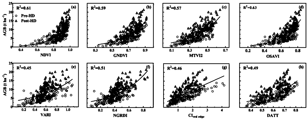
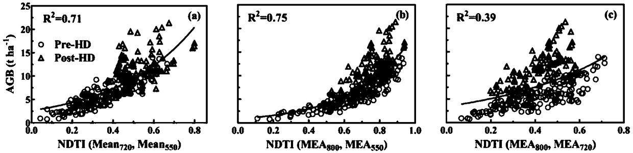
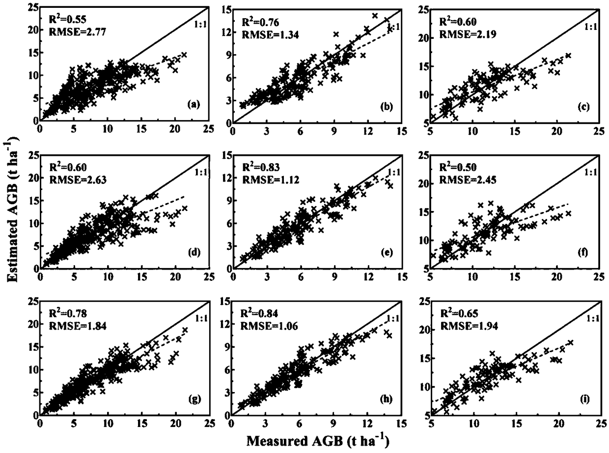
[0041] The specific steps of a method for estimating aboveground biomass of rice based on UAV multispectral images ...


PUM


Abstract

The invention a rice overground portion biomass estimation method based on multispectral images of an unmanned aerial vehicle. The rice overground portion biomass estimation method based on the multispectral images of the unmanned aerial vehicle comprises the following steps: standardly acquiring rice canopy unmanned aerial vehicle multispectral image data and ground actually measured biomass data; after the data are acquired, preprocessing images, extracting reflectivity and texture feature parameters, calculating vegetation indexes, and constructing new texture indexes; and integrating the vegetation indexes and the texture indexes to estimate rice biomass by using a step-by-step multivariate regression analysis method, and establishing a multivariate linear model for estimating the biomass on that basis. The precision of a new estimation model is verified by a cross validation method. By the method, the estimation precision is high, the requirements for input data are low, the riceoverground portion biomass estimation method based on the multispectral images of the unmanned aerial vehicle is suitable for rice in the whole growth period, meanwhile, the method for establishing the biomass of rice by integrating unmanned aerial vehicle spectra and texture information is proposed for the first time at present, and thus, the rice overground portion biomass estimation method based on the multispectral images of the unmanned aerial vehicle can be widely used for monitoring crop growth in a remote sensing manner by the unmanned aerial vehicle.

Description

technical field [0001] The invention belongs to the field of crop growth monitoring, in particular to a method for estimating aboveground biomass of rice based on multispectral images of drones. Background technique [0002] Rice is one of the main food crops in the world. More than half of the world's population depends on rice as a staple food. Therefore, rice production plays an important role in global food security and sustainable development. Precise crop management is a prerequisite for ensuring high rice yields, and aboveground biomass is an important indicator for monitoring crop growth and has a major impact on yield formation. At the same time, biomass and nitrogen content jointly determine the nitrogen dilution curve, from which the critical nitrogen concentration can be obtained, and then the nitrogen nutrition index can be calculated for nitrogen management. Therefore, it can be seen that the accurate and non-destructive monitoring of crop population biomass p...

Claims


Application Information

Patent Timeline
Patent Type & Authority Applications(China)
IPC IPC(8): G01N21/25G01N21/84G06V10/143
CPCG01N21/25G01N21/84G01N2021/8466B64U2101/30G01N21/31A01G22/22G06T7/45G06T7/0002G06T2207/10036G06T2207/30188G06V20/194G06V20/188G06V10/143G06V20/17G06T5/002G06T5/006G06T7/62B64C39/02G06T7/40
Inventor 朱艳郑恒彪程涛姚霞田永超曹卫星
Owner NANJING AGRICULTURAL UNIVERSITY
Why Eureka
Try Eureka