
Topographic surveying and mapping method, device, flight platform, computer equipment and storage medium

A technology of terrain surveying and mapping and flying platform, which is applied in the directions of surveying devices, aircraft, camera devices, etc., can solve the problems of low surveying and mapping efficiency, and achieve the effect of rapid terrain surveying, reducing manpower and improving efficiency.

Active Publication Date: 2020-02-18
GUANGZHOU POWER SUPPLY BUREAU GUANGDONG POWER GRID CO LTD
View PDF5 Cites 0 Cited by
  • Summary
  • Abstract
  • Description
  • Claims
  • Application Information

AI Technical Summary

Problems solved by technology

[0003] Based on this, it is necessary to address the above-mentioned technical problems and provide a terrain surveying and mapping method, device, flight platform, computer equipment and storage medium that can solve the problem of low surveying and mapping efficiency.

Method used


Image

  • Topographic surveying and mapping method, device, flight platform, computer equipment and storage medium
  • Topographic surveying and mapping method, device, flight platform, computer equipment and storage medium
  • Topographic surveying and mapping method, device, flight platform, computer equipment and storage medium

Examples


Embodiment Construction

[0040] In order to make the purpose, technical solution and advantages of the present application clearer, the present application will be further described in detail below in conjunction with the accompanying drawings and embodiments. It should be understood that the specific embodiments described here are only used to explain the present application, and are not intended to limit the present application.

[0041] The terrain surveying and mapping method provided by this application can be applied to such as figure 1 shown in the application environment. Wherein, the flying platform 102 communicates wirelessly with the server 104 . Among them, the flight platform 102 can be, but not limited to, various special-purpose surveying and mapping drones, civilian drones, and shooting drones, etc., and the server 104 can be realized by an independent server or a server cluster composed of multiple servers.

[0042] The flight platform 102 communicates wirelessly with the server 104...


PUM


Abstract

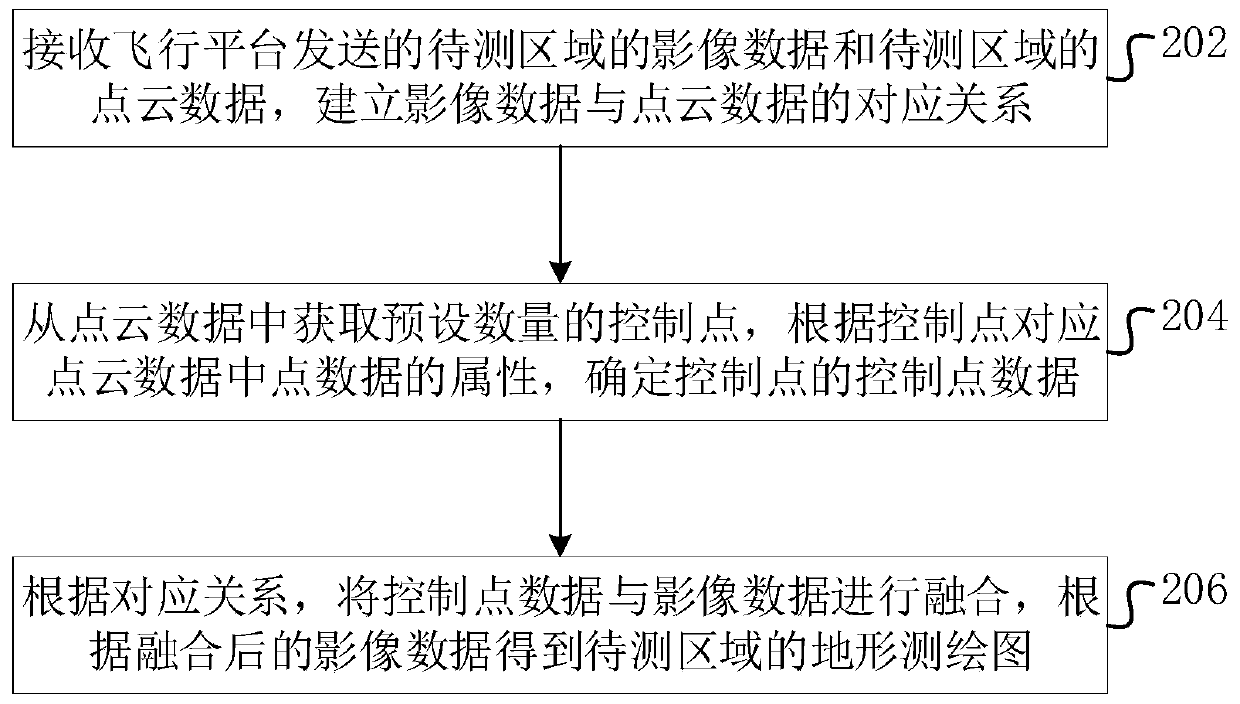
The present application relates to a topographic surveying and mapping method, device, flight platform, computer equipment and storage medium. The method includes: receiving the image data of the area to be measured and the point cloud data of the area to be measured sent by the flight platform, establishing a corresponding relationship between the image data and the point cloud data, and obtaining a preset number of control points from the point cloud data According to the attribute of the point data in the point cloud data corresponding to the control point, the control point data of the control point is determined, and the control point data is fused with the image data according to the corresponding relationship, and the topographic map of the area to be measured is obtained according to the fused image data . The method can improve the efficiency of terrain surveying and mapping.

Description

technical field [0001] The present application relates to the technical field of terrain surveying and mapping, in particular to a terrain surveying and mapping method, device, flight platform, computer equipment and storage medium. Background technique [0002] UAV aerial photography system is a new means of surveying and mapping of national large-scale infrastructure projects, and its work efficiency has obvious advantages compared with traditional surveying and mapping. When performing aerial photography and mapping, the controller controls the UAV to shoot in the area to be measured, obtains the captured image data, and calculates the data of unknown points by analyzing the position of the control points in the image data, thereby completing the measurement of the area to be measured Surveying and mapping, however, needs to be manually arranged on the ground before aerial photography, which requires a lot of manpower and material resources for support, which affects the ...

Claims


Application Information

Patent Timeline
Patent Type & Authority Patents(China)
IPC IPC(8): G01C11/02G01C11/04G01C15/00B64D47/08B64C39/02
CPCG01C11/02G01C11/04G01C15/00B64C39/02B64D47/08B64U2101/00
Inventor 邓填棣刘艳军谢剑翔陶冠男张群郑莹吴浚铭李子森
Owner GUANGZHOU POWER SUPPLY BUREAU GUANGDONG POWER GRID CO LTD
Learn More