
Grassland vegetation degradation remote sensing monitoring method and device

A technology of remote sensing monitoring and grassland, applied in the field of remote sensing monitoring of grassland vegetation degradation, can solve the problem that the index stability is easily affected by vegetation and environmental changes, and the stability is easily affected by vegetation and environmental changes, and it is difficult to accurately evaluate the grassland vegetation degradation status and other problems, to avoid low evaluation accuracy, help popularize applications, and evaluate efficient effects

Inactive Publication Date: 2019-04-12
INST OF AGRI RESOURCES & REGIONAL PLANNING CHINESE ACADEMY OF AGRI SCI +1
View PDF1 Cites 6 Cited by
  • Summary
  • Abstract
  • Description
  • Claims
  • Application Information

AI Technical Summary

Problems solved by technology

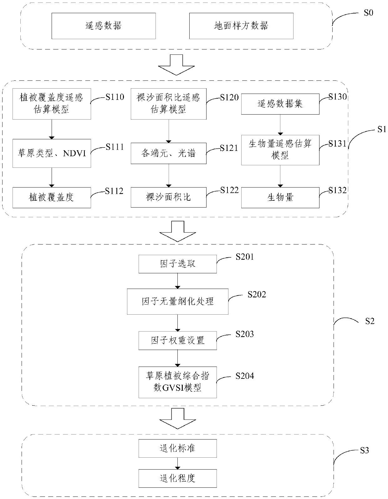
Grassland vegetation coverage and biomass are single indicators reflecting the status of grassland vegetation, which can reflect the characteristics of grassland vegetation from different aspects, but the stability of each single indicator is easily affected by vegetation and environmental changes
[0004] The use of remote sensing technology to carry out grassland degradation assessment has obvious advantages such as rapidity and large scale. However, due to the complexity of grassland types and large environmental variations, a single remote sensing model that uses remote sensing data to calculate key parameters of vegetation such as grassland vegetation coverage and biomass is not stable. are easily affected by vegetation and environmental changes, and it is difficult to accurately evaluate the degradation of grassland vegetation in large-scale and complex grassland characteristic regions

Method used


Image

  • Grassland vegetation degradation remote sensing monitoring method and device
  • Grassland vegetation degradation remote sensing monitoring method and device
  • Grassland vegetation degradation remote sensing monitoring method and device

Examples


Embodiment Construction

[0020] In order to make the purpose, technical solutions and advantages of the embodiments of the present invention clearer, the technical solutions in the embodiments of the present invention will be clearly and completely described below in conjunction with the drawings in the embodiments of the present invention. Obviously, the described embodiments It is a part of embodiments of the present invention, but not all embodiments. Based on the embodiments of the present invention, all other embodiments obtained by persons of ordinary skill in the art without creative efforts fall within the protection scope of the present invention.

[0021] Remote sensing technology provides an effective way and technical support for large-scale, rapid and accurate monitoring of the ecological status of grassland vegetation, and has become an important means of monitoring grassland vegetation status. One of the key technologies for remote sensing monitoring and evaluation of grassland degradat...


PUM


Abstract

The embodiment of the invention provides a grassland vegetation degradation remote sensing monitoring method and device, and the method comprises the steps: obtaining the vegetation coverage and baresand area ratio of a grassland based on remote sensing data, and obtaining the biomass of the grassland based on the remote sensing data and ground quadrat data; and obtaining the grassland vegetationcomprehensive index GVSI based on the vegetation coverage, the bare sand area ratio and the weight coefficient of the biomass when reflecting the grassland vegetation condition. Multi-factor indexessuch as vegetation coverage, biomass and bare sand area ratio of the grassland are comprehensively considered, and the vegetation degradation condition of the grassland is more comprehensively reflected; the problems of low precision and poor stability of grassland degradation remote sensing monitoring evaluation carried out by a single factor are avoided; the calculated degradation level is smallin comparison error with the field investigation degradation level, multiple factors are integrated, evaluation is more efficient and more reliable, and application and popularization are facilitated.

Description

technical field [0001] Embodiments of the present invention relate to the technical field of ecological monitoring, and more specifically, to a remote sensing monitoring method and device for grassland vegetation degradation. Background technique [0002] 90% of the country's available natural grasslands have been degraded to varying degrees, and half of them have been degraded to a moderate or higher level. Grassland ecological problems are serious. For example, grasslands in Xinjiang are widely distributed. They are not only the main support of grassland animal husbandry and a rich biological gene pool, but also play an important ecological role in maintaining ecological security, protecting oases and water conservation. Grassland vegetation is a general term for various plants or plant communities that cover the grassland area and are suitable for environmental conditions. The ecological status is the similarity between the terrain vegetation and the top community of the ...

Claims


Application Information

Patent Timeline
Patent Type & Authority Applications(China)
IPC IPC(8): G06Q10/06G06Q50/26
CPCG06Q10/06393G06Q50/26
Inventor 金云翔阿斯娅·曼力克杨秀春徐斌张文博李学森郑逢令陈实郭剑申格
Owner INST OF AGRI RESOURCES & REGIONAL PLANNING CHINESE ACADEMY OF AGRI SCI
Learn More