A method for reducing that scale of surface temperature space

A surface temperature and downscaling technology, applied in the field of remote sensing measurement, can solve the problem of incomplete overview of the complex relationship between different scale factors and surface temperature

Inactive Publication Date: 2019-04-16
GUANGZHOU INST OF GEOGRAPHY GUANGDONG ACAD OF SCI
View PDF5 Cites 33 Cited by
  • Summary
  • Abstract
  • Description
  • Claims
  • Application Information

AI Technical Summary

Problems solved by technology

However, these simple single-factor and multi-factor regression relationships cannot fu...

Method used


Image

  • A method for reducing that scale of surface temperature space
  • A method for reducing that scale of surface temperature space
  • A method for reducing that scale of surface temperature space

Examples


Embodiment Construction

[0040] Below, in conjunction with accompanying drawing and specific embodiment, the present invention is described further:

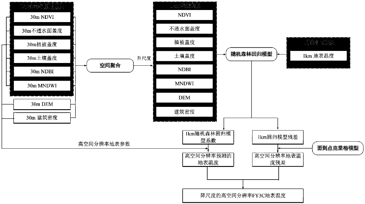
[0041] Aiming at the problem of low spatial resolution of FY3C-VIRR surface temperature products, this example uses random forest and surface-to-point Kriging methods to obtain surface parameters such as NDVI, NDBI, MNDWI, impermeable surface coverage, DEM, and building density. As an indicator factor, a spatial downscaling model of the FY3C-VIRR surface temperature product is constructed, and the 1km surface temperature product is downscaled to 30m resolution, that is, in this embodiment, the low spatial resolution refers to the 1km resolution , high spatial resolution refers to the 30m resolution rate. refer to figure 1 As shown, this method specifically includes:

[0042] (1) Image data acquisition and preprocessing

[0043] First, download the Landsat 8OLI image data from the Earth Resources Observation and Science Center of the US Federal Geolog...


PUM


Abstract

The invention discloses a method for reducing that scale of surface temperature space. At first, that method quantitatively analyzes the surface temperature and the surface parameters including the impervious surface coverage, vegetation coverage, soil coverage, NDVI, NDBI, MNDWI, DEM, and the correlation between building density and its spatial distribution difference, Then the regression model of low spatial resolution land surface temperature products and related land surface parameters is established by using machine learning stochastic forest algorithm, land surface temperature with highspatial resolution can be predicted by combining the land surface parameters with high spatial resolution, Then the area-to-point Kriging interpolation method of geostatistics is used to reduce the residuals of the random forest regression model to improve the spatial resolution of the residuals, Finally, the high spatial resolution stochastic forest regression model and the surface-to-point Kriging interpolation residuals are added to generate high resolution and high precision surface temperature products to make up for the lack of spatial resolution of the existing surface temperature products.

Description

technical field [0001] The invention relates to the technical field of remote sensing measurement, in particular to a spatial downscaling method for surface temperature based on machine learning and geostatistical theory. Background technique [0002] LST is a key parameter of land surface system processes at regional and global scales, integrating the combined results of surface-atmosphere interaction and energy exchange between atmosphere and land. Surface temperature can provide information on temporal and spatial changes of surface energy balance, and has been widely used in research fields such as meteorology, geology, hydrology, ecology, numerical forecasting, and regional climate models, and has become the main parameter for urban heat island monitoring and heat island effect research. . Accurate surface temperature not only helps to evaluate surface energy and hydrological balance, thermal inertia and soil moisture, but also helps to obtain global surface temperatur...

Claims


Application Information

Patent Timeline
IPC IPC(8): G06F17/50
CPCG06F30/20
Inventor 许剑辉张菲菲赵怡钟凯文胡泓达戴健钊
Owner GUANGZHOU INST OF GEOGRAPHY GUANGDONG ACAD OF SCI
Why Eureka
Try Eureka